
-
 8968 Hits
-
 87.31% Score
-
 24 Votes
|
|
Mountain/Rock |
|---|---|
|
|
46.27467°N / 12.99691°E |
|
|
Hiking, Skiing |
|
|
Spring, Summer, Fall, Winter |
|
|
4849 ft / 1478 m |
|
|
Overview


The name: Cuar is a Friulan word, which means Corno (=horn).
In the easternmost part Carnic Pre-Alps are low and from the mountaineering point of view less attractive. Not so from the hiking point of view. Very panoramic peaks, still live alpine pastures, attractive mountain roads for biking, fauna and flora on the border of mediterranean and alpine world, all that is attracting visitors. And yet, one can not say that the area is overcrowded, despite the nearby big cities like Udine.
Because the southern ridges of Carnic Pre-Alps represent the first high barriers to south-west winds, bringing moisture from the Adriatic sea, the area is characterised by high amounts of precipitation (especially in spring and autumn), which all has a special effect on a dense vegetation.
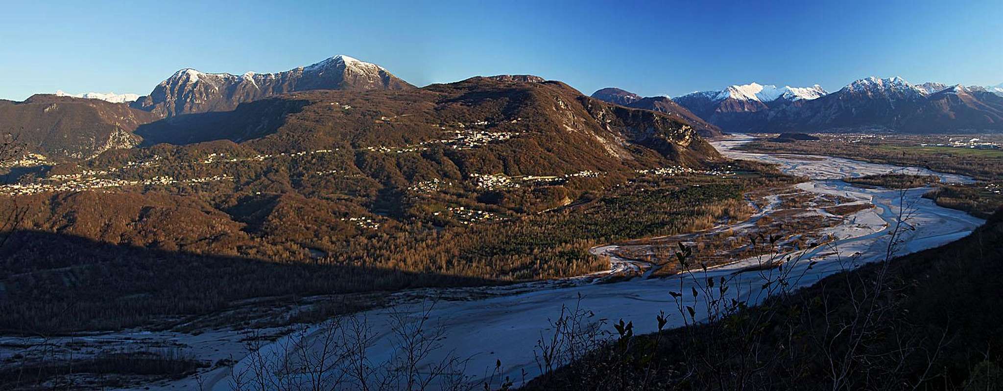
Monte Cuar massif from the south, from Monte di Ragogna
Geography
Where Tagliamento river comes out of the Alps, spilling its waters over the Po river plane, there is the border between Julian Alps on the east and Carnic Alps on the west. Some time Tagliamento flows just at foothills of the latter, and that's the area, where some 1250 meters high the slopes of Monte Cuar are rising. Above the river banks there are on sunny and fertile slopes many villages, like Avasinis, Peonis and Forgaria. From Forgaria a good road ascends towards the north, reaching first the plateau of Monte Prat and then continuing around the eastern side of Monte Cuar - first on the saddle Cuel de Forchia and then further down towards Avasinis. On Cuel de Forchia, 884 m, the massif of Monte Covria, 1160m, is attached on Monte Cuar. The western border of Cuar massif is the valley of Arzino river (Val d'Arzino). There goes the road up to Sella Chianzutan (pass) and down to Tolmezzo, the centre of Carnia mountains. And finally, north of Monte Cuar some more higher mountains are rising, representing the easternmost part ob Carnic Pre-Alps backbone.
Monte Cuar itself sends from the summit two distinct ridges: the long NW ridge runs towards the neighbouring summit of Cuel dai Poz, 1377 m, and the shorter eastern ridge (and slope) runs towards Cuel di Forchia (saddle), 884 m. The southern and south-western slopes of Monte Cuar are much steeper than the northern slopes, which are soon overgrown with nice woods.
Mountain Pastures
All around Monte Cuar alpine pastures are situated. On the southern side, many are on Monte Prat plateau and in Val Tochel, NW of Monte Covria there's Malga Covria, 955 m, N of Monte Cuar there's Malga Gador, 1119 m, and finally, NW opf Monte Cuar there's the biggest and most popular one, Malga Cuar, 1219 m, where visitors can find also a mountain hut and agrotourism.
Cornino Lake

A small pearl is the blue Cornino lake, lying by the road, near (NE of) Cornino village, and SW of Peonis, just below the southern slopes of Monte Covria. It is a national reserve, a protected area, where an experiment of inhabiting griffons (a kind of white-head vultures) took place.
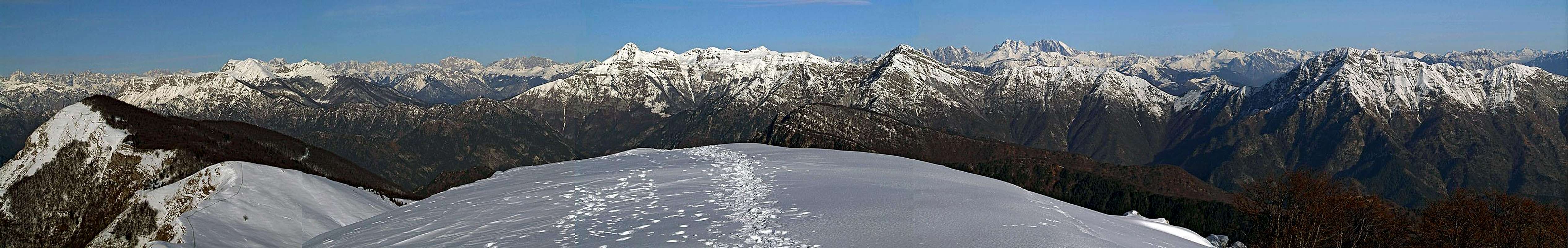
Summit Panorama
From Monte Cuar two very different landscapes can be seen: on the south the river Po plane with many towns and a dense network of roads, finally finishing in the lagunas of Adriatic sea, and on all other directions the most various mountain world of Alps. On the east one can distinguish several high peaks of Julian Alps, on the western side, in a clear day the Monte Cavallo group is beautifully distinguished. But right of it, the whole north-western and northern horizon is boiling with sharp peaks of Carnic Alps. One really has to be an expert to recognize them all.
 Monte Cavallo Monte Cavallo |
 Towards the NW Towards the NW |
 Julian Alps Julian Alps |
Getting There
Roads

On the east ridge
Most of visitors come to Monte Cuar from the south or the east. The nearest highway is Udine-Tarvisio, we must exit it in Gemona di Friuli. The already mentioned mountain road connects Forgaria on the southern slopes and Avasinis east of Monte Cuar. The ideal starting point for the ascent is Cuel di Forchia, 884 m, the saddle between Monte Cuar and Monte Covria.
Just below the saddle, on the SW side, a narrow mountain road deters up towards Monte Cuar, gains in several turns some altitude and then runs horizontally all around the eastern side of Monte Cuar. On the other side it again starts gaining altitude and first over the broad meadows of Malga Gador finally reaches the meadows of Malga Cuar, 1219m. From there you have only one good hour of hike up to the top.
Just south of Monte Cuar, there's an alpine meadow, where from the Forgaria-Avasinis road a narrow macadam road deters towards the NW. This road connects the Monte Prat plateau with Cerdevol in Val d'Arzino and is also a possible approach to the mountain.
All these mountain roads are very attractive goals for mountain (and ordinary) bikers.
Marked Paths
| See full screen |
The summit of Monte Cuar can be reached by the marked paths No. 815 (to Malga Cuar and on the highest point) and No. 815a (from Cuel di Forchia on the highest point). The latter is steeper, but in dry season still only an easy hike-up. In winter, or when the eastern ridge is covered with snow, some steep section can require some care. From Cuel di Forchia to the summit we need 1 h 15 min to 1 h 30 min, for the whole round tour (also the road to Malga Cuar) we need some 4 hours. From Cuel di Forchia also the summit of Monte Covria can be reached by a marked path. We need some 45 minutes to reach it, but it offers no views around. NW of Monte Cuar, and just above Malga Cuar, there are two more panoramic summits: Cuel dai Poz and Monte Flagel. They can be easily reached by the ridge trail and are often added to Monte Cuar to make one tour. Last to mention is the direct south route on Monte Cuar. It's the most demanding of all mentioned routes and requires some easy climbing. See more on the map! |
From the valley there are also some more marked paths, which reach the saddle of Cuel di Forchia. One goes from Peonis (first by the road, then through the woods, some 2 hours), the second one is the NE shortcut for the Avasinis road. Malga Cuar can also be reached through the forests from the northern side, but approaches are longer.
 On the E ridge On the E ridge |
 On the E ridge On the E ridge |
 The summit ridge The summit ridge |
Remark
As Fabrizio, our very active member lives at the foothills of M. Cuar, I first tried to persuade him to write the page. He generously left the task to me, but promised to participate comments and pictures.