
-
 2886 Hits
-
 78.27% Score
-
 9 Votes
|
|
Mountain/Rock |
|---|---|
|
|
46.23342°N / 12.80367°E |
|
|
Hiking |
|
|
Spring, Summer, Fall, Winter |
|
|
3615 ft / 1102 m |
|
|
Overview
Intro
Even if this summit is humble and unimportant, I'm posting this page for the sake of completeness of Carnic Alps presentation. It's the neighbouring Monte Ciaurlec, 1148 m, which should receive its own page. But I have still not ascended it. When that's done, or when this page is transferred to a member who knows the area better, the best solution would be to have a page of Monte Ciaurlec and describe there also Monte Valinis.
Monte Ciaurlec Massif
On the southern edge of Carnic Pre-Alps, just above the broad Furlania Plane, there is a low massif of Monte Ciaurlec. Its summits only hardly exceed 1000 m of altitude, which means really insignificant altitudes for the area of Alps. But the views from the summits which are not ovegrown are very nice and the unspoiled nature offers a few fine hikes. Nature there is very nice. Meadows, connected with ex shepherds paths are scattered with modest stone huts, the slopes and ridges are mostly open and panoramic, with distinct picturesque trees. More overgrown is the north oriented part of the summit plateau. Interesting is also the karstic nature of the area. The whole area of Monte Ciaurlec massif is heavily depopulated - for example, in in the last 100 years the population of Clauzetto commune dropped from some 3000 inhabitants to 440.
The western border of the area is Meduna river and the eastern border is Torrente Cosa. The northern border is Torrente Chiarzo and the southern border is Furlania plane. The town at the southern foothills is Meduno.
If we focus only on the geology of the mountaneous part of Monte Ciaurlec massif, its upper part is built of Upper Cretacious white limestones, laying on older (Upper Jurassic to Lower Cretacious) white-grey limestones.
Monte Valinis
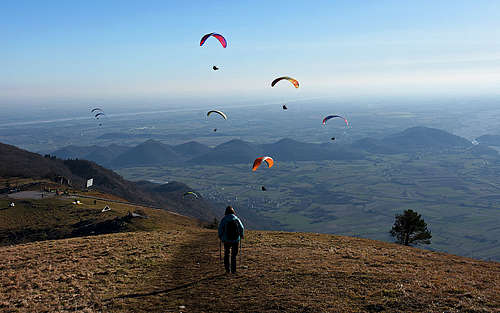
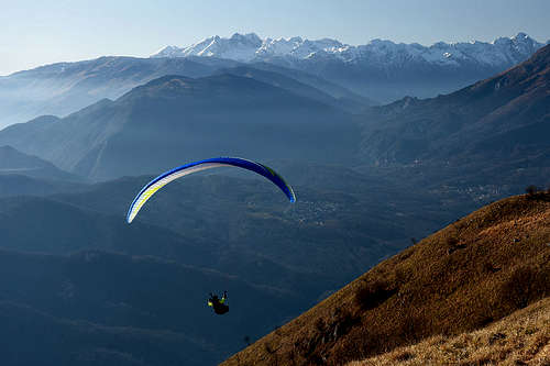
It's a grassy summit above the alpine pasture of the same name. The place is one of the most popular starting points for paragliding. It offers everything: south oriented grassy slopes for take-off, a narrow, but asphalted road just to the take-off area, 975 m, a good mountain hut on the alpine meadow. We visited the place on January 1st and due to a wonderful, warm day, there were some 50 people and that afternoon at least 30 were in the air. By the take-off area there was a tent or two, some people, accompanying gliders, were picknicking there, others came for a short hike and the place is also a valuable goal for mountain bikers.
Summit views
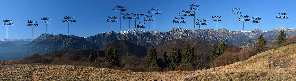


The panorama from Monte Valinis is really broad and fine. Towards the south the whole Furlania plane lies, usually in some haze. On the SW, already a bit remote, there is the group of Cimon del Cavallo and Col Nudo. On the W, the nearby summit is Monte Raut, but right of it and in the NW direction some of the finest peaks of Carnic Pre-Alps are seen. The most impressive is Monte Caserine Alte and right of it Monte Frascola. Towards the north, we see the summits above Val Meduna and behind them also some of the highest summits of Carnic Alps around Monte Coglians. Finally, in the NE direction we see behind the lower mountains of Carnic Alps also the westernmost peaks of Julian Alps.

|

|
<-- Two more characters, seen from Monte Valinis |
Grotte di Pradis
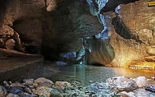

On the eastern border of the group, above the Tul lake, the creek of Cosa carved in the Upper Cretacious limestone a nice canyon, some good 1 km long with walls high up to 300 m. A part of it, near Pradis village, is arranged for tourists visit. In caves above the creek remains of Neanderthal Man were discovered, together with bones of cave bear. The narrow canyon is very picturesque, but for my taste the whole area is too much artificially changed (bridges, steps, religion symbols etc. Entrance fee is 7 EUR (2014).
Getting There
| See full screen |
For Monte Valinis, almost the exclusive trailhead is the paragliding take-off point, reachable by car. The road to Malga Valinis is probably not cleaned during winter, so check its condition in Meduno tourist office. Even if the altitude of the alpine meadow is only some 950 m, a long stretch of the road climbs up by northern slopes, where even small amounts of snow can stop you. Malga Valinis is also a suitable trailhead for Monte Ciaurlec. If you don't want to (or can't) drive up to Malga Valinis, you can find a trailhead also half way up along the access road - in Borgo Cilia, 550 m. Or, you can walk up all the way from Meduno, 300 m, which still means only 800 m of altitude gain. A better starting point than Meduno is the nearby village of Sottomonte, where the marked trail (No. 819) to Malga Valinis starts. For Monte Ciaurlec, the northern trailhead is on the road west of Pradis. The place is called I Piani, 673 m. The western trailhead is Malga Valinis. The southeastern trailhead for Monte Ciaurlec is end of the road above Travesio, on 475 m. Explore the map-guidebook on the left! It contains a lot of information. Yellow lines are mountain roads, red are marked trails, brown (in other areas) are non-marked trails and pathless routes. |
Summit Ascents
1. Monte Valinis from Malga Valinis
If we park at the paragliding take-off area, the ascent on Monte Valinis is only a matter of minutes. For 127 m of altitude gain we shouldn't need more than good 15 minutes.
2. Monte Valinis from Sottomonte
For the 800 m of altitude gain in average some 2 h 30 min is needed. The path is well marked (No. 819) and goes first in the NE direction on the side ridge and then towards the left to the take-off area and on the summit.
3. Monte Ciaurlec ascents
From Malga Valinis it's more or less only the distance to overcome. The marked path (No. 819) goes a bit up and down, but it shouldn't take us more than 1 h 15 min to the summit. From the north, the ascent is also marked (No. 819), but longer, some good 2 h. And the SE ascent is the longest. The route goes by mountain roads and cart-roads and from the highest alpine meadows by the marked path which is not numbered.
When To Ascend
Monte Valinis can be ascended in all seasons. If the road on Malga Valinis is not cleaned, the option is also to do the tour with snow shoes or skis. The ascent from Sottomonte is south-oriented and is soon (already in spring) free of snow.
Mountain Huts
In the whole massif of Monte Ciaurlec the only useful mountain hut is the agritourism on Malga Valinis. Phone: +39 349 644 3947. If the road is cleaned all the above listed tours can be done in one day. If not, also the hut is closed.
Red Tape
A broad area on the east of Ciaurlec group, around Torrente Cosa and the Ciaurlec slopes to the west of the creek, is protected under the regime of Natura 2000 (Official document here). The ex military zone of Monte Ciaurlec stopped operating end of the last century.