* Jul 28, 2017 - Ownership switched by andrea * Jul 31, 2017 - Page under review * March 29, 2019 - Overhaul
Monfalcon di Montanaia 2548 m is the highest peak of the whole Monfalconi-Montanaia group. Precisely the group of peaks as part of Monfalconi, but bordered to the west by the "Forcella Cimoliana" and northeast by the "Forcella Ferrucci". Generally composed by friable rocks, it doesn't host important modern climb routes. Neither its normal route is easy or commonly climbed.
Anyway the view from the top is amazing, surrounded by series of pinnacles and spires. The summit is composed of two parts divided by a notch. The summit cross is placed on the north summit where the normal route leads.
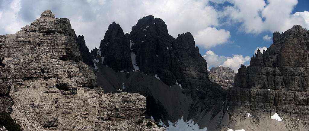
Croda Cimoliana and Monfalcon di Montanaia from southeast - Photoandrea
The normal route is placed along its eastern side, inside a beautiful natural gravelled basin surrounded by towers and cliffs. It is called: Cadinùt di Cimoliana. From the top is visible the whole group of Monfalconi and Spalti di Toro. The group also includes the summits: Campanile Stabile (2502m), Croda Cimoliana (2408m), Campanile Pordenone (2310m), Cima Montanaia (2268m), Cima Meluzzo (2188m), Punta Mantica (2500m) and the Cima d'Arade (2503m). It overlooks the "Val Montanaia" to the south side, the "Val d'Arade" to the north side and the "Val Monfalcon di Cimoliana".
Getting there
There are three possible way to climb:
- FromRifugio Padova Val d'Arade path 353
- From biv. Marchi/Granzotto Val Monfalcon di Forni path 349
- FromRifugio Pordenone Val Cimoliana path 349
Road accessFrom East: From the UDINE-TARVISIO motorway exit CARNIA and then Tolmezzo, Villa Santina, Forni di Sopra, Passo della Màuria, Lorenzago and Domegge di Cadore - From the UDINE-TARVISIO motorway exit Gemona and the S.daniele, Maniago, Barcis Cimolais, Rifugio Pordenone
Road access from West: From the BRENNERO motorway exit BRESSANONE/BRIXEN and then Dobbiaco, Cortina d'Ampezzo, Passo 3 Croci, Domegge di Cadore, Lorenzago , Passo della Màuria and Forni di Sopra - From the BRENNERO motorway exit BRESSANONE/BRIXEN and then Dobbiaco, Cortina d'Ampezzo, Longarone, Cimolais, Rifugio Pordenone
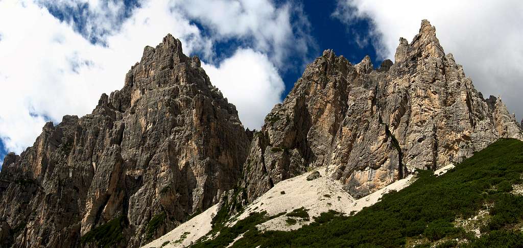
Val d'Arade above the refuge Padova
From South: From Venezia to Belluno, Pieve di Cadore, Domegge di Cadore , Lorenzago, Passo della Màuria and Forni di Sopra Or From Venezia to Belluno and then Longarone, Cimolais, Rifugio Pordenone From North: From Passo di Monte Croce Carnico to Tolmezzo. Villa Santina, Forni di Sopra , Passo della Màuria , Lorenzago and Domegge di Cadore From S.Candido to Passo di Monte Croce Comelico, Domegge di Cadore, Lorenzago di Cadore, Passo della Màuria and Forni di Sopra Or From S.Candido to Passo di Monte Croce Comelico, Longarone, Cimolais, Rifugio Pordenone
Normal Route From ref. Pordenone follow the path 349 to "Forcella Leone" to the junction with the path 348. From the junction, follow the course of the water stream going up on poor track in the direction of the waterfall that originates it on the left, and after a bit, turn right towards a large boulder with little stonepile above.
Now aim the cliff above, the base of which lies the path and follow it to the left, up to a grassy gully and an excellent water source. Climb up the grassy gully that allows you to enter the beautiful and lonely "Cadinut of Cimoliana".
Is now time to stand holding the left, without venturing on the gravel slope (useful instead to return); always continue to rise on plates always keeping to the left until you reach the base of the rocks through the scree towards two large red signal.
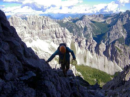
Now the path proceeds in rare red marks and essential stonepiles. Going up the debris of the channel is one of the most challenging steps: a first step of II+ (4m) and a subsequent chimney of 15m of II, following the release of unsafe debris (take care to the stones that will inevitably come in the chimney) .
You proceed now to ledges alternating with fun steps up on the ridge, then switch to side of Val d'Arade and you face the second gentle stretch, a chimney of broken rock, often wet and very exposed (10m , II), after which you goes directly to the summit, 2548m.
Same route for the descent. Helmet is mandatory! Useful a 30m rope for rappeling.
Other routes:
North ridge: From "Forcella Cimoliana", very bad rock (300m II°)
From west: From "Forcella Teresa", most logic route (120m II°)
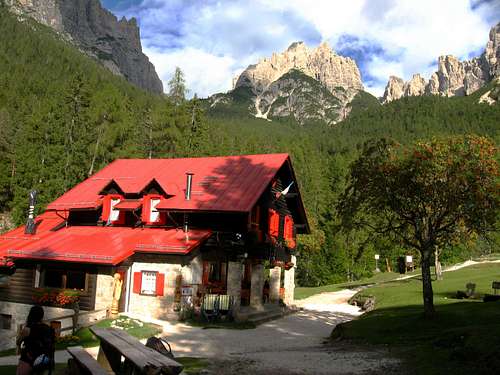
Rifugio Pordenone 1249 m. CAI Sez. Pordenone - Guardian: Marika Freschi Open: from the end of May to the end of September Phone: Hut 0039042787300- Mobile 00393355224961 Getting there: 10 minutes from Pian Meluzzo
Rifugio Padova 1287 m CAI Sez Padova - Guardian: Paolo De Lorenzo Open: 25.04 - 31.10 = 24.12 - 06.01 Hut Phone: 0039043572488 Getting there: by car from Domegge di Cadore across Val Talagona Bivacco Perugini 2060 m - CAI Camposampiero Getting there: from Pian Meluzzo 2.30h.
Maybe the most useful and detailed guidebook of this area, even if very dated, is "Dolomiti Orientali" volume II - Antonio and Camillo Berti - 1982 - Guida dei Monti d'Italia - 25 euro
Children refers to the set of objects that logically fall under a given object. For example, the
Aconcagua mountain page is a child of the 'Aconcagua Group' and the 'Seven Summits.' The
Aconcagua mountain itself has many routes, photos, and trip reports as children.
Parents refers to a larger category under which an object falls. For example, theAconcagua mountain page has the 'Aconcagua Group' and the 'Seven Summits' asparents and is a parent itself to many routes, photos, and Trip Reports.
Related objects are relevant to each other in some way, but they don't form a parent/child relationship. Also, they don't necessarily share the same parent.

 7910 Hits
 85.36% Score
 20 Votes