
-
 5838 Hits
-
 84.27% Score
-
 18 Votes
|
|
Mountain/Rock |
|---|---|
|
|
44.10000°N / 10.23534°E |
|
|
Hiking, Scrambling |
|
|
Spring, Summer, Fall |
|
|
5361 ft / 1634 m |
|
|
Overview
 Monte Focoletta Monte Focoletta |
Monte Focoletta is one of those peaks that you usually overlook. It is located between bigger and more impressive neighbours and though it is small in size its summit is difficult to get to. Its northern base is visited fairly often, as Via Vandelli, an 18th century mountain "road" runs across the NS-ridge of the Alpi Apuane just several hundred metres away, across Passo della Tambura. The road and the pass are the easiest way to reach Monte Tambura, the second highest mountain of the range. to the south - at a similar distance - you find Alto di Sella, one of the large marble mountains, with quarries high up in its west face.
 |  |  |
Between 1738 and 1751 the Prince of Modena demanded a road to be built from his home to his property near the Tyrhenean Sea. Due to political complications the road had to built on the prince's property, which forced his engineer, the abbot Domenico Vandelli, to build it across the saddle of Passo della Tambura. Unfortunately the slopes on both sides are very steep so that it took all his engineering science to construct the endless switchbacks which lead across the pass. However, the prince's coach proved to large for the switchbacks which drove Vandelli into suicide.
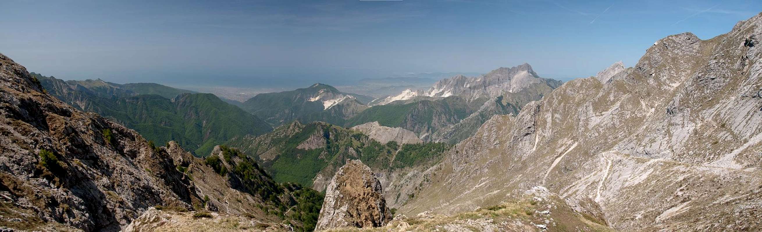  |
Wedged between these two large mountains, Monte Focoletta almost vanishes, when sen from their summits. However, it is a wonderful lookout peak, thanks to the reverse view and the western view towards the Tyrrhenean Sea and the eastern one towards the Appenines. While 95% of the ascent are very easy, following either side of Via Vandelli, the final 150m are rather difficult. On three sides Monte Focoletta displays near vertical walls and only the approach from the northern side is possible. You pass through Passo della Tambura and scramble up a scree slope towards the exposed north ridge of the mountain. A first gendarme has to be passed on the western side, a second one to the east. From there a UIAA II scramble takes you to the round top of Monte Focoletta. From the south there is also a possible route, which requires UIAA III or IV skills.
 |  |  |
The mountain - like all summits on the ridge between Alto di Sella and Monte Tambura was fortified during the last days of WW II, when the Alpi Apuane were among the last frontlines on Italian ground. To both sides of the strategic Passo della Tambura you find former artillery positions, it is not clear whether they were built by German or Allied soldiers. Most likely the "path" to the summit dates back to this period.
Getting There
 The upper Via Vandelli
There are two reasonable trailheads for Monte Focoletta, at both sides of the 18th century Via Vandelli. The eastern ascent starts near Vagli di Sopra, the western one near Rescetto
- Vagli di Sopra Trailhead:
- From Pisa or Firenze (Florence) take motorway A11 to Lucca
- Switch to SS12 in direction Abetone
- At Borgo a Mozzano switch to SP2
- At Castelnuovo di Gafagnana switch to SS445, direction Aulla
- At Poggio follow the signs to Vagli di Sotto
- Drive by Lago di Vagli on the northern shore and head for Vagli di Sopra
- Drive through the village and follow the signs Cave di Marmo
- Park your car before entering the marble quarries.
- Rescetto Trailhead:
- From Firenze (Florence) take motorway A11 to Lucca and Viareggio
- Switch to A12 north
- At the exit Massa turn off and drive through the town centre
- Follow the signs to Castagnetola, Cagliegliaand Rescetto
- Park your car at the end of the road.
Red Tape
 Monte Tambura seen from Monte Focoletta
The Parco Naturale delle Alpi Apuane was established in 1985 to protect the nature as well as culture of the area within which the Alpi Apuane are located. Its overall size amounts to almos 21000 ha. A constant challenge is the presence of roughly 300 marble quarries which their impact on the environment. A hiker might easily find himself inside one of the quarries and is requested to follow signs and rules there.
The park's official website
Accommodation
 Monte Focoletta beneath Alto di Sella
Accommodation is relatively easy to find along the coast of the Tyrrhenean Sea. Viareggio, Massa, Carrara and La Spezia offer lots of hotel rooms as well as campgrounds. Either book them by travel office or go for a google search.
On the other hand, to stay closer or within the range you can make use of Agriturismo, farms, which offer food and lodging. The site of the Natural Park has a selection of all kinds of accommodation of the area:
Weather Conditions
Maps & Books
Maps
- Alpi Apuane - Garfagnana
Kompass Verlag
1:50000
ISBN: 3-85491-852-6
- Geological Map Parco delle Alpi Apuane
1:50000
L. Carmignani, P. Conti, L. Disperati, P.L. Fantozzi, G. Giglia and M. Meccheri
Maps Online
Books
- Tuscany North / Toskana Nord
Wolfgang Heitzmann / Renate Gabriel (translation: Gill Round)
Rother Verlag
ISBN: 978-3-7633-4812-1 (English)
ISBN: 978-3-7633-4115-3 (German)
- Guida al Parco delle Alpi Apuane
Edited by: Giuliano Valdes
Series: Guide Felici
ISBN: 88-88327-91-6
- Guida all’Alta Via del Parco delle Alpi Apuane
Angelo Nerli
Felici Editore Srl
ISBN: 88-6019-006-1