
-
 23497 Hits
-
 83.69% Score
-
 17 Votes
|
|
Mountain/Rock |
|---|---|
|
|
44.03744°N / 10.32346°E |
|
|
Hiking, Scrambling, Skiing |
|
|
Spring, Summer, Fall, Winter |
|
|
6096 ft / 1858 m |
|
|
Overview
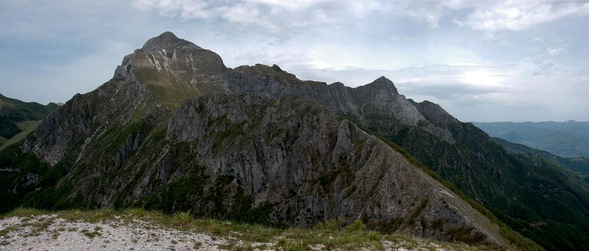
 Pania Secca and Pania della Croce seen from Monte Sumbra Pania Secca and Pania della Croce seen from Monte Sumbra |
Together with its direct neighbour, Pania Secca, Pania della Croce stands out as one of the most visible mountains of the Alpi Apuane in Italy's Toscana (Tuscany) region. It forms a barrier, separating the northern main summits of the group from the lower karst-like hillcountry in the south. Two valleys, Val Torente Turrite Secca in the north and Val Torente Turrite di Gallicano in the south separate the two mountains from their surroundings, ensuring that on both sides the elevation difference is more than 1000m.
 |  |  |
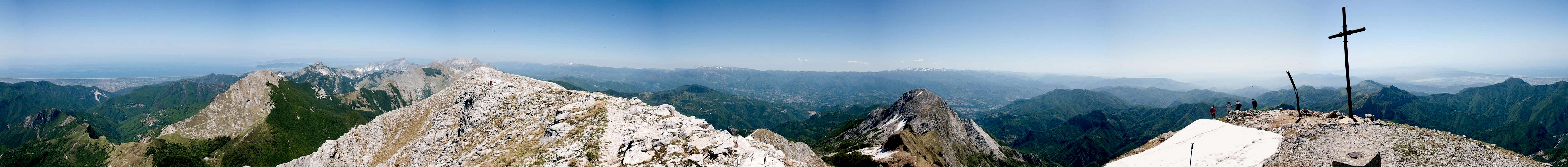
Though not the highest summit of the Alpi Apuane, - Pania della Croce comes in on place four - the mountain can be called the trademark or signature mountain of the range. Visible from all sides around, itself it is one of the best lookouts of the Alpi Apuane, thanks to its separated location. Only the views from Pania Secca can rival the ones from Pania della Croce with the full view of the Apuane and the whole main ridge of the Appennino Tosco-Emiliano to the east. And of course the Tyrrhenean Sea seems only a few feet away.
  |
This makes Pania della Croce one of the most popular mountains of the Apuane, a fact to be seen by the multiple routes which lead to its summit. There are three (!) refuges in its direct vicinity, which in summer cater to the summit aspirants. The routes from the two valleys are very long and tiring and the west and south faces can be challenging. However, the normal route is a short scramble which starts at the chapel of Piglionico, halfway up the mountain (1127m) and can be done in as little as two hours. It follows a steep scree couloir to the east of the mountain, which also proves to be challenging, especially if you have to leave the main path (which can happen in spring due to remaining snow fields). All routes combine on the north risge of the mountain, about 50m beneath the summit which then can be reached by a short and somewhat exposed hike.
 Uomo Morto, the face of the Dead Man
A curiosity can be seen between Pania della Croce and Pania Secca: there Uomo Morto, the face of the dead man lies looking up at the sky. The features - nose, lips and chin - are visible from both north and south, though they look slightly different. On the north ridge of Pania della Croce you find another summit, Pizzo delle Saette, the Lighning Peak, the name of which indicates that the mountains in this area kind of attract thunderstorms. It is wise to climb them during the mornings to be back again when afternoon thunderstorms sweep the summits.
360° Summit Panorama
 |
Getting There
 |  |  |
- West: From Forte dei Marmi on the coast of the Tyrrhenean Sea:
- Take SP9 through Seravezza
- At Pontestazzemese turn left to Cardoso or Pruno (1400m elevation gain)
- Take SP9 through Seravezza
- North: From Massa on the coast
- Take SP5 to Passo del Vestito
- Take SP13 into Val Torrente Turrite Secca
- Trailheads are Localita Tre Fiumi or Isola Santa (intersection with the road from Seravezza, 1100m elevation gain)
- Take SP5 to Passo del Vestito
- North: From Castelnuovo Garfagnana
- Take SP12 direction Massa
- Trailheads are at Isola Santa or Tre Fiumi (1100m elevation gain)
- Take SP12 direction Massa
- South: From Gallicano #1
- Take SP39 (signs "Grotta del Vento") westward
- Trailhead is Formovolasco (1400m elevation gain)
- Take SP39 (signs "Grotta del Vento") westward
- North-East: From Gallicano #2
- Take SP41 through Molazzana
- Follow the signs to Alpe San Antonio
- Before you reach the Alpe, follow the signs to Piglonico (elevation gain 700m)
- Take SP41 through Molazzana
Red Tape
 Podarcis tiliguerta, female
The Parco Naturale delle Alpi Apuane was established in 1985 to protect the nature as well as culture of the area within which the Alpi Apuane are located. Its overall size amounts to almos 21000 ha. A constant challenge is the presence of roughly 300 marble quarries which their impact on the environment. A hiker might easily find himself inside one of the quarries and is requested to follow signs and rules there (especially for the start of the western route).
The park's official website
Accommodation
Accommodation is relatively easy to find along the coast of the Tyrrhenean Sea. Viareggio, Massa, Carrara and La Spezia offer lots of hotel rooms as well as campgrounds. Either book them by travel office or go for a google search.On the other hand, to stay closer or within the range you can make use of Agriturismo, farms, which offer food and lodging. The site of the Natural Park has a selection of all kinds of accommodation of the area:
There are three huts near Pania della Croce: Rifugio Rossi at Uomo Morto, Rifugio del Freo at Foce di Mosceta and Rifugio la Fania above Pruno and Cardoso. You can find more information on the Alpi Apuane main page
Weather Conditions
Maps & Books
Maps
- Alpi Apuane - Garfagnana
Kompass Verlag
1:50000
ISBN: 3-85491-852-6
- Geological Map Parco delle Alpi Apuane
1:50000
L. Carmignani, P. Conti, L. Disperati, P.L. Fantozzi, G. Giglia and M. Meccheri
Maps Online
Books
- Tuscany North / Toskana Nord
Wolfgang Heitzmann / Renate Gabriel (translation: Gill Round)
Rother Verlag
ISBN: 978-3-7633-4812-1 (English)
ISBN: 978-3-7633-4115-3 (German)
- Guida al Parco delle Alpi Apuane
Edited by: Giuliano Valdes
Series: Guide Felici
ISBN: 88-88327-91-6
- Guida all’Alta Via del Parco delle Alpi Apuane
Angelo Nerli
Felici Editore Srl
ISBN: 88-6019-006-1