
-
 9150 Hits
-
 84.82% Score
-
 19 Votes
|
|
Mountain/Rock |
|---|---|
|
|
45.51530°N / 7.33926°E |
|
|
Piemonte |
|
|
Mountaineering, Trad Climbing, Sport Climbing |
|
|
Summer |
|
|
11227 ft / 3422 m |
|
|
Overview
Geographical classification: Western Alps > Graie Alps > Gran Paradiso Group > Gran Paradiso Group Southern Sector > Monte Nero
Monte Nero 3422 m
The area of Piantonetto, a tributary of Valle dell'Orco, is located in the Southern sector of Gran Paradiso Group, a range made of steep granite walls with beautiful rock climbs, both classic and modern. Piantonetto is the rocky heart of Gran Paradiso, and here we find Monte Nero, an attractive pyramid peak - quite rocky - lying in the Subgroup Roccia Viva-Apostoli, a wild and protected milieu fully situated inside the Italian territory, between Valle d'Aosta on the Northern Side and Piemonte (Canavese) on the Southern one. Gran Paradiso main Aostan valleys are Val di Cogne, Valsavarenche and Val di Rhemes, while main Canavese valleys are Valle dell'Orco or Val Locana – with its complex orography and sub-valleys - and Val Soana.


Overlooking the Bivacco "Gino Carpano" with its 400 m. high East Face, Monte Nero is really a lonely and wild peak!!! As a matter of fact, notwithstanding it shows high-quality gneiss as a general rule, maybe in reason of its long approach, Monte Nero is not a crowded peak and just due to this fact mountaineers and climbers can spend here a secluded experience.
The East Face shows a starting steep wall – mightful in the neighbourhood of the route Hasta Siempre – and a powerful summit building, culminating in Monte Nero bicuspidate summit; even if broken in its central part by a short section having some sloping slabs, this cliff is truly a very challenging and satisfactory place to climb.
First ascent: A. Sibille - M. Baretti - T.G. Tarro – A. Sacchi 10-8-1886 along North Ridge and West Side (only A. Sibille climbed the summit)
On the top: a trigonometric signal placed by CAI (Italian Alpine Club) Sez. Rivarolo Canavese.
Getting There

Road Access
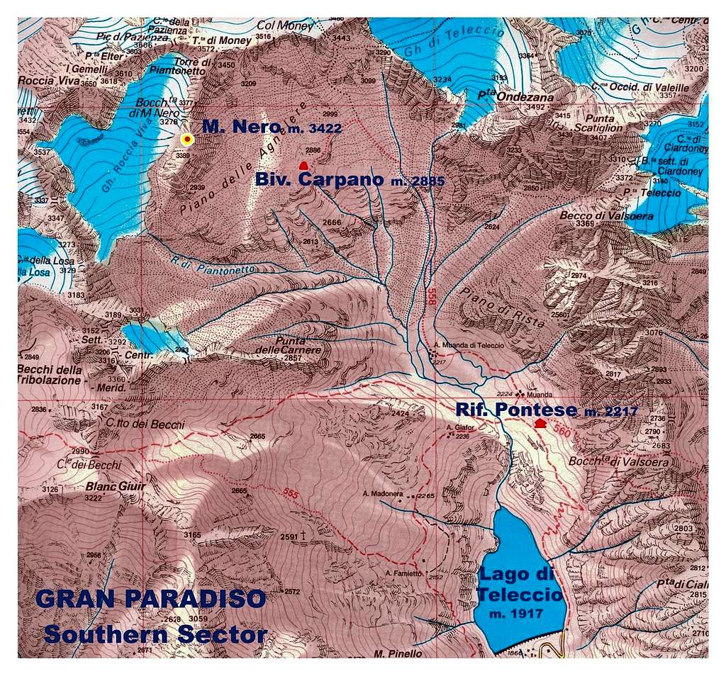
From Turin reach Courgnè and Pont Canavese mt. 461; from here follow Orco Valley as far as Rosone mt. 715 (Km. 16,5 from Pont Canavese). A bit after Rosone leave the main road and follow on the right-hand side the road rising along Piantonetto Valley and reaching Teleccio artificial Lake mt.1917. Parking lot.
Walking Approach
From Teleccio Lake (Ham, artificial lake) follow the road running along the right shore of the lake, then a steep path rising to Pontese Hut (40 minutes from the parking). From here follow a track crossing all the plain (Pian delle Muande). After leaving Teleccio Muanda on the left-hand side, cross some streams; from here there are two different approach ways:
- walk up a large gully on the right hand-side, then cross the gully towards left to reach the bivouac (easier but longer) – 2 hours from Pontese Hut
- climb on the left a steep rocky gully equipped with fixed rope rising straightly to the bivouac - 1,40 hours from Pontese Hut.
Routes overview

Monte Nero routes overview from left to right (French Scale):
- North Ridge and West Side First summiters’ route - North-East Route
EAST FACE
- Via la naja dal cervello TD inf., 300 m. Not equipped
- Direct Route ED, 6b, 350 m. Not equipped
- Man in Black ED inf., 6b+ obbl., 440 mt. Bolts. Necessary friends and nuts
- Hasta Siempre TD sup., 6c, 6a+ obbl. 490 mt. Bolts. Necessary friends and nuts
- Via Volpatto AD sup., 4b 400 mt. Not equipped
- Via Ribaldone D sup., 4c 350 mt. Not equipped.
- South Ridge 400 m.
- South-North Crossing

Red Tape


There are no fees or permits needed to climb Monte Nero. The peak is located inside Parco Nazionale del Gran Paradiso, established in 1922, one of most important National Parks in Italy. You should take care of nature as usual within the boundaries of all the natural parks. Free camping is not allowed and fires are strictly forbidden. The whole fauna and flora are protected. Don’t disturb fauna and other mountaineer's peacefulness with every kind of noise.
Huts and Bivouacs

Rifugio Pontese at the beginning of Pian delle Muande, above the Teleccio reservoir m. 2200 (guarded by “Gran Paradiso Friends” Association) open in summer (40 minutes from Teleccio Lake) - 60 places, 10 in winter-room RIFUGIO PONTESE

Bivacco Gino Carpano m. 2865 (“Turin Young Mountain”) always open. 2 hours from Pontese Hut.
When to climb


Best season goes from June to September
Meteo
Guidebooks and maps


"Rock Paradise – Classic, modern and sportive climbing in Gran Paradiso valleys” by Maurizio Oviglia Ed. Versante Sud 2000
“Gran Paradiso” by E. Andreis, R. Chabod and M.C. Santi Guide dei Monti d’Italia TCI-CAI
Maps


“Gran Paradiso - La Grivola - Cogne” – IGC 101 1:25.000
"Il Parco Nazionale del Gran Paradiso" - IGC 3 1:50.000
External Links
P.N.P. Parco Nazionale del Gran Paradiso