
|
|
Mountain/Rock |
|---|---|
|
|
48.34360°N / 121.1986°W |
|
|
Skagit |
|
|
Mountaineering |
|
|
Spring, Summer, Fall |
|
|
7435 ft / 2266 m |
|
|
De-Misch-tifying
Okay, so before now if you wanted to find useful climbing information on Mount Misch (#5 below), the highest summit in the Buckindy Group, you’d have to consult with Fred Beckey’s green Cascade Alpine Guide. He devotes several pages to the Buckindy Group. In general, his descriptions are pretty accurate. In fact, there were more entries in the registers* than I had anticipated, so he must not have been leading too many people astray. Peaks in the Buckindy Group have been done as a ski traverse going in via Green Mountain and out via Snowking Mountain or visa versa. The Buckindys sit right in the middle. One might even say the Green-Buckindy-Snowking Traverse is the macho (read: more arduous) version of the famed Ptarmigan Traverse, which takes place essentially along the next divide to the east.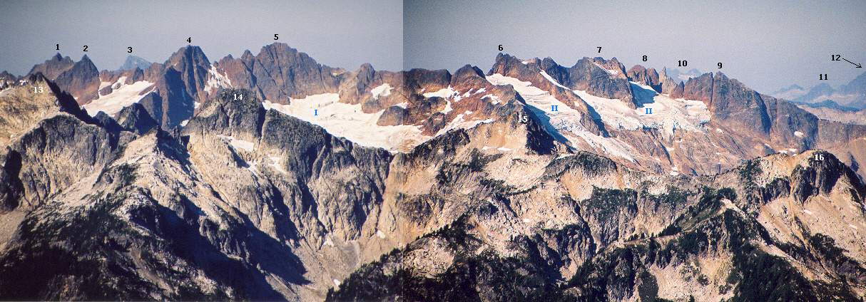
Mount Misch has been on my radar for several years, even before taking on the challenge of climbing all of Washington’s 144 2,000-ft prominence summits, of which Misch comes in at #89 with 2435P. It is the highest point of land west of the South Fork Cascade River and Downey Creek. Yet, it only reaches this stature by a mere two feet over Snowking Mountain, which is seven miles to the northwest. Note: Andy Boos completed the 2000-ft prominence list on Mt. Misch on 0ct. 20, 2010. He was the third to finish the list after John Roper (2001) and Paul Klenke (2008). Martin Shetter finished the list on Mt. Misch too, on Aug. 6, 2011. He is now fourth to finish.
If you look on the (current) USGS map you will not find Mount Misch labeled. This is because the summit, located in a wilderness where it is generally very difficult to get new names applied, wasn’t officially recognized with a bona fide** name until after 1993 (it was still pending as of that year according to Dr. Roper’s register entry). There was a time when the highest point may have been intended to be “Mount Buckindy” but several factors over time migrated the name to the 7320+ crag (once labeled as 7311) 0.7 miles to the NNW. All of this confusion is discussed in Beckey’s book. I might suggest you go there for a better treatment than I could give here. Besides, I’d just be paraphrasing him anyway.
The word “Buckindy” itself is a portmanteau: it referring to the divide between Buck Creek on the south and Kindy Creek on the north. But if you want to be strict, the southern drainage is not the Buck but the Horse, a tributary drainage of Buck. Maybe it should have been called Kindhorse Group. Nope. And then: just as much of the group’s east slope drains to Downey Creek. What about Downhorse Group? Portmanteaus are wild!
The rock of the Buckindy Group sucks! No need to mince words. It’s not like the granodiorite that is nearby. No, it’s like the crap rock on Boston Peak 12 miles to the NNE. Beckey says the rock is mineralized breccia pipe, whatever that is. I do know this, for the standard route, he says there is considerable loose rock in the final gully. Now I’ve been in way too many chossy gullies in my time and this last gully of Misch is right up there in the Top 10.
The first ascent occurred on August 28, 1955 by Donald Grimlund, David Nicholson, and Winslow Trueblood. The last ascent was mine, I can guarantee.
Of course, the Everywhere Man Dr. Roper has been to Misch. Here is his article about the mountain as reported in Pack & Paddle in the 1990's.
* there are currently two registers up there—a sort of ammunition box and a regular Mountaineers brass cylinder register that came later. Lowell Skoog in 1989 suggested, with apparent success, that everyone should only sign in to the latter after his entry since the ammo box is of dubious durability (note, however, that the small memo book inside of it was completely dry and unsoiled by the hand of Mother Nature).
** a group of folks climbed to the top in 1969 (they were the ones who placed the ammo box register, I believe). They suggested the name Mount Margaret Sanger. This name did not stick with the general public. Maybe it stuck for them; but not for us. Beckey suggested the name Mount Misch to honor friend and Cascades geologist Peter Misch. There are even some kind words from Mr. Misch transcribed into the older register at the summit. He said that his friend Fred committed the faux pas of naming a summit after him. I don’t think it was a faux pas in this case.
Getting There
There is a way to get to the Buckindy Group and Mount Misch from the north via a long traverse from Snowking Mountain (by way of Mutchler Peak) but I will not go into that route. Instead, I’ll just provide information for the route from Green Mountain. This is the shortest approach route. Then there is the climbing itself. Yet the climbing, though not lacking in dangerousness, isn’t the exasperating part of the climb. That’s what the approach is for.In the Green Mountain Trail section near the back of his guide, Beckey devotes several paragraphs on getting to the area (he calls it the Mount Buckindy High Route). His description is pretty good for its brevity. But I can give more detail. See here.
For the route up the peak once you get over to it, click here.
Red Tape
The Buckindy Group is in the Glacier Peak Wilderness so leave no trace ethics should be applied. You pass in to the Wilderness once you cross over the south shoulder of Green Mountain. Then there is the Green Mountain Trailhead itself. Do you need a Trail Park Pass for it? There isn’t a toilet facility there so my guess is no.Camping
There are actually quite a few places to camp on the traverse despite the over all steepness of the sidehilling. Here is a listing of viable camps:At the pond in the basin SW of Green Mountain (5200 ft; ample water but use a filter)
On the south shoulder of Green Mountain or just north of there in the shallow basin (6100 ft; melt snow for water)
In an open area east of Pt. 6082 (5600 ft; water may be scarce in late season)
In a flat area below and east of Lake 5371 (5260 ft, excellent water flowing out of the lake; picture)
On the other side of the SE divide of Pk 6675 (5600 ft; ample water but use a filter)
Near the saddle above Horse Lake (5500 ft; there was a stagnant pool there that definitely would require a filter)
In the basin WSW of Misch (5200 ft; good running water from snow; there is a little lake there too)
When to Climb
You could climb Mount Misch practically any time of year. The traverse across all the steep, vegetated slopes would surely be easier when snowcovered. But hard snow has its own attendant run-out dangers. Access up the Suiattle River Road is good practically all year except for during the worst freezes. The Green Mountain trailhead junctions off of the river road at a relatively low 1400 ft elevation.As for the climbing of Misch itself, snow in the gullies might be a good thing because it will cover all that loose rock. But snow in the gullies amplifies the seriousness of the lack of run out.
When would I not climb Mt. Misch? I would not climb Misch if there’s any chance of rain for the approach from Green Mountain or if it will have been raining. All those open slopes: if their treacherousness doesn’t get you, your feet will at least be soaked from all the moisture sloughing off onto your pant legs. Gore-Tex rain pants come highly recommended!
Mountain Conditions
Localized Mountain ForecastDarrington Forecast (nearest town)