
-
 31801 Hits
-
 90.72% Score
-
 33 Votes
|
|
Mountain/Rock |
|---|---|
|
|
45.04800°N / 109.526°W |
|
|
Hiking, Mountaineering, Scrambling, Skiing |
|
|
Spring, Summer, Fall, Winter |
|
|
12204 ft / 3720 m |
|
|
Overview
Mount Rearguard is the highest point on the massive Hellroaring Plateau in Montana's Beartooth Mountain Range, and one of only 27 ranked peaks in the state to rise over 12,000 feet. The peak can be accessed from a number of different directions, with the easiest routes being nothing more than an off trail hike. Excellent ski descents can be found from Rearguard during the Winter and Spring months. Mount Rearguard made the news in August of 1998, when a small aircraft crashed into the western slopes of the mountain at approximately 11,900 feet, killing the pilot. The plane was thought to be traveling from Wells Nevada to Minot North Dakota.
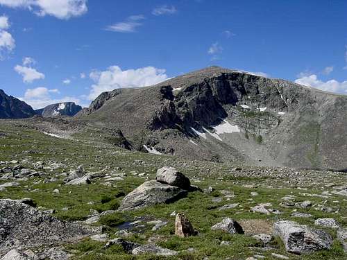 Mt. Rearguard Mt. Rearguard | 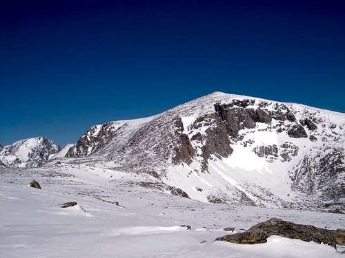 Mount Rearguard in Winter Mount Rearguard in Winter |
Getting There
Trailhead
Rock Creek Trailhead
This is the standard trailhead for the Spirit Mountain group which includes Mount Rearguard. From the Montana Road 308 and US Highway 212 junction in Red Lodge, go west on US 212 for 11.4 miles and turn right onto FS 2421 (Rock Creek Road) and measure from this point. Follow this paved road for 0.9 miles where it turns to dirt and passing by three National Forest campgrounds. Here the road forks, take the left fork and continue on the good dirt and pass the M-K Campground at mile 2.8. Here the road becomes rougher. Continue 8 miles on this road as it drops into Wyoming and reaches the trailhead at the Montana/Wyoming state boundary at 8,700 feet. This road is passable for tough passenger cars with good ground clearance. There are many good places to pull off and camp.
Approach
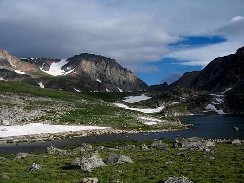
This is one of the shortest approaches to any 12,000 foot peak in the Beartooth Mountains. From the Rock Creek trailhead, begin up the steep switchbacking trail through an old burn area and reach a nice footbridge crossing Rock Creek after 0.6 mile at 9,080 feet. Cross the bridge and continue up the trail for eight more switchbacks and locate a side trail heading off to the right (north) at 9,230 feet. There may be a cairn here to mark the turnoff. Follow this steep but well traveled boot path along the left (west) side of Rock Creek for 0.35 mile to where it crosses back to the east side of the creek on large boulders at 9,600 feet. Past this crossing the slope eases and the path continues through open grass above and on the right side of the creek. Continue to a small tarn at 9,820 feet and cross the stream again just below it. Follow the path around the left side of the tarn and pass a very shallow second tarn. Cross back to the other side of the stream and ascend 250 feet along the stream draining Shelf Lake and reach the southwest arm of the large lake at 10,200 feet. Fantastic camping and fishing is found at Shelf Lake.
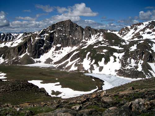
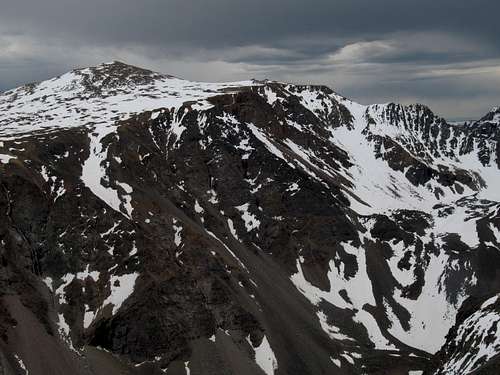 NW face of Mount Rearguard from Thunder Mountain NW face of Mount Rearguard from Thunder Mountain | 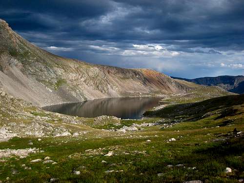 Shelf Lake Shelf Lake |
Route Options
South Slopes - Class 2
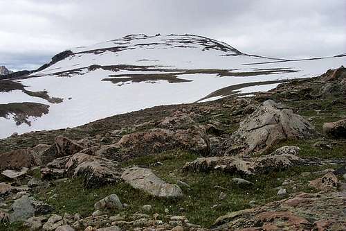
This is the standard route for Mount Rearguard and also is one of the few routes up one of the 12,000 foot peaks that is more feasible as a day hike. Use the Rock Creek Approach and locate the easy slopes about a quarter mile before the tarn at 9,850 feet. Begin hiking northeast up the grassy slopes and after 0.5 mile reach Point 10,670 where the terrain becomes flat. You are now on the Hellroaring Plateau. If there is any hint of bad weather, it’s best to turn around. Walk north on grass across a flat bench and continue hiking up to 11,100 feet to the next flat bench, 0.5 mile from Point 10,670. Traverse on grass around a couple unnamed points to the right (northeast) staying at the 11,100 foot contour for 1.1 miles. When the slope steepens again, climb 0.8 mile north up large talus blocks to the summit. Sliderock Lake can be seen to the east and is a spectacular sight.
RT Distance from Trailhead - 10.5 miles
 Hiking up the South Slopes Hiking up the South Slopes | 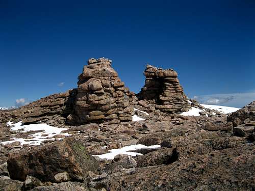 Summit Towers on Mount Rearguard Summit Towers on Mount Rearguard |
West Ridge - Class 2+
Use the Rock Creek approach and hike 1.9 miles to Shelf Lake. From the south end of the lake, hike around its left (west) side on grass and cross its outlet stream. Continue north over a large broad grassy bench with pleasant hiking and reach the southeast corner of Moon Lake after 1.3 miles at 10,400 feet. Walk around the right (east and north) sides of the lake and continue a short ways up the valley to 10,500 feet and locate a large, orange colored talus slope to the right (north) which is 0.7 mile from the southeast corner. Climb this 1,100 foot slope to the north staying to the right side on more solid rock. Reach a small saddle at 11,590. From here turn right and head up the broad west ridge on talus and reach the summit plateau where the slope eases at 11,830 feet. Hike east on boulders across the plateau for 0.5 mile to the summit which is the southernmost point. The rock towers just to the north are actually quite technical and offer a nice challenge for some added adventure. The views of Spirit Mountain’s east face are stunning. Descend either the way you came or make a loop and descend the standard South Slopes.
RT Distance:
From camp at Shelf Lake – 8.2 miles
From trailhead – 12 miles
 Shelf Lake with the west ridge up to the right Shelf Lake with the west ridge up to the right | 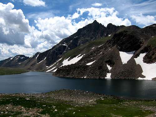 Looking back across Moon Lake Looking back across Moon Lake |
Classy Girls 5.11a
This is a real adventure route offering a challenging, alpine rock climb on the flanks of the Hellroaring Plateau above Hairpin Lake. It's hard to determine how many ascents this route has seen but it it probably less than 10. The approach begins at the Hellroaring Plateau Trailhead reached by a 9 mile long 4WD road that starts shortly after the pavement ends on the Rock Creek Road. Instead of turning left to stay on the road following Rock Creek, continue straight and follow the rougher road as it climbs steadily and switchbacks up above treeline reaching the plateau. At the end of the road 10 miles from Highway 212, there is a trail that heads west. Follow this trail for about 1 mile where you will be able to clearly see Hairpin Lake and the Hairpin Buttress to the north. Descend north and traverse across the valley, passing Snowbank Lake on the way to Hairpin Lake. Stay on the left side of Hairpin Lake and low on the talus field. Follow grassy meadows up the hill and navigate the talus field to the base of the climb. The climb starts on the left side of the wall about 4 miles from the trailhead.
Pitch 1 - 5.10b - 125 feet
Begin climbing up the obvious right facing crack on easy stacked boulders to a flaring offwidth. Pass this offwidth section and move right below a roof where you'll find good gear. Continue left of the roof to a good belay ledge below the roof. A 5.9 variation climb starts 15 feet to the left of the 5.10b start. Follow a left facing crack to an intermittent flake system to a right facing flake with decent but tricky gear and finish on the same belay ledge. This first pitch has a PG-13 protection rating for either variation.
Pitch 2 - 5.10d - 125 feet
Start to the right of the big roof below an inverted staircase type feature. Start on a difficult move with good gear to a ledge. Continue up the broken face to a left facing hand crack to an offwidth. Belay off a good ledge at the base of a huge basaltic sill.
Pitch 3 - 5.11a - ~150 feet
Gain an obvious splitter crack just above the belay ledge and climb through the roof to a dihedral then pull the dihedral to another splitter finger-thin hands crack. Follow the crack until it ends then escape right of the roof and follow interesting pinches to yet another bodacious ledge where you can set up a belay.
Pitch 4 - 5.9 - 125 feet
Climb out of the belay ledge and wander right to an obvious vertical broken hand crack with good gear. Loose rocks are unavoidable so wear helmets! Top out and belay from the boulder field.
Descend by either hiking north along the top of the formation and down the rib with a glacial lake to the left and the Hairpin Lake valley to the right. This rib has some fun scrambling and exposure. Reach the outlet stream and follow along it down moderate slabs and talus back to the north end of Hairpin Lake. This descent is shown on the map below as the dashed red line.
 Classy Girls Route Topo
Map
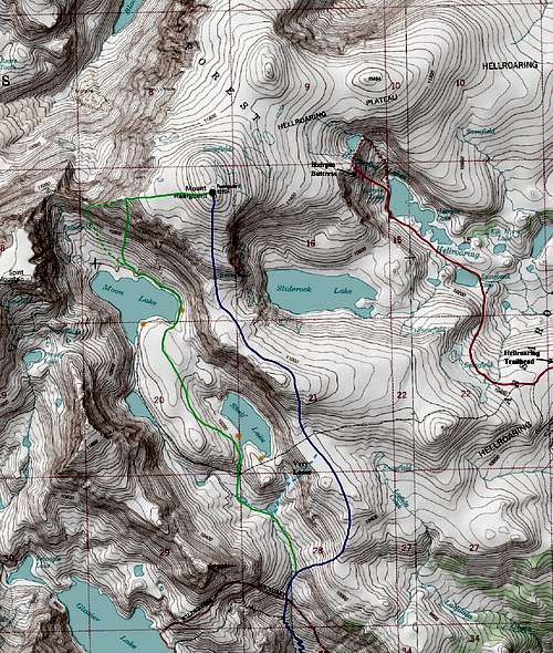
BLUE: South Slopes Standard Route - Class 2
DASHED LIGHT BLUE: South Slopes Shortcut (Very Loose) - Class 2+
GREEN: West Ridge Route - Class 2
DASHED GREEN: Direct West Ridge Variation - Class 2+
RED: Classy Girls (Hairpin Buttress) Climb - Class 5.11a
ORANGE DOTS: Excellent camping spots
Camping/Red Tape
Camping is allowed anywhere within the Absaroka-Beartooth Wilderness. There are several excellent camping spots accessible by car along the Rock Creek Road in addition to the official National Forest campgrounds. Great backcountry camping is also found at Shelf Lake and Moon Lake. Mount Rearguard is located in the Absaroka-Beartooth Wilderness, which is part of the Custer National Forest. No fees are required to climb or camp. No mechanized vehicles are allowed and practice leave no trace.
When to Climb
Summer climbing season is short in Montana with the best time to climb being late July through early September. However, expect some snow on the mountain any time of the year and expect any type of weather. Violent thunderstorms are a common daily occurrence and these storms can also drop snow in August so come prepared with rain gear and insulating clothing. Get an early start to avoid afternoon thunderstorms as they develop very fast and tend to come from the south or west.
Rearguard can be climbed in the winter from either the Rock Creek or Lake Fork drainage. The Lake Fork Road is closed with a gate about 0.5 miles from Highway 212 in the winter. The road up Rock Creek is never officially closed however in mid-winter, it is likely covered in enough snow to require a snowmobile. Depending on snow conditions though you may be able to get within two or three miles of the trailhead especially in late fall or early winter. You are advised to contact the Beartooth Ranger Station at (406) 446-2103 for the latest conditions and road closure information.
 Metcalf Mountain from the South Slopes
External Links
Mountain Project description for Classy Girls 5.11a
My Trip Report and more photos