
-
 34922 Hits
-
 93.04% Score
-
 41 Votes
|
|
Mountain/Rock |
|---|---|
|
|
45.04000°N / 109.55°W |
|
|
12283 ft / 3744 m |
|
|
Overview
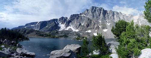
Spirit Mountain is a beautiful peak located in the Beartooth Mountains of South-Central Montana. It is one of Montana's 27 ranked peaks which rise over 12,000 feet, coming in at number 17. A variety of moderate to difficult snow and ice climbs can be found on the North, East, and South sides of the peak from late fall to early summer. A couple of these routes, including the permanent snow fields leading up the South Face from Frosty Lake and the ones coming up from the Black Canyon Drainage between Spirit Mountain and Peak 12,115 (aka. Drop Off Mountain) can be climbed year round. The standard approach for Spirit Mountain is one of the shortest approaches to a 12,000 foot peak in the Beartooths when the Rock Creek Road is open.
The incredible scenery of the area is due principally to the action of glaciation beginning about 1.6 million years ago which carved out the large glacial valleys from the immense high plateau of the Beartooth Uplift. In the process, several high, flat topped peaks which were not completely affected by the glaciation were left behind which dominate the summit views from Spirit Mountain.
The climbing potential on this peak is probably one of the best is the entire Beartooth Mountain range. The east face is one of the biggest mountain faces in the state of Montana and offers ambitious climbers plenty of first or second ascent potential. One feature in particular is the deep cleft bisecting the east face offering very steep snow/ice/mixed climbing in the spring and fall.
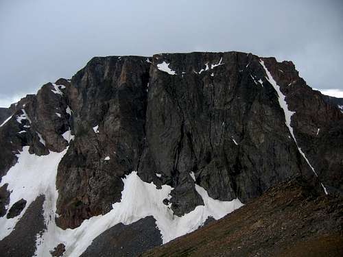
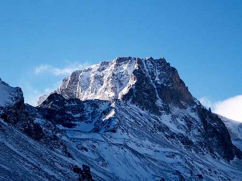 Spirit Mountain in Winter | 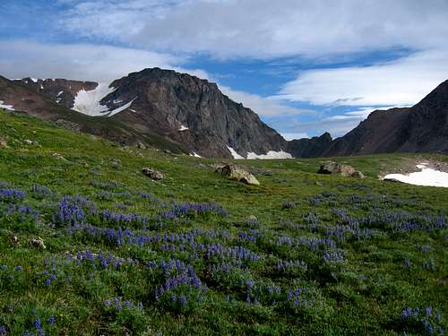 Spirit Mountain with the east face to the right | 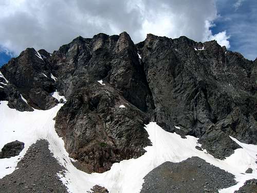 East Face of Spirit Mountain |
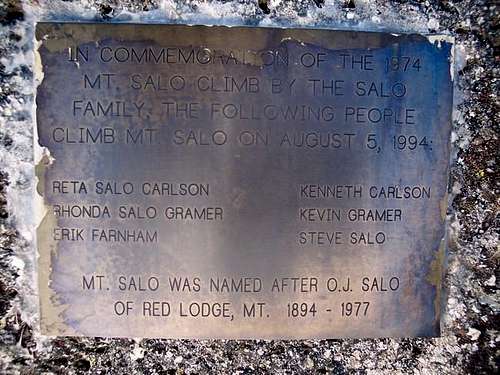
History of the Mt. Salo Plaque
The USGS officially names this peak Spirit Mountain however the Salo Family took it upon themselves to place a plaque atop the summit proclaiming it to be Mount Salo. The plaque on the summit boulder used to read:
In commemoration of the 1974 Mt. Salo climb by the Salo family, the following people climb Mt. Salo on August 5, 1994:Reta Salo Carlson, Kenneth Carlson, Rhonda Salo Gramer, Kevin Gramer, Erik Farnham, Steve Salo
Mt. Salo was named after O.J. Salo of Red Lodge, MT 1894-1977
Otto Jalmer Salo was born on the October 25th, 1894 in Carbon County Montana. He lived in the vicinity of the Beartooth mountains throughout his life, passing away at the age of 82 in Deer Lodge. You can find out more about his family tree here: Otto Jalmer Salo
It is one thing to try to overthrow the official name of a peak, but in this case it seems that the Salo family may not know which peak is indeed named after them. Peak 12,250+, commonly known as Salo Mountain, and now more often called Darlene Mountain is located approximately 0.6 miles WSW of Castle Rock Mountain, or over 7 Miles Northwest of the plaque atop Spirit Mountain. Since then though, the plaque was removed on August 29th, 2005.The USFS has policies against unauthorized placement of plaques and other mementos in wilderness areas. The plaque was clearly not authorized, and was removed by an anonymous party. In response to an E-mail to the Custer National Forest questioning their policies, I got a call from a ranger who would have hiked in and removed it herself. She was glad to be notified, as the ranger district was not aware of the plaque's existence. She commented that if people find similar mementos, they should let the appropriate national forest know and they will send someone to remove them (or you can remove them yourselves). It should be pretty obvious if a plaque is official, and there are very few such memorials in Wilderness areas.
Thanks to member Brice Neugebauer for the information in this section.
The Salo Plaque that once sat on the summit
Getting There
Trailheads
Rock Creek Trailhead
This is the standard trailhead for Spirit Mountain and the one used for the Standard South Ridge route, the South Slopes route and potential routes on the East Face. This approach can also be used for the Northwest Ridge and Dark Moon Couloir routes. From the Montana Road 308 and US Highway 212 junction in Red Lodge, go west on US 212 for 11.4 miles and turn right onto FS 2421 (Rock Creek Road) and measure from this point. Follow this paved road for 0.9 miles where it turns to dirt and passing by three National Forest campgrounds. Here the road forks, take the left fork and continue on the good dirt and pass the M-K Campground at mile 2.8. Here the road becomes rougher. Continue 8 miles on this road as it drops into Wyoming and reaches the trailhead at the Montana/Wyoming state boundary at 8,700 feet. This road is passable for tough passenger cars with good ground clearance. There are many good places to pull off and camp.
Lake Fork Trailhead
Use this trailhead for approaching the north side of Spirit Mountain which includes potential routes on the north face and possibly the Northwest Ridge and Dark Moon Couloir (although it's shorter to use the Rock Creek Trailhead). From the Montana State 308 and US Highway 212 junction in Red Lodge, go 10.8 miles west on US 212 towards Beartooth Pass and turn right onto the Lake Fork Road. Go 1.8 miles on this paved road to its end at the trailhead with ample parking. The elevation at this trailhead is 7200 feet.
Approaches
Rock Creek Approach
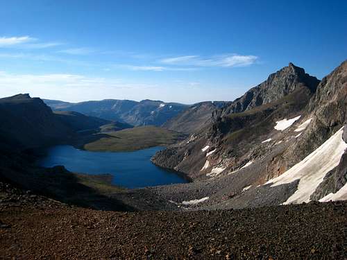
This is one of the shortest approaches to any 12,000 foot peak in the Beartooth Mountains and the standard approach for Spirit Mountain. There are two variations for this approach based on which route you want to do. For the Standard South Ridge Route it's very easy. Simply hike the very well defined Glacier Lake Trail for 2 miles to Glacier Lake. This is a very popular day hike in the summer among families and fishermen.
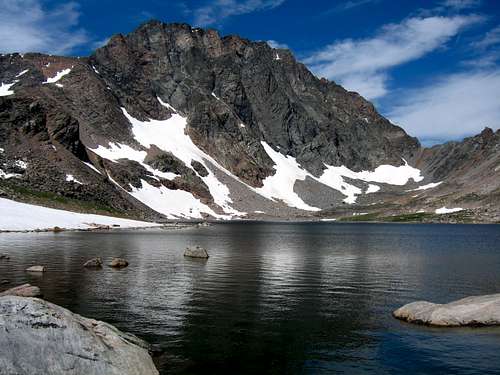
For any other route on the peak except the North Face, use this variation which heads up to the Shelf and Moon Lakes basin. From the Rock Creek trailhead, begin up the steep switch-backing trail through an old burn area and reach a nice footbridge crossing Rock Creek after 0.6 mile at 9,080 feet. Cross the bridge and continue up the trail for eight more switchbacks and locate a side trail heading off to the right (north) at 9,230 feet, a quarter mile from the bridge. There may a cairn here to mark the turnoff but don't expect one. Follow this steep but well traveled boot path along the left (west) side of this side creek for 0.35 mile to where it crosses back to the east side of the creek on large boulders at 9,600 feet. Past this crossing the slope eases and the path continues through open grass above and on the right side of the creek. The trail can be hard to follow at times but follow it to a small tarn at 9,850 feet where it once again crosses the creek back to the west side. Continue up another couple hundred feet on open grass to Shelf Lake which makes an excellent place to camp or continue around the left (west) side of Shelf Lake and continue northwest over a large, broad grassy bench for 1.2 miles to the southwest corner of Moon Lake where you can also camp. It's about 3.2 miles from the Rock Creek Trailhead to Moon Lake with slightly over 1,500 feet of elevation gain.
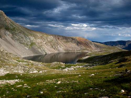 Shelf Lake | 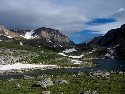 Spirit Mountain from Shelf Lake |
Lake Fork Approach
This approach is much longer and more tedious but makes for a more scenic tour. From the Lake Fork Rock Creek trailhead, follow the trail along the south side of the creek for 4.7 miles to the junction with the Lost Lake trail. This spur trail leads 0.2 miles to Lost Lake with good camping, but poor fishing. Lost Lake sees a lot of day hikers so don’t expect much solitude here. Continue past the junction 0.3 miles to the nice foot bridge crossing the Lake Fork at 8440 feet. Do not cross the bridge but locate another trail to the left heading south towards Black Canyon Lake. This boot path starts out nice as it passes by some great camping areas but quickly degrades after 0.2 miles. Follow this trail as it weaves through the trees and is often muddy. It can be difficult to follow but it’s worn in enough to locate. When the trail meets Black Canyon Creek, it follows on its left (southeast) side along the rim of the small gorge for 0.2 miles to where the canyon opens up. It is best to cross the creek here on large boulders and catch the path on the northwest side of the creek as it heads through trees for a quarter mile to the base of the head wall at the upper end of the valley. Don’t switchback up to the left on the talus. This just ends and leaves you a lot of rock hopping above the valley bottom on very large rocks. At the head of the valley, the creek disappears under large talus and cairns mark the trail up the head wall to the left (south) in an avalanche chute and around large talus blocks reaching the north end of Black Canyon Lake, at 9220 feet, after another quarter mile. This point is two miles from the Lake Fork Trail. Camping at Black Canyon Lake is sparse but the fishing is superb with very large Yellowstone Cutthroat trout.
 Spirit on the left from Black Canyon Lake | 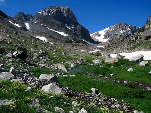 North side of Spirit Mountain |
Route Options
Standard South Ridge - Class 2
This route is simple and offers a beautiful peak hike requiring no special gear in summer. Use the Glacier Lake Trail approach and hike on faint boot paths around the right (north) side of Glacier Lake and continue around the south side of Triangle Lake to Sheep Lake at 10,040 feet. Begin hiking up the rib to the west (left) side of Sheep Lake towards the broad south ridge. Reach the ridge around 11,400 feet and hike 2 miles northward along the easy boulder covered ridge/plateau to the summit. This route is 13-14 miles round-trip and makes an excellent full day hike.
Glacier Lake
South Slopes - Class 2+ and Moderate Snow
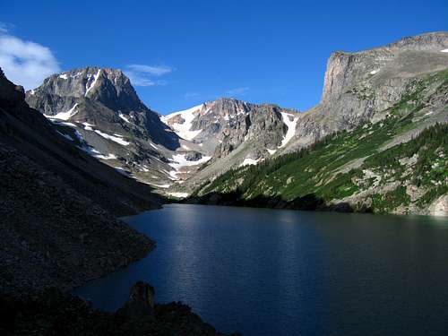
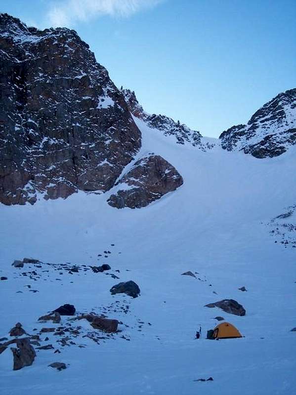
"Cross the Moon Lake outlet stream on a series of rocks and immediately start climbing up the talus and grass slope to the west. This 600 foot slope holds moderate and steep snow in many places well into the summer. Reach the top of this 600 foot slope at 11,000 feet, 0.3 mile from Moon Lake. Continue west up a small valley and contour north at 11,000 feet for 0.1 mile to a very small tarn at 11,050 feet. Walk around its south side and hike up the small head wall for 100 feet reaching a small ridge separating this tarn from Frosty Lake. Contour 150 feet above and to the north of Frosty Lake, cross a small but very loose rocky rib and reach the south slopes permanent snowfield at 11,240 feet. Climb up the snow for 1,000 feet directly to the summit plateau. It starts at about 25 degrees but quickly steepens to 35 degrees for the majority of the climb. The final 200 feet become steep and there is usually a cornice at the top that can be avoided to the right (east) edge of the snowfield on a 60 foot loose rock ridge that leads to the summit plateau (Class 3). Although this will bypass the cornice, beware that the rock is very loose and there is plenty of exposure on the south side to the right. When you reach the summit plateau, walk 0.2 mile east to the highest point at the southeast corner of the plateau." - From my corresponding linked route page
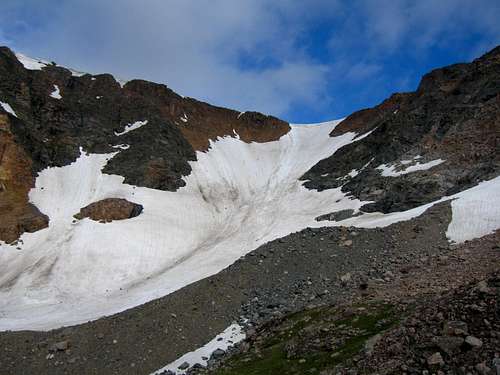 The South Slopes Snowfield | 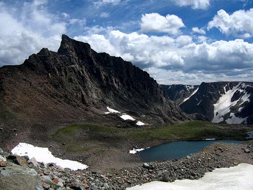 Frosty Lake and Metcalf from the base of the snow |
"This route is a fun alternative to the standard south slopes which involves a beautiful, solid ridge scramble with a few sections of low 5th class climbing making a rope advised if your party is planning to do the direct ridge route. There is a bypass route which allows you to skip the upper 5th class step keeping the entire route at sustained 4th class, therefore making a rope unnecessary for experienced climbers however many people will probably want some protection throughout the route as the exposure is quite relentless much of the way. It's best to climb this route from July through early fall when it is dry. If you find yourself in this area in early season, try the Dark Moon Couloir which is an awesome snow climb located just to the left of the ridge. In fact, this couloir is visible most of the way up the ridge!" - From my corresponding linked route page
 Moon Lake from the base of the NE Ridge | 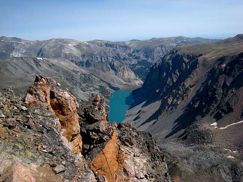 Black Canyon Lake from the NE Ridge |
Dark Moon Couloir - Class 3 and Steep Snow
In early season when the snow coverage is good, instead of hiking all the way to the saddle at the base of the Northwest Ridge, veer left (west) into the steep couloir 200 feet before reaching the 11,250 foot col. Climb the steep, 50 degree couloir for 1,200 feet to the end of the couloir which dumps you on the summit plateau where a short hike south across the plateau takes you to the summit. Be aware that rocks and ice fall down this couloir quite a bit when the warm sun is shining.
 The Dark Moon Couloir from Rearguard | 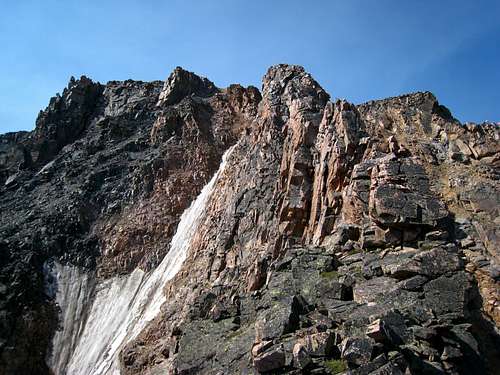 The upper Dark Moon Couloir in bad conditions |
West Slopes via Lake Fork - Class 2 and Moderate Snow
From Black Canyon Lake, hike around the left (SE) side of the lake on rough talus for 1.2 miles staying close to the shore where you may occasionally find a small trail. At the south end of the lake there area couple places to camp. Cross the inlet stream and continue on the right side of the stream up the valley on rough talus or easy snow for 1.5 miles and reach an elevated bench above the valley bottom at 10,200 feet, passing below the Bears Tooth along the way. The intent of this section is to avoid the terminus of the huge rock glacier. Descend 100 feet or so due south passing a tiny tarn at 10,060. Aim for the huge slope leading to the col between Spirit Mountain and Drop-Off Mountain (AKA Forget-Me-Not Mountain). Climb south for 1,700 feet of loose talus or moderate snow (preferred) to the col at 11,720 feet. From the col, it's a very easy hike to the east for 0.75 mile along the plateau boulders to the summit. There is a couple 10-15 foot high rocks on the plateau you'll pass by.
 Spirit Mountain with the West Slopes and route to the col visible as the long talus slope trending rightward | 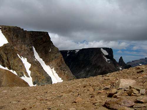 At the col looking to Bears Tooth with the west slopes of Spirit Mountain behind me |
East Face
This face is one of the most prominent big faces in the Beartooths and offers abundant climbing potential. Lunar Arete Route Beta coming soon!
East Face from Moon Lake
Maps
Shown below are a couple maps showing the various routes on Spirit Mountain:
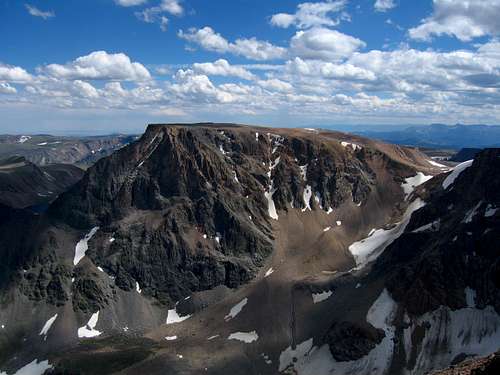
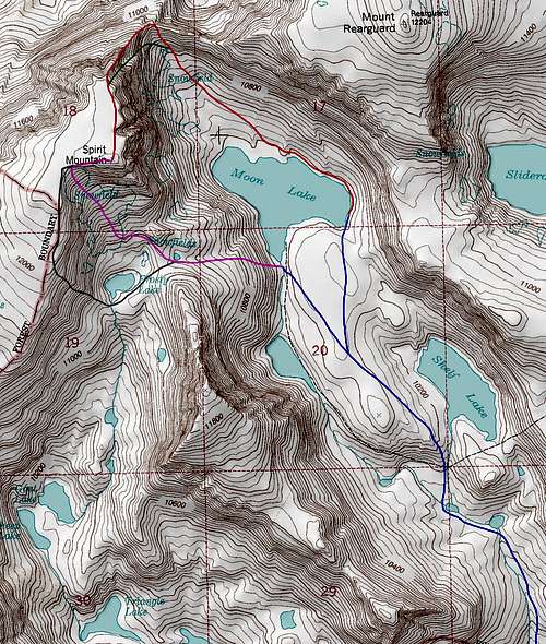 Spirit Mountain Zoom | 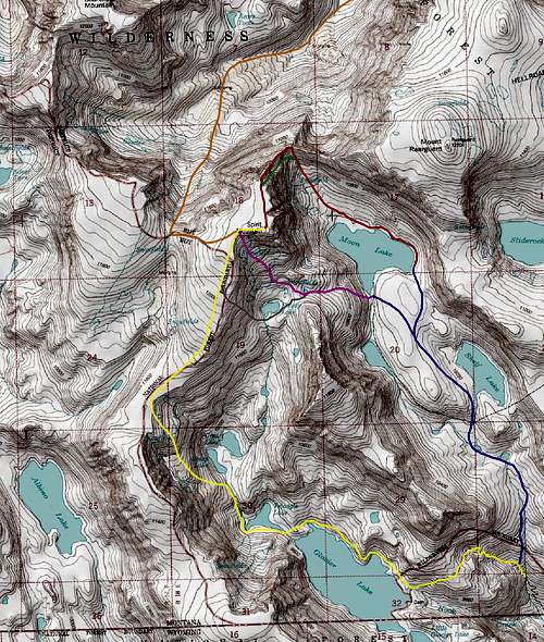 Spirit Mountain Routes Map |
BLUE: Rock Creek/Moon Lake Approach - Class 1
PURPLE: South Slopes standard route - Class 2 Moderate Snow
RED: Northeast Ridge - Class 5.4 or Upper Ridge Bypass - Class 4
GREEN: Dark Moon Couloir - Class 3 Steep Snow
GREY: South Ridge Variation - Class 2+
YELLOW: South Ridge Standard Route - Class 2
ORANGE: West Slopes via Lake Fork - Class 2+ Moderate Snow
Summit View
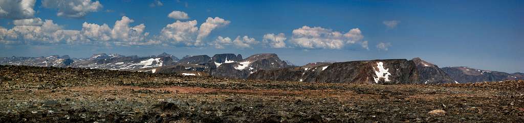
Spirit Mountain summit panorama looking northwest
When To Climb
Summer climbing season is short in Montana. Late July through early September are the months that are most snow-free. However, expect some snow on the mountain any time of the year. Expect any type of weather any time of the year. Violent thunderstorms are a common daily occurrence. Get an early start to avoid afternoon thunderstorms. Storms develop very fast and tend to come from the south or west.Spirit Mountain can be climbed in the winter from either drainage. The road up the Lake Fork valley is closed with a gate approximately 0.5 miles from highway 212 in the winter. The road up Rock Creek, however, is never officially closed. Depending on snow conditions, your vehicle, and your nerves you may be able to get within two or three miles of the trailhead. You are advised to contact the Beartooth Ranger Station at (406) 446-2103 for the latest conditions and road closure information.
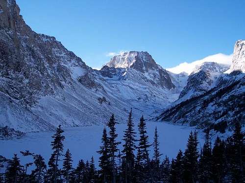 Spirit Mountain in Winter | 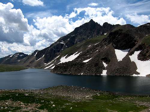 Moon Lake in Summer |
Camping/Red Tape
Camping is allowed anywhere within the Absaroka-Beartooth Wilderness. You are "requested" to check in with the Beartooth Ranger Station in Red Lodge or call (406) 446-2103 before camping in the back-country (although most people do not bother). You must have a permit to cut live trees for firewood. There are several campgrounds along the first paved, then graveled road leading up the Rock Creek drainage. The last official campground (M-K) is four miles from the highway, but additional good dispersed camping spots can be found along the deteriorating road to and including the trailhead. No car-camping areas are available in the Lake Fork Drainage. There is no red tape!
Camp on Grasshopper Glacier
kdg - Dec 7, 2005 8:17 pm - Hasn't voted
Untitled CommentThe Carbon County News, Red Lodge Montana, Thursday, June 15, 1961
Climbers Scale Unnamed Peak; Call It Mt. Salo
Four young mountain climbers reported scaling what was believed to be hitherto unconquered and unnamed peak in Carbon County last week, as well as two other peaks, one of which they named Mt. Salo in honor of O.J. Salo, long-time resident of Red Lodge.
The newly conquered mountain is Bear's Tooth, a sharply pointed peak above the second West Fork of Rock Creek and visible from the Red Lodge-Yellowstone Scenic Highway. It's elevation is 11,900 feet and the plateau at the summit was no larger than a table top so that it was impossible for all of them to stand on top at one time, they said.
The four were Paul Henry, Frannie, Wyo., and Jerry Edwards, Mills, Wyo., both members of the University of Wyoming Outing Club, and Donovan Ryan and Charles C. Satterfield, both of Casper, members of the Casper College Wyoming Mountaineers.
They reported to The NEWS that they found no evidence of anyone ever having scaled Bear's Tooth Peak. They built a rock cairn atop the peak, placed a record of their ascent, together with their names, in a metal can and deposited it in the cairn.
They went into the area Sunday, June 4, and made the principal climb two days later, coming out Friday of last week.
While in the area they also climbed nearby Beartooth Peak, 12,377 feet, and an unnamed peak to the south which they named Mt. Salo. Thus they honored Mr. Salo, who had given them information about the area and helped with preliminary plans for the trip.
The quartet said they were giving notice of the name selected to the forest service, which has authority to assign names officially to mountains.
ochotona - Aug 29, 2005 2:06 pm - Hasn't voted
Untitled CommentThe USFS has policies against unauthorized placement of plaques and other mementos in Wilderness areas, and I find them most offensive. This is, after all, supposed to be wilderness. This plaque was clearly not authorized, and was removed by an anonymous annoyed party. In response to an e-mail to the Custer National Forest questioning their policies, I got a call from a ranger who would have hiked in and removed it herself - she was glad to be notified, as the ranger district was not aware of the plaque's existence. She commented that if people find similar mementos, they should let the appropriate national forest know - and they will send someone to remove them (or you can remove them yourselves). It should be pretty obvious if a plaque is official, and there are very few such memorials in Wilderness areas.
VincePoore - Aug 31, 2014 12:23 am - Hasn't voted
Art WorkThere are several large format murals of Beartooth scenery painted by Mr. Salo adorning the walls of the Red Lodge Cafe. The food is good too, so be sure to stop in.
Matt Lemke - Aug 31, 2014 4:52 am - Voted 10/10
Re: Art WorkI second that notion!