
-
 16050 Hits
-
 80.49% Score
-
 12 Votes
|
|
Mountain/Rock |
|---|---|
|
|
45.09679°N / 109.64355°W |
|
|
Hiking, Mountaineering, Trad Climbing, Scrambling, Skiing |
|
|
Spring, Summer, Fall, Winter |
|
|
12540 ft / 3822 m |
|
|
Overview
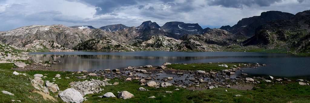
Point 12,540 is a very unknown peak in the heart of the Beartooth Mountains between Castle Rock Mountain and Castle Rock Spire. Most people think that this peak is actually called Castle Rock Spire due to the label on the USGS quad for the area however that is actually the spire just to the east of this peak. Point 12,540 actually has a large flat summit area and due to the fact that it is slightly higher than Castle Rock Spire, this peak is ranked and has a full 440 feet of clean prominence with Castle Mountain being its parent peak. Castle Rock Spire, is unfortunately unranked sitting between Point 12,540 and Castle Mountain. This is one of the Montana 12,000 foot peaks and can arguably be the most difficult one due to the long approach and difficulty of the climbing on its west ridge. The hardest climbing move is at least as difficult as anything encountered on the standard east ridge on Granite Peak.
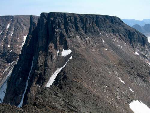
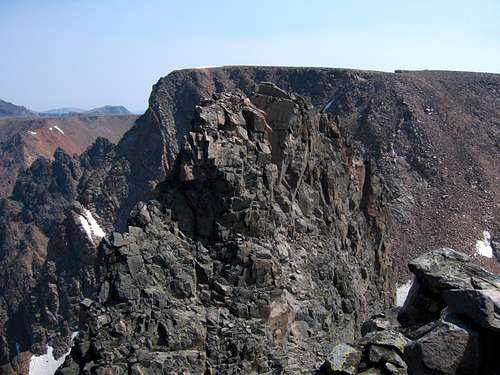
Point 12,540 from the summit of Castle Rock Mountain
Approach 1
There are two main ways to approach this peak, both are long. The way I went starts from US Highway 212 at the southern margin of the range. Likely the best place to start is the Clay Butte trailhead or the Beartooth Lake trailhead. Since the trail heading around the east side of Beartooth Lake is very marshy, the Clay Butte trailhead may be better, however you will have to start your hike with a 600 foot descent going this route so pick your poison. No matter which trailhead you choose, you need to get to Native Lake.Beartooth Lake Trailhead
From the MT 308/US 212 junction at the south end of Red Lodge, Montana head west on US 212 for 40.5 miles going over Beartooth Pass and turn right on the signed turnoff for Beartooth Lake and campground. Take this gravel road and stay straight after 0.3 miles and pass the boat launch. At 0.6 miles from the highway, turn left to the trailhead marked with a sign with room for no more than 10 cars.
Clay Butte Trailhead
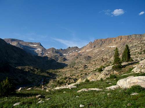
From the Beartooth Lake turnoff, continue west on US Highway 212 for 1.5 miles towards Cooke City and turn right on the gravel Clay Butte Road. Drive this good road for 1.5 miles to the signed trailhead on the roads' left side right before a sharp switchback at 9,580 feet in elevation. If you start at the Clay Butte trailhead, start hiking the nice trail and reach a signed junction with the Granite Lake trail after 1.1 miles at 9,260 feet. Continue on the trail as it weaves up and down small hills and cross many tiny creeks along the west side of Beartooth Butte. After 1.9 miles from the Granite Lake junction where the stream descends a short ways to a larger creek at a little 3 foot waterfall, leave the trail, cross the creek and follow a cutoff boot path for 0.3 mile that meets the main Beartooth High Lakes trail at the southern end of Native Lake.
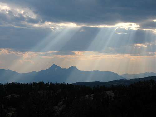
Sunbeams over Pilot Peak from the Clay Butte Trail
If you start at the Beartooth Lake trailhead, walk around the lakes' east and north sides through a large swamp (bring waders) OR above the swamp on many game trails in the trees to the east. Horrible bushwhacking, creek crossings and route-finding is insured if you do this. Take the swamp and deal with it. At 1 mile from the trailhead, the swamp ends and the trail climbs gently through beautiful meadows along the east side of Beartooth Butte for 1.9 miles to the signed junction with the Island Lake trail. Stay straight for another 0.7 miles to the north end of Beartooth Butte and a signed junction with the Clay Butte Trail. Stay right onto the Beartooth High Lakes trail and go 0.5 mile to the south end of Native Lake.
From Native Lake, stay on the trail as it contours around Surprise Lake, then descends 400 feet to a creek crossing and an unnamed lake at 9,320 feet, 2 miles from Native Lake. There is good camping here which is located only a few feet south of the Montana/Wyoming border. Do not follow an obvious trail heading steeply up the hill next to the meadow but instead hike around to the north side of this small lake and catch the main trail just out of view from the meadow. Contour around Thiel Lake and descend slightly to the creek draining Throop Lake at 9,400 feet.
Shortly after this crossing continue up steep switchbacks for 300 feet to a flat meadow at 9,750 feet where the slope eases. This part of the trail has substantial horse damage and is slick. Cross the Marmot Lake outlet stream (good camping and fishing) at 9,860 feet and cross over a small saddle just above Kidney Lake. Hike along the shore of Kidney Lake and make another 300 foot descent to Wright Lake. Great Camping can be found at Wright and Martin Lakes. Leave the trail here and walk north for 0.3 mile around the left (west) side of Martin Lake to its northwest corner. Continue up a small valley from here and climb to a small 10,040 saddle, with fantastic views of the Castle Group, 0.5 mile from the northwest corner of Martin Lake.
From this saddle, descend slightly passing a very small tarn and begin contouring right at 10,000 feet and up a prominent valley to the northeast towards Crystal Lake. Walk around the right (east) side of Crystal Lake on talus and grass to its north side at 9,900 feet with some of the best camping around, 0.8 miles from the small saddle. The approach is over (well...kind of). Continue north around the Pleiades Lakes and contour west around a small knob. Descend to the creek draining Flat Rock Lake and follow it to the lake, 1.2 miles from Crystal Lake. Hike around the right (east) side of Flat Rock Lake for 0.5 mile and continue along the right side of the inlet stream on talus another 0.7 mile to Varve Lake at 10,450 feet. This is where you meet the second approach option coming from the west.
 View of the Castle Group from Flat Rock Lake View of the Castle Group from Flat Rock Lake | 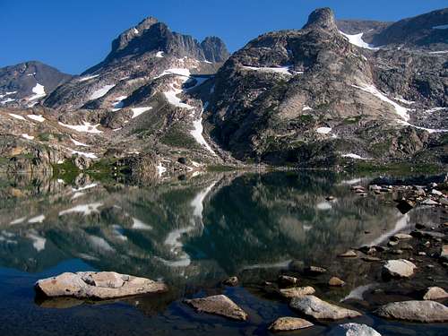 Point 12,540 and Castle Mountain reflecting in Varve Lake Point 12,540 and Castle Mountain reflecting in Varve Lake |
Approach 2
This approach might be easier overall but not quite as scenic. Start at the West Fork Rock Creek Trailhead. This is one of the more popular trailheads in the Beartooth Mountains and offers fantastic scenery. From the center of Red Lodge at the MT 308 and US 212 junction, head west 0.3 miles on US 212 and turn right onto the West Fork Road with signs for the Red Lodge ski area and measure distances from this turnoff. The road immediately comes to a Y, stay left and head up the paved road passing the Palisades Campground Road (gravel) on the right after 1.1 miles. Continue and enter the Custer National Forest after 2.8 miles and turn left to stay on the West Fork Road at 2.9 miles. Taking a right at this turnoff takes you to the ski area. Pass the winter closure gate at 5.2 miles, the Basin Lake Campground at 7.2 miles and the road turns to gravel at 7.4 miles. At mile 10.5, pass the Cascade Campground and reach the trailhead at mile 13 with an elevation of 7,890 feet. Here there is room for about 40 cars and 7 horse trailers and a pit toilet is available.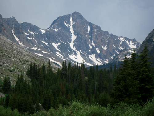 Whitetail Peak from the Quinnebaugh Camp
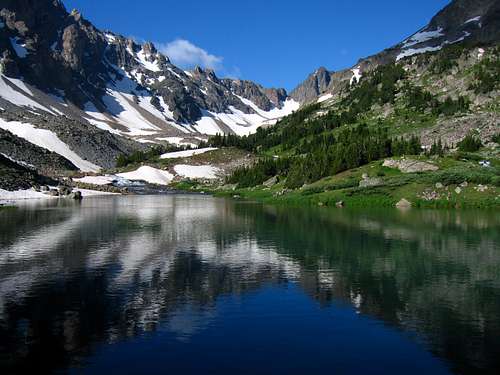 Shadow Lake morning reflection
Route - West Ridge, Class 4
 Navajo Tarn Navajo Tarn | 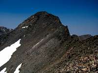 Castle Rock Mountain Castle Rock Mountain |  Point 12,540 from saddle Point 12,540 from saddle |
From the saddle, turn right and beging climbing talus on the crest for 0.15 mile to 12,250 feet where the fun begins. You are looking at the steep west ridge of the mountain. It isn't as hard to climb at it looks but be prepared for some exposed scrambling. Climb up a deep gully in the face to the right of the crest until you get to a very steep 20 foot chimney. Either climb up te chimney (low Class 5) or the face just to the right of the chimney (Class 4) on small ledges. At the top of this first chimney, continue up the same deep gully which is very loose in places. Reach the base of a second, 30 foot chimney and locate a ledge on the left and climb north on this ledge (Class 3). This ledge is the key to the route. It's about 4 feet wide but slightly sloping downhill so extreme care should be taken. A fall here puts you 50 feet or more down the gully. This ledge continues north back to the ridge crest where you'd think ends at the multi-thousand foot vertical cliffs of the north face however a short 25 foot talus slope appears at the last minute allowing for an easy walk to the summit plateau. A cairn marks the top of this small slope, be sure you remember where it is. Walk easily east for 0.1 mile to the high point and admire the views of Castle Rock Spire. You are only 40 feet above it. Descend the way you came. It makes sense to include a traverse to Castle Rock Mountain if you spend the energy to get all the way up here.
RT Distance:
From Navajo Tarn - 4.4 miles
From Crystal Lake - 11.2 miles
From Beartooth Lake Trailhead - 35.2 miles
RT Elevation Gain:
From Navajo Tarn - 1,900 feet
From Crystal Lake - 2,600 feet
Map
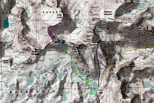
RED: Approach 1; Crystal Lake/Varve Lake from the south
ORANGE: Approach 2; West Fork Rock Creek/Omega Pass/Varve Lake from the west
PURPLE: Castle Mountain South Slopes Route (Class 2)
LIGHT GREEN: Route to the saddle between Castle Rock Mountain and Point 12,540 (Class 2)
DARK BLUE: Point 12,540 West Ridge Route (Class 4)
LIGHT BLUE: Castle Mountain East Ridge Route (Class 2)
PINK: Traverse from Castle Rock Mountain to Point 12,090 (Class 3)
GREY: Traverse from Castle Rock Mountain to Darlene Mountain (Class 2)
Summit Views
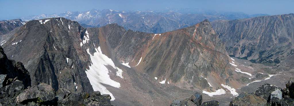
Castle Rock Spire and Castle Mountain from Point 12,540
Camping/Red Tape
There is great camping at the north end of Crystal Lake and Shadow Lake as well as many places along the Beartooth High Lakes trail. Camping is also available at all the trailheads. This area is within the Abasorka-Beartooth Wilderness therefore no motorized travel, including but not limited to, cars, motorcycles, bicycles, hang gliders, airplanes, scooters, etc... is allowed.Please practice leave no trace practices and do not disturb wildlife. You are in grizzly bear country here so always carry bear spray, or a gun, or both for protection only if you are attacked. Report any bears you may have killed or injured to a ranger as a result of any defenses you may have taken.
There is a ranger office right at the junction of US Highway 212 and the West Fork Road at the southern end of Red Lodge.