
-
 24068 Hits
-
 83.55% Score
-
 17 Votes
|
|
Mountain/Rock |
|---|---|
|
|
39.69560°N / 105.9032°W |
|
|
12477 ft / 3803 m |
|
|
Overview

Mount Trelease appears to be a pyramid from I-70 in the Loveland Pass area just west of Denver. The summit is a banal, fairly flat area though with exceptional views of Hagar Mountain and The Citadel. Trelease sits between Dry Gulch and I-70 and would probably not be your first choice of summits in this area but it makes a great start to a loop including the aforementioned 13ers. It is also a worthy ski mountaineering destination as it sits adjacent to the Loveland Pass Ski Area.
The base of Trelease is at about 10,600 feet so it's only about an 1800 foot climb. There is a trail of sorts on it's eastern side that appears to be the remnants of an old road. There are ruins of a cabin just off the road where it fades out near a pond. The route is Class 2 at best and really is just a steep hike with altitude.
Mount Trelease was also the site of an airplane crash in 1970 involving the Wichita State football team. Their plane went down when the captain tried to fly low and show them the area. When he realized he would not be able to get over the Continental Divide, he banked around but struck Mt. Trelease.
Mount Trelease is named after William Trelease, a botanist from the late 1800's.
 |  |  |  |  |
Getting There
From Denver, take I-70 west to Exit 216 (Loveland Pass). When you get onto the off ramp, take the first dirt road to your right. It's just before the ramp turns into a road that goes back under the interstate. Follow this road a short distance to a gate and park there. This is also the approach to the Dry Creek route on Hagar Mountain and The Citadel.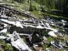 |
Red Tape
No permits or fees required.When To Climb
mid-June through September/early October. Consider an axe for the edges of, or out of, this season.Camping
Camping areas can be found in Dry Gulch in nice alpine settings. There are also lots of areas near the summit which would be nice to camp but little protection from wind. There is a foundation of a two-room cabin at about 11,600 feet just to the north of the "road"/trail near a small pond that would suffice as a flat spot to camp. In reality, this area probably doesn't get too much camping due to its proximity to Denver. If you wanted to sleep in your car to acclimate, I would suggest not doing it at the trailhead. It's just mere yards from I-70 and the noise would drive you nuts. If you are attempting this out of ski season, (as I did), I would suggest driving over Loveland Pass into the Arapaho Basin ski area. Turn right into an area signed "Last Chance Parking" and sleep in this parking lot.Mountain Conditions
Forest Service Regional Office740 Simms
Lakewood, CO
(303) 275-5350
avalanche recording (303) 275-5364
Arapaho National Forest
(303) 275-5610
Colorado State Road Patrol Conditions
(303) 639-1111
(this material shamelessly taken from Aaron Johnson's Hagar Mountain page)