
-
 31528 Hits
-
 89.01% Score
-
 28 Votes
|
|
Mountain/Rock |
|---|---|
|
|
38.67940°N / 106.6111°W |
|
|
12985 ft / 3958 m |
|
|
Fossil Ridge Wilderness Overview
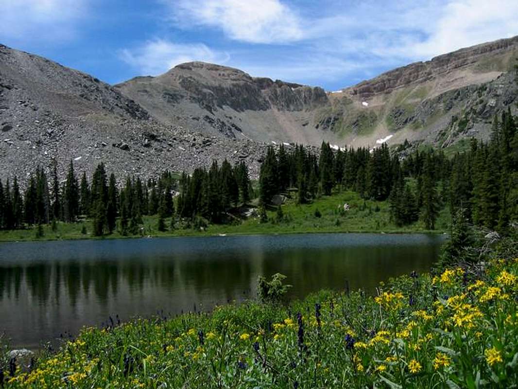
Fossil Mountain above senecio and monkshood from Lamphier Lake. Fossil Ridge Wilderness.
 The Fossil Ridge Wilderness is located 16 miles northeast of the city of Gunnison, CO. Designated wilderness in 1993 it represents an extreme south eastern spur of the grand Sawatch Range. Geographically and geologically it offers a distinct variation on the Sawatch's general theme. The Fossil Ridge nomenclature refers to the high ridge of Paleozoic aged sedimentary rock of the region that lies atop the more widespread igneous and metamorphic basement rock that comprises so many of Colorado's mountains. This ancient stack of sedimentary rock gives the Fossil Ridge Wilderness a unique flavor. Although the wilderness area is only 32,000 acres it feels quite remote due to its position and the adjacent insulator of the Fossil Ridge Recreation Manegement Area (one caveat though, this adjacent recreation manegment area is open to motorized travel...).
The geologic history of the Fossil Ridge Wilderness begins 1.2 billion (Pre-Cambrian Period) years ago with the establishment of the granites, gniesses, and schists that make up the underlying basement rock that comprises much of the Colorado Rocky Mountains. On top of that unimaginably deep history lies a nonconformity where either the deposition of rocks didn't record history, or, more likely, subsequent erosion erased it. 300 million years ago (Late Pennsylvanian Period) more recent history picks up in the geologic record. Colorado at the time consisted of two mountainous island chains rising from a shallow sea (a volcanic archepelago). The marine basins fostered ancient life forms and an ideal depositional environment. The history recorded by these rocks tells of marine limestone that developed as ages and ages of dead diatoms and other simple organisms settled to the sea floor, draping it in a thick blanket of calcium carbonate (Minturn Formation, Leadville Limestone member). Over time the coarser quartz sediments eroded from the nearby mountains covered some of these limestones with deposits, often skirts, of distinctively banded paleozoic sandstones, mudstones, and siltstones. These distinctive red deposits are now famous as the Maroon Formation, the rock of Colorado's glorious Elk Range.
The most enlightening aspect of the Fossil Ridge Wilderness is that, in the vicinity of Lamphier Lake the dance of these ancient geologic bodies, between uplift and erosion, deposition and weathering, continuation and oblivion, exists in plain sight. From Lamphier Lake, as seen in the photo below, the marine limestones form the grey cliffs above the trees, above that the red sandstones of the Maroon Formation form a very small, shrinking cap, above the grassy plateau on Squaretop Mountain's summit. To the left the sandstone deposits tilt downward... this is the uplift of the Laramide Orogeny illustrated in grand form. The main anticline of the Sawatch Range pushed these previously horizontal deposits upward as the rock layers pushed up off to the east. This mantle of sedimentary rock used to be found across Colorado's Rockies but erosion, glaciation, weathering, and time have stripped so much of it away. An isolated island of history like the Fossil Ridge Wilderness gives a remarkable perspective on the mountains. It literaly is comprised of seafloor hoisted to nearly 13,000 feet!
If you like Colorado geology you will like the Fossil Ridge Wilderness.
For more information on Colorado's spectacular geologic history please visit Jeremy McCreary's comprehensive webpage.
Square Top Mountain Overview
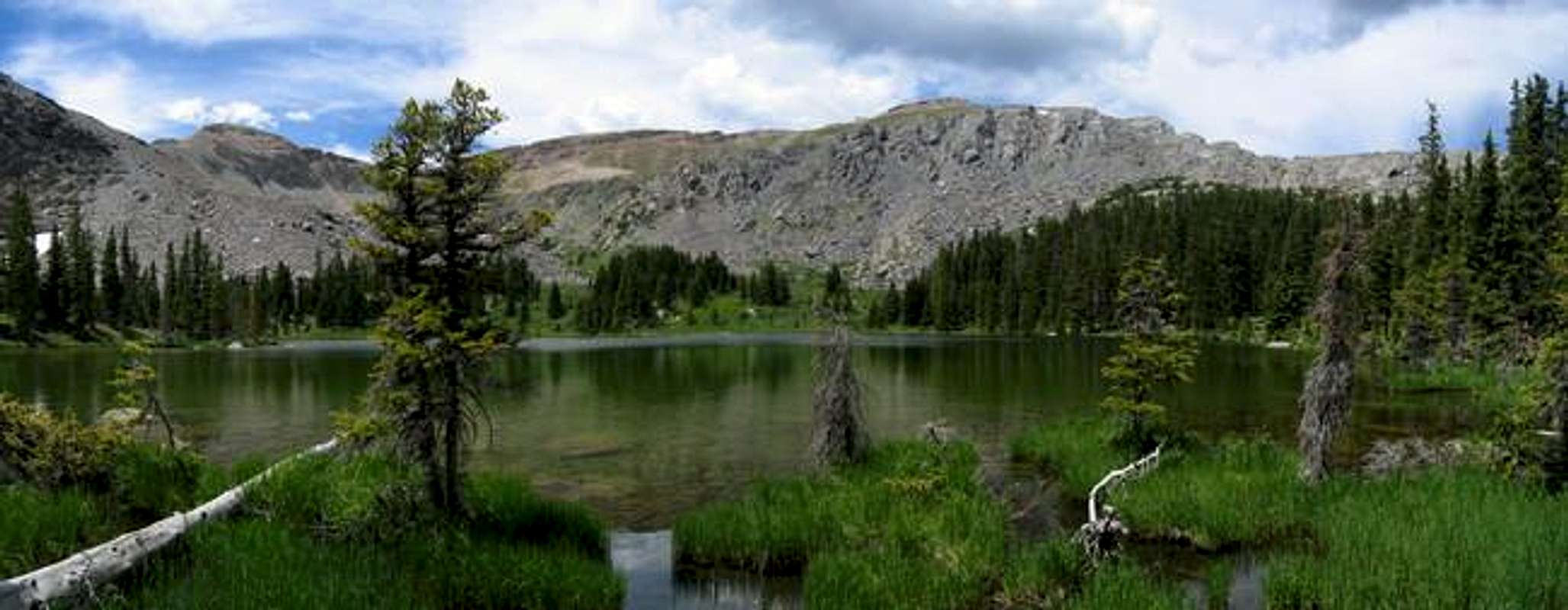
Square Top Mountain's slanting sedimentary layers above its limestone cliffs, seen from Lamphier Lake. Fossil Mountain is on the left.
An oddly shaped summit, Square Top Mountain is the headpiece of the view from lovely Lamphier Lake. However it is the lower of the two Square Top Mountains found in Colorado and it likely is most often only climbed enroute to its higher companion, Henry Mountain. However these two minor detractions shouldn't distract a climber from a unique summit... The Fossil Ridge Square Top is more interesting then either its like named summit in Clear Creek County or its nearby companion.
Square Top Mountain is a summit comprised of a short block of rotten red sandstone, on top of shiny grey limestone cliffs, rising above a thick skirt of discarded boulders... It is a tilted geologic layer cake. The name Square Top likely refers to the block of red sandstone...although it apears a bit tilted to be termed square in the authors eye. In any case the mountain is atypical. It it not a classic arete or cone. It is different.
The limestone, that predominates in the lower portions of Square Top Mountain, is much the draw, the prescribed route on Square Top goes from Gunsight Pass (imaginatively termed "not recommended for horses" on the National Geographic Trail Illustrated Topographic Map) west along Square Top's east ridge. This ridge is a strange limestone dreamland of easy scrambling. The northside of the ridge is not recommended. The ridge crest and south side offer multiple routefinding choices on some nice rock brocken by ledges... with only the occasional tipsy boulder thrown in. Above these limestone cliffs is a grassy plateau, capped by a distinctive island of sandstone. A classic regressive sequence. This mountain bears the gravity of deep time.
Square Top Mountain represents a beautiful area and sports an interesting route; please see the submitted photos for more information.
I personaly enjoyed Square Top Mountain a great deal. It is a fun mountain to ascend and the East Ridge was one of the more interesting routes I have ever done... and the whole experience provided utter and complete solitude and a wonderful sense of the wild.
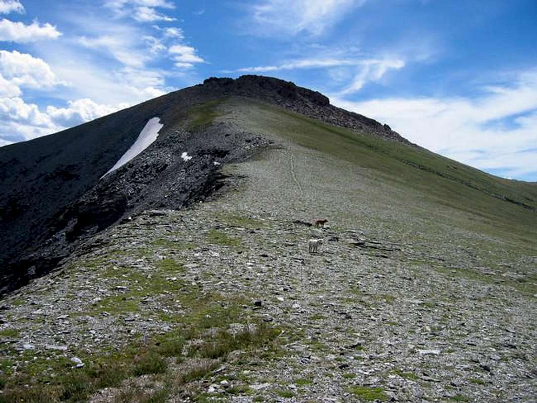
The grassy connecting ridge between Square Top Mountain and Henry Mountain.
Maps and Directions

Routes on Square Top Mountain: In red is the primary Gunsight Pass-East Ridge Route which is 7 miles long roundtrip and traverses a class 3 ridge. The blue route is 1.3 mile (roundtrip) addition of Henry Mountain. In yellow is the easy access grass gulley that bypasses the East Ridge and can be used on either ascent or descent.
Approach: Gold Creek Campground access
To get to the Gold Creek Campground, the primary access point for the southern Fossil Ridge Wilderness, travel 15 miles east from Gunnison or 20 miles west from Monarch Pass on Highway 50 to the tiny townlet of Parlin. At Parlin go north on the strangely idyllic Highway 76 to the even more surreal yet prosperous town of Ohio City. From Ohio City turn north just after passing the Motherload General store onto Forest Service Road 771. This maintained road is passible for passenger cars all the way to the Gold Creek Campground.
Routes: Gunsight Pass-East Ridge Route, 7 miles roundtrip, class 3.
For the Gunsight Pass Route begin at the Gold Creek Campground Trailhead. From the trailhead continue along the road a quarter mile to the trail that breaks off on the left. This junction is marked with a sign pointing the way to Lamphier Lake. The wide trail winds up along Lamphier Creek passing through pine and aspen. After about 3 miles it reaches Upper Lamphier Lake. According to the map the trail then continues to the right of a smaller sub-lake and then continues up towards Gunsight Pass... From the lake onward the author found the trail to be faint and misleading (but it was possible I was on a faint use trail. In any case work your way up hilly terrain towards the lowpoint of the saddle between Square Top Mountain on the left and Broncho Mountain on the right. From the pass the remaining ridge to your left may startle you. It is slabby, broken, and a bit exposed on its north side. Stick to the south side of the ridge and scramble/scamper your way across this bit of class 3 terrain. Little grass ledges on the south side of the ridge make the going suprisingly easy. A few places it is easiest to get on the ridge crest and boulder hop your way along. As the ridge nears the mountain proper you will want to drop to the south into a grass gully above a gnarly talus skirt. This will put you beneath the more impressive grey slabs of limestone on this ridge (these slabs look fun to climb on for those so inclined). Go up the vary narrow grass gully to emerge on the sloping grass covered summit plateau. The final summit cap is visible just to the west. Stroll across the grass to triumphantly climb the sandstone summit block. Return either the way you came or use the Gully Shortcut described below.
Henry Mountain Addition: 1.4 miles roundtrip, class 2.
To add Henry Mountain continue on from the summit of Square Top. 0.7 miles of easy terrain allows one to stand atop the highest mountain of the Fossil Ridge Wilderness.
Gully Shortcut: 0.5 miles long (one way), Class 2.
This shortcut allows for one to bypass the class 3 sections of the East Ridge. Either comming or going locate the grass gully that attains the summit plateau... instead of reaching it via the East Ridge continue along the eastern periphery of the talus skirt that falls away from the gully. This will keep the difficulty down but it isn't always the most pleasent route... it flirts with talus and a bit of scree. However it is the recommended descent if a storm is approaching.
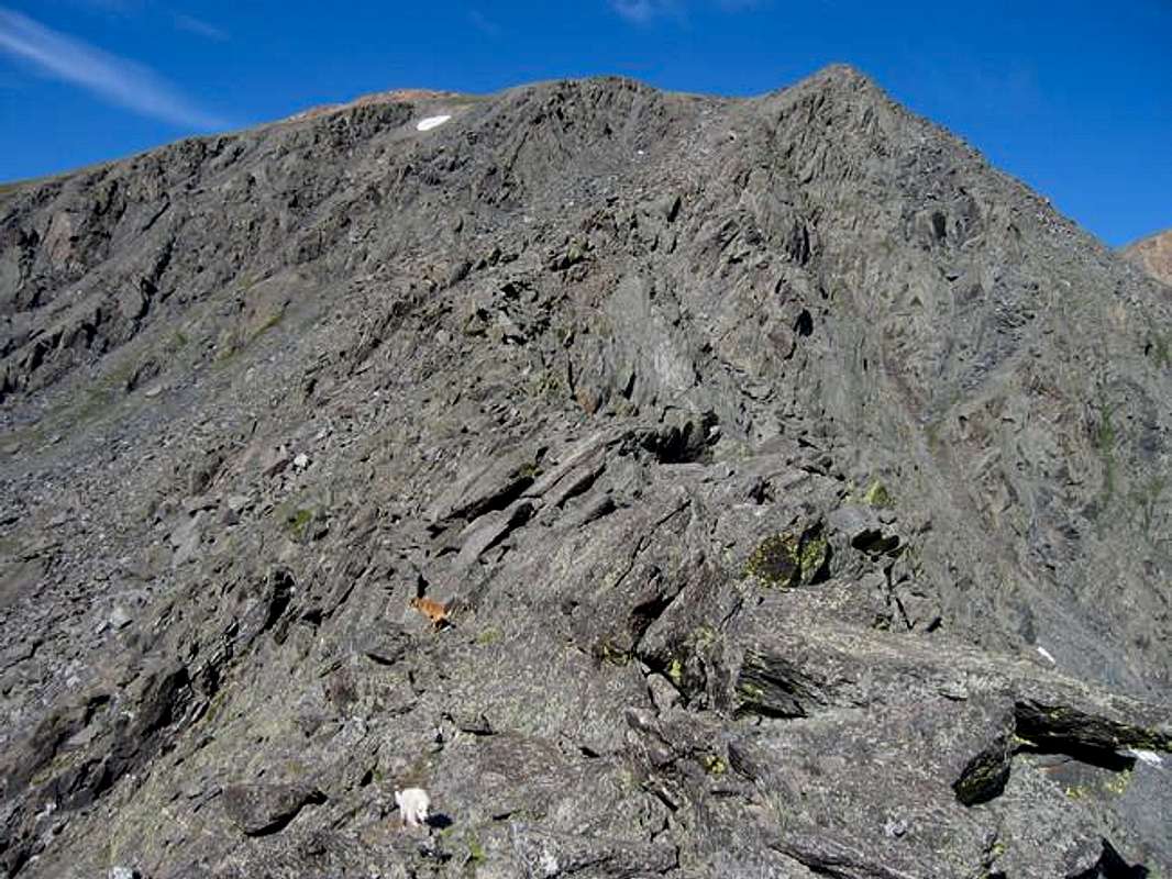
Square Top Mountain's slab studded east ridge offers a unique oportunity to scramble on Colorado limestone.
Red Tape
Wilderness Regulations apply.No mechanized access beyond the wilderness boundary.
Remove everything you bring into the wilderness. Use extreme caution with fire.
Be courteous and respect the wildlands...
For more information contact:
Grand Mesa, Uncompahgre and Gunnison National Forests
2250 Highway 50
Delta, CO 81416
(970) 874-6600
Please note that the Gold Creek Campground is a fee area. Be prepared to pay $8 a night to stay at the established campground.
When To Climb
Due to Square Top Mountain's isolated position it is recommended as a summer climb. Being located to the west of the main body of the Sawatch likely means far more snowfall in the winter compared to summits further east.Camping
Gold Creek Campground is an established forest service campground staffed by a private company (RRM). While this represents an alarming trend $8 buys you a night's stay with a *clean* bathroom. This campground is served on a first come first serve basis.For those opting not for the consumer option a 2.75 mile hike will get you a superb camping spot beside the lovely Upper Lamphier Lake. This would be far and away the preffered place to spend the night.
Mountain Conditions

jfrishmanIII - Jun 20, 2007 1:56 am - Voted 10/10
Fee IncreaseGold Creek Campground will now run you $10.00 a night.
djilk - Jul 27, 2015 6:57 pm - Hasn't voted
Re: Fee IncreaseAs of 2015 the campground is free with volunteer maintenance and "donations accepted." Also there are several dispersed campsites next to the road just prior to the campground.
Jebers - Jul 7, 2013 4:57 pm - Hasn't voted
Wilderness RegulationsAs wilderness regulations apply I was shocked and disturbed to see pics of two dogs running unleashed in this high alpine area, allowing pets to disturb the wild residents is a disconnect from "courteous and respect the wild lands ", and unless I'm wrong a violation of the wilderness regulation.
djilk - Jul 27, 2015 7:16 pm - Hasn't voted
Re: Wilderness RegulationsThe leash rule is true in many wilderness areas but it is not a general wilderness rule - some allow dogs off-leash. Unfortunately the Forest Service does not make it easy to figure out, you probably have to look at the regs on the sign at the trailhead.
djilk - Jul 27, 2015 7:11 pm - Hasn't voted
Actual grassy routeI started to write up a separate route but decided to just put it here. The yellow line on Jon's map does not show the easiest route. The easiest route is actually trail most of the way, as follows: From the north side of Lamphier Lake, circle around counterclockwise to the southwest side (it is a bit marshy). There is a stand of trees on a high point that is a linear knoll. Head southwest on that until leaving the trees, and you will see a use trail heading further southwest, which is toward the low point between Fossil and Square Top. If you have any trouble finding this trail, it runs parallel to the little creek on its northwest side - the grassy side, not the rocky side. This trail continues southwest and then circles north into the grassy basin and up to the ridge, to within about 400 vertical feet of the summit. The summit itself requires at least one class 2+ scramble move, I found it easiest on the north side.