

-
 45375 Hits
-
 90.64% Score
-
 33 Votes
|
|
Mountain/Rock |
|---|---|
|
|
44.10084°N / 114.97643°W |
|
|
Mountaineering |
|
|
10229 ft / 3118 m |
|
|
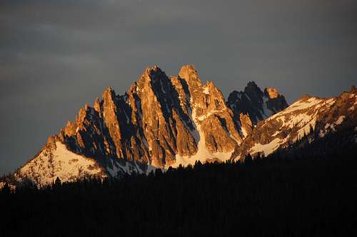
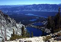
From the south
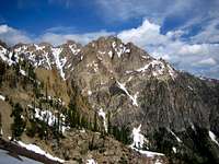
Overview

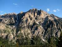
From the NW
Mount Heyburn is the most visible, well known and according to guidebook author Tom Lopez, the most majestic of the peaks in the Sawtooth Range. From the valley, the mountain appears to have three distinct summits. There are an East and a West Summit with a difference in altitude of only one to two feet, the West Summit being the higher. The third high point is the West Pinnacle, which is noticeably lower.
From the east
Climbs on Mount Heyburn can be accomplished in one very long day from Redfish Lake, or more leisurely with a camp near the mountain.
The granite in the Sawtooth Range varies from excellent, hard Yosemite quality rock to rotten, decomposed, virtually unclimbable, crumbling masses of what some authors have called "ball bearing stuff". Most of the West summit is composed of the latter, but it does have several fine routes including the classic Stur Chimney. The rock is reportedly somewhat better on approaches to the East Summit and the West Pinnacle is supposed to have very good rock.
Robert and Merriam Underhill with Dave Williams made the first ascent of Mount Heyburn in 1935 via the Southwest Ridge.
Getting There
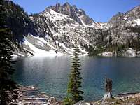
View from a Bench Lake
Mount Heyburn is located in the Sawtooth National Recreation Area, Sawtooth National Forest, in south-central Idaho. The nearest town is Stanley. Access to the mountain starts from Red Fish Lake which is 12 miles easterly from Stanley off Highway 75.
Routes on Mount Heyburn are approached via either the Bench Lake Trail or the Redfish Lake Creek Trail. All of the routes can be accessed via the Bench Lake approach.
The Bench Lake Trail leaves directly from the parking area provided for backpackers at Redfish Lake. It is about 4.5 miles to the first of the Bench Lakes, then about 1.5 miles of rough trail to the highest of the Bench Lakes. From there one travels cross country to the start of the routes.
View down Bench Lakes approach
The Redfish Lake Creek Trail starts at the upper end of Red Fish Lake which can be reached by either a 5 to 6-mile hike around the lake or a short boat ride in season. Details regarding boat service can be obtained through the Redfish Lake Lodge at 208-774-3536.
Red Tape
There are no restrictions on access in the Sawtooth National Recreation Area except for large groups and pack animals in certain parts.
A Northwest Forest Pass is required for parking at the trail heads.
Routes Overview
WEST SUMMIT

Stur Chimney
Stur Chimney ,II, 5.4 This is the classic route on the peak located toward the north end of the west face. It is approached from the saddle between the West Summit and the West Pinnacle which can be reached from either the Bench Lakes or the Red Fish Lake Creek Trail. There are two pitches in a classic chimney with overhanging chock stones. It ends almost directly at the summit.
Louis Stur, Jerry Fuller and Jim Ball made the first ascent on 1 October 1958.
A note on the rating of the Stur Chimney. Tom Lopez rates the route as Grade II, 5.2 in his guidebook. An older guide (by Stur??) rated it Grade II, F5 (F5 is 5.3 to 5.4). The Sawtooth Guides (scroll down to description) rate it 5.7. I personally found it to be on the easy side of mid 5th class, not as easy as 5.2, but certainly not as hard as 5.7, hence my rating of about 5.4.
Air photo showing location of Stur Chimney: Idaho Climbing Guide
Southwest Ridge, II, 5.6 This was the first ascent route. The upper part of the ridge was described by Robert Underhill as a "crumbling mess". Robert & Miriqam Underhill with Dave Williams made the first ascent in 1935.

In the Petzolt Couloir
Petzolt Couloir, II, 5.3 A1, or 5.9 (AKA East Face Snow Couloir) The technical part of the route is a 40 foot vertical wall. Paul Petzolt, with E. Carter, C. Fisher, B. Merrieam, and C. Wilcox made the first ascent in 1947.
Northwest Ridge, II, 5.6 Using a couloir to access the ridge leaves 3 pitches to the summit. First ascent by a group of Iowa Mountaineers in 1948. More direct variations have been climbed, also rated at 5.6.
EAST SUMMIT
South Rib, II, 5.2 Climbs the west and south faces of the peak.
Northeast Ridge II, 4 A pinnacle studded ridge with some route-finding problems.
WEST PINNACLE (10,154 feet)
Tunnel Route, III, aid, (A1?) This is the only reported route on the pinnacle. It ascends the pinnacle's north side which is reached from the saddle between the pinnacle and the west summit.
Camping
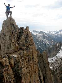
The tiny summit
Camping is allowed with little or no restriction within the Sawtooth National Recreation Area. The best base for Mount Heyburn would be near the Bench Lakes.
Mountain Conditions
Sawtooth National Recreational Area office located in Stanley, Idaho at 208-727-5000.
Sawtooth National Forest
Peak Name
Even though the mountain is named Heyburn Mountain on the USGS Quad, every other source that we have seen refers to it as Mount Heyburn. So, this is the designation that we have chosen to use.