
-
 20298 Hits
-
 87.56% Score
-
 25 Votes
|
|
Mountain/Rock |
|---|---|
|
|
48.51920°N / 120.6166°W |
|
|
8280 ft / 2524 m |
|
|
Overview
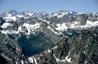
Big Kangaroo is the high point upon Kangaroo Ridge, which is a three-mile long N/S ridge, located E of the Liberty Bell group and SW of the Wine Spires & Silver Star Mountain. Kangaroo Ridge provides an interesting variety of summits and climbing opportunities but unlike it's more famous neighbors to the W and to the NE is visited less often. With Hwy 20 below and visible from many of the summits (on the ridge) the sense of solitude is imperfect but because of the lack of competing climbing parties for routes in the area you can still achieve a sense of adventure and can perhaps experience something akin that which the pioneering climbers, of the area, experienced themselves.
Fred Beckey states (in his "Cascade Alpine Guide - Rainy Pass") that through his diligent search of Forest Service and other records he was unable to find the origins of such colorful names as Kangaroo Ridge, Silver Star and Liberty Bell but that the name was mentioned on Forest Service maps as early as 1926. Eric has mentioned that "Somebody saw this long ridge with fairly evenly-spaced peaks on it and remarked that they were like the hops of a kangaroo." Whatever the origin of the name, it does add some color to this interesting ridge of peaks and peaklets.
Getting There

Follow cairns and paths through the brush, staying W of and above Early Winters Creek, heading S towards Kangaroo Pass (3 miles distant). At about one mile from the car you will see a small clearing by the Creek and you might notice some old wreckage from a small airplane. In approx. 2 miles (from the car) a larger meadow is reached and if you look up and to the NE a prominent gully descends from the ridge-crest just S of the summit. Following this gully to a high Y (taking the left fork) leads you to the start of the climb. Note: This approach avoids some nasty bushwacking late in the season. In early season (as described by Fred on the "Route" page) you can climb directly from the Hairpin turn on Hwy 20 to just N of Big Kangaroo, see West Route.
Red Tape & Recreation Info
Kangaroo Pass (S of Big Kangaroo) is on the N border of the Lake Chelan / Sawtooth Wilderness area. Check with the Okanogon National Forest for rules and regulations pertaining to parking, camping and wilderness travel here: Okanogon National Forest.When To Climb

Camping
Because of the short approach and also the fragile nature of the upper Early Winters Creek meadows and Kangaroo Pass, camping is not recommended in these areas. Forest Service campgrounds are close by and only a short drive East on Hwy 20. Check the recreation link for the Okanogon National Forest (above) for location, availability and fees.If planning on climbs on the E side of Kangaroo Ridge camping and or bivouacing can be done in the upper, barren (almost lunar-like) basin E of Big Kangaroo. This could be combined with a traverse over to Snagtooth Ridge and a climb of Big Snagtooth. The easiest approach to the upper Cedar Creek Basin is to hike in as per the Half Moon N ridge approach and cross over Kangaroo Ridge at a low point on the ridge N of Half Moon and S of Big Kangaroo.
Mountain Conditions
Check wih NOAA, for current weather conditions.Check with NWAC.US here or here (text) for avalanche conditions.
There is a webcam shot of Goat Peak, here, 9 miles to the NE of Big Kangaroo, updated every two hours, provided by Sun Mountain Lodge and MVSTA. Kangaroo Ridge is also a popular XC Ski area in the winter, though the drive is long.
Climbing BETA
