
-
 17581 Hits
-
 87.31% Score
-
 24 Votes
|
|
Mountain/Rock |
|---|---|
|
|
46.62893°N / 12.71939°E |
|
|
Hiking, Trad Climbing, Scrambling, Via Ferrata |
|
|
Spring, Summer, Fall |
|
|
8838 ft / 2694 m |
|
|
Overview
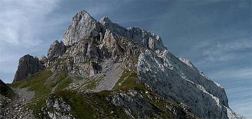 Peralba / Hochweißstein as seen from Passo dell'Oregone Peralba / Hochweißstein as seen from Passo dell'Oregone |
The main ridge of the Carnic Alps is one of the longest consecutive ridgelines of the eastern Alps, measuring almost 100km from Kreuzbergpass / Passo di Monte Croce in the west to Thörl-Maglern in the east. Still, even though a long trekking trail (Karnischer Höhenweg / Traversata Carnica), runs along its crest the area is still rather unknown. Only a couple of summits made it out of their obscurity, mainly the highest summit of the range, Hohe Warte / Coglians and Hochweißstein / Peralba.
 |
 |
 |
The latter is located in a part of the main ridge, in which only few remarkable summits are located anyway, most of them grass summits of moderate elevation. Among these the huge bulk of Hochweißstein / Peralba rises to almost 2700m dominating the whole area. Far from being a beautiful mountain, Hochweißstein / Peralba impresses by it sheer size, a huge, almost cubic block of stone with a large, sloped summit plateau. There is no easy route to the summit, a ferrata and two UIAA I routes are the least difficult ones. Still, on a fine day you will always find a crowd of people up there, thanks to two mountain huts, which are located in the direct vicinity of the mountain. In the north, still on Austrian ground there is Hochweißsteinhütte, in the south-east you will find Rifugio Calvi. From either of the huts the ascent of Hochweißstein / Peralba can be completed in little more than 2h.
The area around Hochweißstein / Peralba was heavily contested during WW I when Austrian and Italian troops fought over the possession of the Carnic Alps main ridge. The mountain, with its domination over the surrounding area and its big summit plateau on which fortifications could be easily constructed, was one of the main targets. The other was the possession of the upper Piave Valley, which in a bend leads behind the south slopes of the main ridge and thus granted easy access for the Italian troops. Thus, Hochweißstein / Peralba as well as the Monte Lastroni - Cresta Righile / Cresta del Ferro Ridgeline on the other side of the valley were heavily fortified. Even today you will find lots of remnants of the war 90 years ago: caves, positions, even an old fort.
 |
 |
 |
Today, Hochweißstein / Peralba is completely located on Italian ground. The main ridgeline - and thus the Austrian - Italian border - runs along several hundred metres to the north. It is also most easily reached from the Italian side, as an old WW I supply road remains being maintained and leads to the Sorgenti del Piave (the sources of the river Piave) which are located directly underneath the giant south face of the mountain. From there a dirt road leads to Rifugio Calvi. At all times climbing routes were being established on the faces of the mountain and the following section gives an overview over the classic ones.
Route Overview
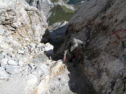 Schwarze Rinne, the crux of the normal route
There are a lot of routes onto Peralba. Here is a overview of the classic ones. You can find more details in the (German) book by P.Holl, Karnischer Hauptkamm, Rother Verlag, ISBN: 3-7633-1254-4.
- Normal Route (north-east) I
Duration: 3h from Hochweißsteinhaus, 2 1/2h from Rif Calvi - East Face IV
First Climbed: date unknown (de Infanti, Pachner)
Length: 200m - East Face / "New Route" IV
First climbed: 1975 (Corrado, Cekada)
Length: 150m - East-South-East Face III
First Climbed: 1963 (Dalla Porta Xidias, Slama)
Length: 170m - South-East Face Chimney III+
First Climbed: 1919 (Samassa, Romanin)
Length: 150m - South-East Face "Via Pietro Sartor" Ferrata
Duration: 1 - 1 1/2 h - South-East Face, left route V-
First Climbed: 1933 (Pachner)
Length: 150m - South-Eastern Pillar V+, A2
First Climbed: 1973 (de Infanti, de Infanti, de Infanti, Morassi, Prodorutti)
Length: 350m - Torre dei Fiori, South-East Face IV-
First Climbed: 1972 (de Infanti, Bizarro, Gonano, dalla Maria)
Length: 300m - South Pillar V+
First Climbed: 1934 (Pachner, Pachner)
Length: 550m - South Face V
First Climbed: 1947 (Stabile, Floreanini)
Length: 550m - Torre Peralba, East Face V+
First Climbed: 1978 (Rainis, Querini)
Length: 300m - Torre Peralba, South Face V+, A2
First Climbed: 1970 (Ursella, Negro, de Infanti)
Length: 280m - Torre Peralba, South Pillar V+
First Climbed: 1983 (Mazzilis et al.) - Torre Peralba, South Chimneys V+
First Climbed: 1981 (Mazzilis, Cargnelutti)
Length: 300m - South-West Face VI
First Climbed: 1982 (Mazzilis, Simonetti)
Length: 340m - Torre SAF, East Face V
First Climbed: 1982 (Mazzilis, Moro)
Length: 235m - Torre SAF, South Face VI, A2
First Climbed: 1971 (de Infanti, Rupil)
Length: 450m - Torre SAF, South-West Face and South Pillar V
First Climbed: date unknown (Mazzilis, Mainardis)
Length: 450m - Torre SAF, South-West Pillar IV+
First Climbed: 1978 (Barbarossa, Cergol)
Length: 300m - Torre Gennaro, South Face VI, A3
First Climbed: 1971 (de Infanti, Grasinich)
Length: 450m - Torre Genaro, South-West Pillar IV
First Climbed: 1979 (Linussio, Mazzilis)
Length: 360m) - Torre Gennaro, South-West Face IV+
First Climbed: 1976 (Piller, Piller, de Podesta, Kratter) - Torre Gennaro, North Face IV-
First Climbed: 1978 (Dabernig, Wiegele, Kaiser)
Length: 200m - South-West Gully II
First Climbed: 1925 (Pittoni, Oberthaler)
Length: 700m - Torre Ravascletto, South Face VI
First Climbed: 1970 (de Infanti, della Pietra)
Length: 300m - South Face of the Western Ridge IV
First Climbed: 1973 (de Infanti, de Grignis, dalla Marta, di Ronco)
Length: 200m - Torre Ursella, South-West Face VI-
First Climbed: 1970 (de Infanti, Negro)
Length: 300m - Torre Tolmezzo, South Face VI
First Climbed: 1972 (de Infanti, de Infanti)
Length: 400m - West Ridge I
First touristic climb: 1907 (Patera, Stabentheiner)
Length: 800m - North-West Face of the West Ridge VI
First Climbed: 1982 (Mazzilis, Moro)
Length: 250m - North-West Face of the West Ridge´, Mazzilis - Kratter Route V+
First Climbed: 1982 (Mazzilis, Kratter)
Length: 400m - North-West Pillar VI-
First Climbed: 1984 (Ortner, Stemberger)
Length: 500m - Western North Face V-
First Climbed: 1978 (Stemberger, Suppersberger)
Length: 500m - North Face, "Carmen" VI
First Climbed: 1985 (Ortner, Ponholzer)
Length: 800m - North Face Pillar, "Nabucco ka Tatschi" VI
First Climbed: 1985 (Ortner, Ponholzer)
Length: 800m - Direct North Face V+
First Climbed: (Ortner, Leitner)
Length: 700m - North Face, Streitmann Route V+
First Climbed: 1934 (Noe, Streitmann)
Length: 700m - North Face, Hans-Oberluggauer-Memorial-Route V+
First Climbed: 1984 (Riegler, Ortner)
Length: 700m - North Pillar IV+
First Climbed: 1976 (Holl, Kriedl)
Length: 600m
Getting There
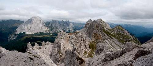 Peralba seen across Cresta Righile
- Northern Trailhead at Ingridhütte
Ingridhütte in Frohntal can be reached from St. Lorenzen in Lesachtal Valley. The side road is well kept only at for the first 5km. The remainder is pretty tough on any car. Lucky are those who drive a 4WD car. St. Lorenzen can be reached as follows:- From the West (Brenner Motorway A22)
Leave the Brenner Motorway near Brixen / Bressanone and follow SS49 to the east through Pustertal / Val Pusteria. To the east of Innichen / San Candido you cross the Austrian-Italian border and follow the road (now B100) to Tassenbach. Turn right (south-east) here onto B111, which you follow to St. Lorenzen. There turn south into Frohntal. - From the North
There are two possible roads:- From Kitzbühel over B108 through the Felbertauern Tunnel to Lienz, then southeast to Oberdrauburg and Kötschach-Mauthen (B110), where you turn on to B111 west into Lesachtal.
- From Salzburg along motorway A10 to Spittal. Turn west on B100 to Oberdrauburg, there south to Kötschach-Mauthen were you turn east on B111.
- From the West (Brenner Motorway A22)
- Southern trailhead near Sappada
- By car:
From Veneto take the Venice-Belluno highway and then go towards Pieve di Cadore.
From Friuli leave the Udine-Tarvisio highway at the Carnia Exit and drive towards Villa Santina and Forni Avoltri (45 km). - By train:
Stop at Calalzo, the end of the line from Venice and Padova.
Go to Carnia on the Udine Tarvisio line. Both train stations are about 40 kilometers from Sappada, to which they connect by frequent bus lines that meet the main trains. - By plane:
The closest airports are the international airports in Venice (180 km) and Trieste (140 km).
From Cima Sappada (a small village near Sappada, not distant from Austria) go by car or on foot along a path that follows river Piave to the sources of the river (30 minutes by car, 3 hours walking). - By car:
Red Tape
As stated with all other summits on the Carnic Alps Main Ridge Hochweißstein / Peralba is located close to the Austrian - Italian border. Even though you won't need it - bring your ID.
Accomodation
There are campgrounds near the villages in the Lesachtal and Piave Valleys. For overnight stays near the mountain use the Huts (Hochweisssteinhaus and Rifugio Calvi). You can find all mountain huts and refuges in the area on the corresponding section on the Carnic Alps Page.
For hotel rooms or apartments, look at the following links:
Austria
Italy
Weather Conditions
The Carnic Alps Main Ridge serves as a weather divide between the Austrian north and the Italian south. The weather can change rapidly so that definite predictions are difficult. Look for information from both sides of the border. Head out early since the weather tends to change around noon.
Maps and Books
Maps
- Lienzer Dolomiten / Lesachtal
1:50000
Kompass Map WK47
Kompass Verlag
ISBN: 3-85491-053-3 - Gailtaler Alpen / Karnische Alpen / Oberdrautal
1:50000
Kompass Map WK60
Kompass Verlag
ISBN: 3-85491-067-3 - Tabacco Maps, all 1:25000
001 - SAPPADA-S.STEFANO-FORNI AVOLTRI
009 - ALPI CARNICHE / CARNIA CENTRALE
Books
German Books
- Hiking and Trecking
- Osttirol Süd
W. Mair
Rother Verlag
ISBN: 3-7633-4132-3
Good descriptions with maps covering: Defregger Berge, Villgrater Berge,
Carnic Alps, Lienz Dolomites - Kärnten
G. Lehofer
Rother Verlag
ISBN: 3-7633-4187-0
Good descriptions with maps covering: Carnic Alps, Gailtal Alps,
Karawanke, Julian Alps (parts) - Gailtal – Lesachtal – Karnischer Höhenweg
Kompass Wanderbuch 982
Kompass Verlag
ISBN: 3-85491-500-4
Good Descriptions with maps and elevation profiles covering: Carnic
Alps, Southern Lienz Dolomites, Gailtal Alps
- Osttirol Süd
- Climbing
- Karnischer Hauptkamm
Alpenvereinsführer
P. Holl
Rother Verlag
ISBN: 3-7633-1254-4
Excellent overall Climbing Guide through the Carnic Alps Main Ridge.
- Karnischer Hauptkamm
Italian Books
- ALPI CARNICHE E DOLOMITI FRIULANE
ISBN: 88-86928-37-8
Euro 16,53
to buy it - ALPI CARNICHE, vol. I - II
A. De Rovere, M. Di Gallo;
Guida dei monti d'Italia CAI-TCI; 1988