
-
 58712 Hits
-
 92.04% Score
-
 37 Votes
|
|
Mountain/Rock |
|---|---|
|
|
40.44530°N / 121.5589°W |
|
|
9235 ft / 2815 m |
|
|
Overview
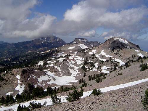
Brokeoff Mountain looms beyond Mt. Diller and Eagle Peak
Brokeoff Mt is the second highest point in the Lassen Volcanic National Park. It sees year-round activity because of it’s easy access from Highway 89. The round trip from the trailhead (approximately 6,600’) to the summit (9,235’) is 7 miles on the summer trail, and about 6 miles during the winter with a direct snow approach. The southern slopes offer excellent ski and snowboard descents all the way to the car on moderately steep pitches. Views from the summit are of Mt Shasta to the north and Mt Lassen to the northeast.
Brokeoff Mt is the furthest west mountain in the park and is adjacent to the parks Southwest entrance. It is three miles southwest of Lassen, and connected to it via a ridgeline. This ridge linking Brokeoff and Lassen includes Mt Diller, Pilot Pinnacle, Ski Heil Peak and Eagle Peak. It is possible to make a ridgeline traverse linking Brokeoff to Lassen. This traverse would involve a few technical sections.
Brokeoff Mt is one of the last remaining remnants of a large volcano called Mt Tehama that was at it’s maximum height and girth around 300,000 years ago. Mt Tehama was a stratovolcano that was about 11,000’ and similar in size and shape to Oregon’s Mt Hood. Because of it’s existence during the Ice Age, Mt Tehama was heavily carved away by massive glaciers which left only fragments from Brokeoff Mt to Mt Conard to the east and Mt Diller to the north. The glaciers left Brokeoff with an impressive vertical north face with an appearance that half of the mountain ‘broke off’.
 |
 |
 |
 |
 |
Getting There
From I-5, take the northern most of two exits for Red Bluff and head east. Red Bluff is about 30 miles south of Redding. After about a mile, toward the edge of town, turn left/east on to Highway 36 and the sign for Lassen National Park. In about 40 miles you will reach the town of Mineral. 5 miles past Mineral turn left/north onto Highway 89 into Lassen National Park. Proceed for about 4 1/5 miles and look for the ‘Post 2 Brokeoff Mt’ sign on the left side of the road. It is just after entering the park boundary and just before the Southeast entrance station. The entrance station is about 5 miles from the intersection of Highways 36 and 89. Parking at Post 2 for the Brokeoff trail is within park boundaries, so a parking pass is required. Use a National Parks Pass to obtain the parking pass or purchase a seven-day pass for $10.
Due to snow during the winter, Highway 89 is closed just past the Southwest entrance station at the ski Chalet.
Red Tape
A backcountry permit is required year round for all overnight trips. Permits can be obtained from the Southeast entrance station, the Loomis Museum located at the Northwest entrance station, from the parks office in Mineral, or from the Almanor Ranger District in Chester.
A parking permit is required to park within park boundaries.
When To Climb
The trail should be clear of snow for hiking from late June through October. For Winter ski touring, December through April are the best months to climb Brokeoff.
 |
 |
Camping
There are 33 campgrounds in or around the Lassen National Park for a total of over 1000 camp sigts. 8 of these campgrounds are within Lassen National Park and are on a ‘first come, first serve’ basis. Each of these campgrounds have fees and do not offer reservations. The closest campground to the Brokeoff trailhead is Southwest, located just inside the Southwest entrance station.
Backcountry camping is allowed by permit only.
Lodging can be found at one location within the park and at a number of locations in Chester.
Mountain Conditions
For weather in the Lassen Volcanic Park click here or check the National Weather Service.
For information on road conditions check Caltrans.
For information on snow pack check here.
For information on avalanche conditions check here.
For more information on Lassen Volcanic Park click here, here or here.
 |
Bob Burd - Dec 3, 2002 10:37 am - Voted 10/10
Untitled CommentIt's worthwhile to note that Brokeoff Mtn is the highpoint of Tehama County for those interested in county highpoints. The county line runs between Brokeoff and Lassen.
keema - Jul 27, 2004 9:56 pm - Voted 10/10
Untitled CommentLassen Volcanic National Park now takes reservations for some campsites. Loop A at Manzanita Lake, Lost Creek Campground, and loop B (North Summit Lake) and C and D (South Summit Lake). Loop E at South Summit Lake is tents only. Reservations can be made by calling 877-444-6777.
hgrapid - Sep 27, 2009 2:59 pm - Hasn't voted
Trailhead is 6635You say the trailhead is at 6800 feet, but this is incorrect. Both the trailhead sign and Google Earth indicate that the trailhead is just about 6600 feet. When I researched it, it appears it is about 6635 feet, making the hike an even 2600 feet to the summit.
Bubba Suess - Sep 30, 2009 3:07 am - Voted 10/10
Re: Trailhead is 6635Noted and corrected. Thanks!
hgrapid - Sep 30, 2009 11:19 am - Hasn't voted
No problemWe hiked it on Saturday. It is clearly marked everywhere, including in the visitors center that the hike is 7 miles round trip and 2600 feet up (6635 to 9235). This hike is pretty steep, but the well maintained trail makes it an easy hike. It is quite beautiful on top.