
|
|
Mountain/Rock |
|---|---|
|
|
44.60890°N / 6.79900°E |
|
|
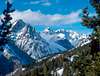
11112 ft / 3387 m |
|
|
Overview
Font Sancte is the highest mountain of Queyras massif . It belongs to Ubaye massif too.Main route:
For very good hikers or mountainers, long ascend. 2 and 3 level.
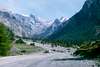
Start point, Haute rua d'Escreins 1784 m.
Use a large path at the right side of Rif Bel (small river) After the valley is becomming less large (2050m), use the path at the left side of the river and continue in the small valley. (3h ascend on path).
Mid point, Basis of a couloir, 2850 m The couloir is full of not stable rocks. That's why it's better to climb this early in the season when some snow is in the couloir ( 35° - 40° ).
To summit Fon Sancte 3387m : Navigate on rocks, 2h30 needed to climb couloir and to go to summit.
Total time for ascend: 5h30 for 1603 Hm. Its recommended to start very early to avoid hot snow (if there is snow in the couloir).
Return on the same route.
It's possible to do a very nice 3 or 4 days hiking tour arround the mountain.
 |  |  |  |  |
Getting There
Guillestre >> 7 km on Col de Vars road D902 >> Val d'Escreins road to Haute rua d'Escreins 1784 m (old village)IGN map: 1/25000e n°245
by car or by train and bus
 |  |
Red Tape
no red tapeWhen To Climb
June - July (it's better to have snow in the couloir than rocks)Camping
huts and lodging listcamping list
Claude Mauguier - May 23, 2005 3:41 am - Hasn't voted
Untitled CommentLambert geodesic system :
lat : 4941,4 / long : 953,8
UTM system, sector 32 (approx. measured on the map...) :
lat : 1966.2 / long : 954.0
Claude Mauguier - May 23, 2005 3:54 am - Hasn't voted
Untitled CommentThe Val d'Escreins territory, where the remainings of the old villages may be seen, has been transferred, as a private territory, to the University of Marseille, now in charge of its preservation, and using this portion of land as an extensive research site as well.
You MAY NOT camp anywhere, nor light any fire. Camping places are strictly designed. During summer climbs, mind about water...!!!! The volume of moraine and various rock deposits makes running water sometimes tricky to find. So always take with you a sufficient water supply (at least 2 l.).
Thus saying for those who would prefer the usual stone bombing of the "nice" season....Scramble there before mid july, always use a helmet, take a very early start, and a quick rythm to get to the top. Or prefer the northern snow covered gullies (from lac Ste Anne area), but the same : cold, bright weather, and a hurry-up climb.