-
 6733 Hits
-
 87.99% Score
-
 26 Votes
|
|
Mountain/Rock |
|---|---|
|
|
44.56902°N / 6.85653°E |
|
|
Hiking, Trad Climbing, Sport Climbing |
|
|
Summer |
|
|
9373 ft / 2857 m |
|
|
Overview
Aiguille Large de Mary 2857 m
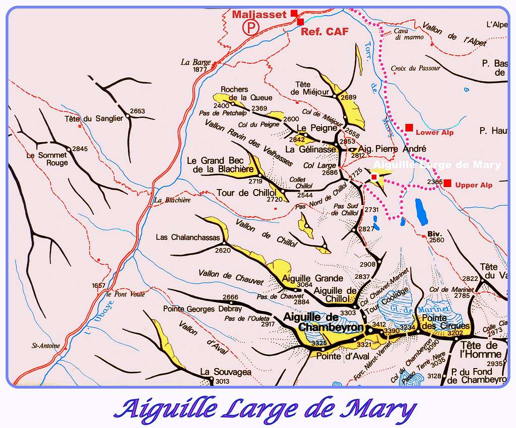
The Ubaye area (Alpes de Haute Provence) really offers an interesting climbing ground, from the limestone towers located near Barcelonnette, as Chapeau de Gendarme and Pain de Sucre, to the peaks of quartzite belonging to the Chambeyron Group and lying nearby the nice hamlet of Maljasset. Aiguille Large de Mary is one of these latter, a beautiful reddish peak overlooking situated on the left hand side of the well known Aiguille Pierre Andrè.

Both the peaks overlook from the right side the upper part of Vallon de Mary, the whose head it's located the Col de Mary 2641 m. This latter is a col located on the boundary ridge between France and Italy and connecting the Vallon de Mary with the Maira Valley. The mountain main interests are both climbing and hiking. In fact the trail along the Normal route to the summit is a pleasant hike, allowing to take some magnificent views over Marinet Lakes and Aiguille de Chambeyron.
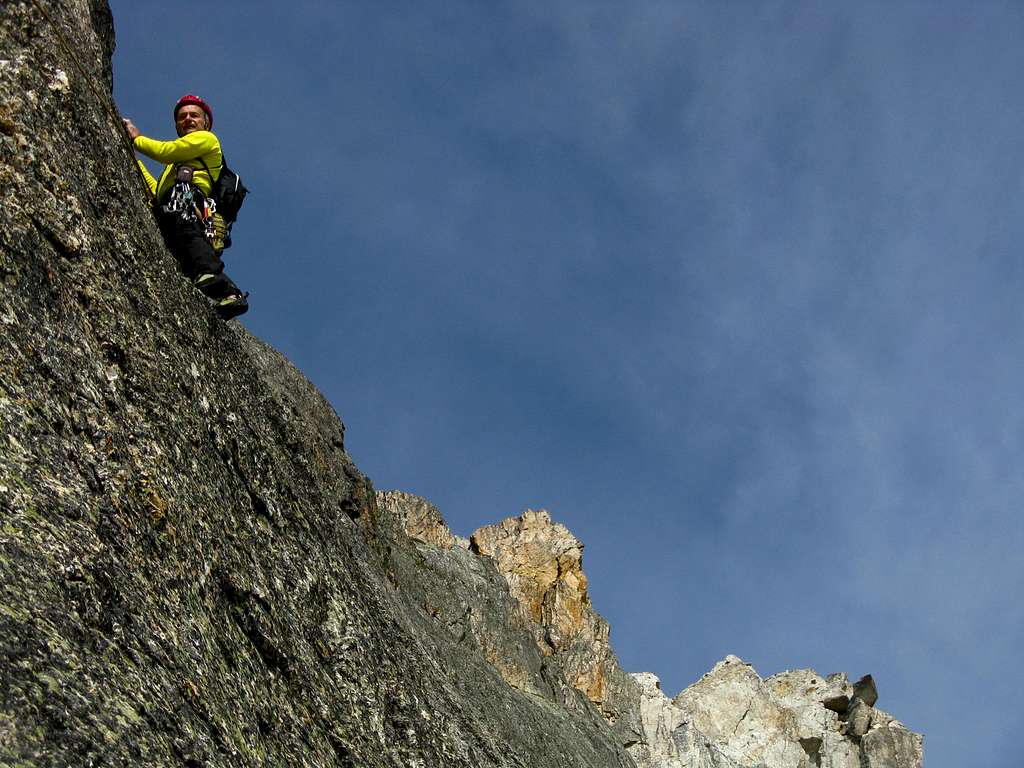


On the contrary a stunning climb runs on Aiguille Large de Mary North-East face, the interesting wall facing toward the approach path on the Vallon de Mary; it's Marinet Là, a spectacular climbing route developing on extra-quality orange and black quartzite, a hard kind of rock, plenty of flat holds. The route is equipped with spaced bolts.
Getting There
The starting point is the little hamlet of Maljasset m. 1905. The main towns in the area are Barcelonnette and Guillestre.
Road Approach

- From Barcelonnette follow the road D902 in the Ubaye Valley towards Saint Paul sur l'Ubaye; getting to Saint Paul, leave the road D902 and follow on the right the road D25 crossing Saint Paul, continuing up the valley and getting to Maljasset (mt. 1905)- Parking before the village.
- From Guillestre follow the road D902 rising to Col de Var, then descending to Saint Paul sur l'Ubaye; getting to Saint Paul, leave the road D902 and follow on the right the road D25 crossing Saint Paul, continuing up the valley and getting to the small hamlet of Maljasset (mt. 1905)- Parking before the village.
Walking Approach
From Maljasset cross the river (bridge) and follow in the beginning an unsurfaced route, then the path to Col Maurin, rising to reach a grassy terrace (m. 2045) and going into Mary Valley. At the "upper shepherd's hut" leave the main trail and go towards right, crossing the river; a good path rises towards the Marinet Lakes. A few minutes before reaching the lakes, leave the main path and take a track on the right, rising amongst rocky blocks and stones and leading below the Aiguille de Mary East face (2 hours from Maljasset). Little cairn at the bottom of the route.
Hiking
Aiguille Large de Mary Normal Route, a beatiful hike

From Maljasset cross the Ubaye river (bridge), going toward right and taking in the beginning an unsurfaced route towards Col Maurin, then a good path rising to reach a grassy terrace (m. 2045) and going into Mary Valley. At the "upper alp" mt. 2380 (a little and unguarded shepherd's hut) leave the main trail and turn to right; a good path rises towards the Marinet Lakes.


Once getting to the wide basin where the beautiful lakes lie, turn to right, following a path rising along the valley and leading to Col Large. From here turn to right and reach the summit of Aiguille Large de Mary by an easy scramble (3 hours from Maljasset).
Descent: reversing the same itinerary
Climbing: Aiguille Large de Mary East face
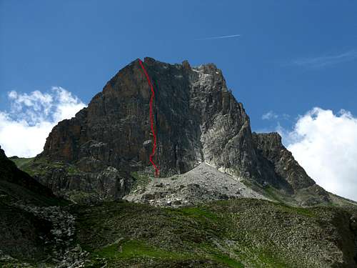
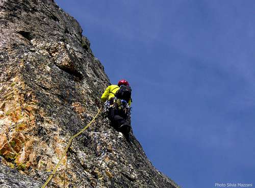
Aiguille de Mary East wall counts some interesting climbing. On SP in my section "Routes" you can find the full report of the route Marinet Là, a superb climb on fine orange and black quartzite.
Red Tape

There are no particular restrictions in climbing and hiking. Cars in Maljasset village are not allowed. Leave them in the parking before entering the village.
Huts and Campings
There is an equipped campground open in summer in Saint Paul sur l'Ubaye.

In the nice hamlet of Maljasset it's possible to stay in Refuge CAF Maljasset (French Alpine Club - CAF, mt. 1905), 60 beds, always open, phone 04 92 84 34 04.
When to hike and climb
Best season goes from July to September
Meteo
- Meteo France - Saint Paul sur l'Ubaye
- Meteo Regione Piemonte
Guidebooks and maps
Guidebooks


"Alpes du Sud, Provence" - Hervè Galley, edition Olizane
"La grimpe en Ubaye" - Colin Michel, CAF
Maps
"IGN 3538ET Aiguilles de Chambeyron - Cols de Larche et de Vars"
"IGN 3637OT Mont Viso - St-Véran - Aiguilles"