
-
 21304 Hits
-
 81.66% Score
-
 14 Votes
|
|
Mountain/Rock |
|---|---|
|
|
41.21882°N / 122.38881°W |
|
|
Siskiyou |
|
|
Hiking, Scrambling |
|
|
Spring, Summer, Fall, Winter |
|
|
6617 ft / 2017 m |
|
|
Overview
 "Castle Peak" reflects in the waters of Castle Lake
West of the town of Mount Shasta a knot of high peaks just south of Mount Eddy draw the eye. Although most of the peaks exceed 7,000 feet they are all unnamed and generally unappreciated. "Castle Peak" is the lone exception to this rule. Alone among the peaks, it is fairly easily accessed by a paved road. Moreover, a group of lakes, including massive 47 acre Castle Lake draws people to the base of the mountain to camp, fish and swim. It is a memorable image, "Castle Peak" presiding majestically over Castle Lake. As one walks to the shore, the distant edge on the opposite side of the lake is overshadowed by the grand northern face of the mountain, soaring 1,200 feet above the cobalt waters. Though this scene alone is a grand vista, "Castle Peak" hides some of its finer charms from obvious view. Tucked away in the folds of its rocky face are a cluster of smaller lakes, notably Heart Lake. Though the diminutive lake lacks the volume of its sibling, Heart Lake boasts a spectacular view of Mount Shasta.
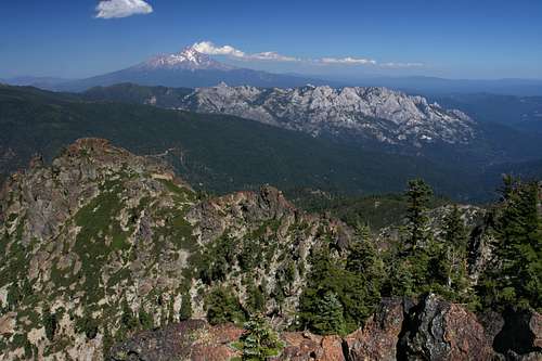
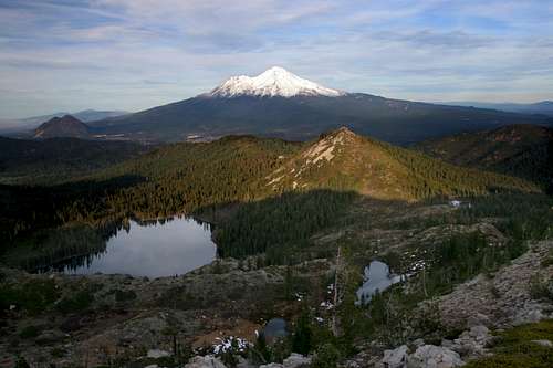 Mount Shasta, Castle Lake and Heart Lake from "Castle Peak"
"Castle Peak" lies at the nexus of the hulking Castle Crags formation and the main crest of the Trinity Divide. It is this location, at the edge of mighty Crags, as well as the presence of Castle Lake beneath its summit that has given the mountain its unofficial name. Despite lacking an official name, the peak has not escaped the attention of people, both past and present. The flanks of the mountain was the setting of the Battle of the Castle Crags, which occurred in 1855. That is the last recorded conflict in which the Native Americans relied exclusively on bows and arrows for combat. Famed poet Joaquin Miller participated in the battle. Nearly a decade later, renowned western artist Albert Bierstadt climbed the flanks of "Castle Peak" above Castle Lake to paint a scene of Mount Shasta.
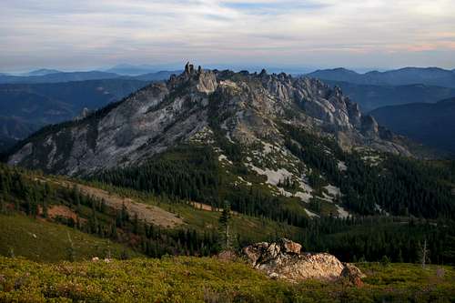 The Castle Crags viewed from "Castle Peak"
It should not come as a surprise that "Castle Peak" is one of the most scenic viewpoints in the Mount Shasta area. Particularly memorable is the view of Mount Shasta high above the Strawberry Valley, with Castle Lake, Heart Lake and other small bodies of water just below the vantage. Perhaps more impressive is the unique view of the Castle Crags just to the south. From this perspective one gets an unusual sense of just how enormous this granite jumble is. One also gets an excellent view of the Castle Spire, the highest point in the Castle Crags.
Castle Crags Wilderness
 "Castle Peak" and the Castle Crags from "Gray Rock Dome"
Located in the Trinity Divide, the Castle Crags are a familiar sight to those traveling on Interstate 5. Rising suddenly out of the forested ridges lining the Sacramento River Canyon, the serrated granite spires of the Crags are an ominously enticing formation that beckons the intrepid to explore them. Most who do succumb to the Crags allure access them through Castle Crags State Park, which is located on the southeastern corner of the formation. The majority of those who do are unaware that very little of the Castle Crags actually lie in the state park. In truth, the bulk of the Crags are found in Shasta-Trinity National Forest’s Castle Crags Wilderness. Although small, with only 10,500 acres, the wilderness area packs an enormous amount of scenery into its small area.
The eastern half of the Castle Crags Wilderness is the home of the Castle Crags themselves. Further west, the mountains get much higher than the spires of the Crags, although they remain composed of granite with occasional intrusions of metamorphic rock. Here in the western half of the wilderness area is the cluster of high peaks around the Gray Rock Lakes basin. “Harry Watkins” is the tallest at 7,200, while “Gray Rock Dome” is only a little shorter at 7,070. Another lake basin is found between the Crags and the Gray Rock Lakes, however, the main lake in the basin, Castle Lake, lies just outside the wilderness boundary. Two smaller lakes, Little Castle Lake and Heart Lake, are found inside the wilderness boundary, high in cliffs above Castle Lake, near the base of the Mount Bradley ridge, which begins in the wilderness area but continues east, beyond the boundary.
The Pacific Crest Trail travels 14 miles through the Castle Crags Wilderness’ southern flanks.
The Trinity Divide
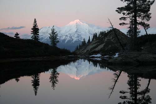 Mount Shasta from Heart Lake
The Castle Crags Wilderness is the only wilderness area in the Trinity Divide. This region is the easternmost subrange of the Klamath Mountains. Sometimes called the Trinity Mountains, the range is not to be confused with the Trinity Alps, which lie directly to the west of the Divide and compose much of the views from the PCT as it travels along the crest of the Divide. Two rivers, the Klamath and the Trinity, as well as their various tributaries, dominate the Klamath Mountains. The Trinity Alps provide the bulk of the water that flows in the Trinity River. On the other hand, while the Trinity Divide does provide some water to the river, more importantly it forms the divide between the Trinity River’s watershed and watershed of the Sacramento River. The waters on the west side of the range ultimately find their way to the Pacific Ocean by way of the Klamath River while the waters on the east side reach the sea through the Sacramento River at San Francisco Bay. The Trinity Divide is topped by Mt. Eddy, the highest peak in the Klamath Mountains.
"Castle Peak" Map
 The "Castle Peak" area
Route Information
"Castle Peak" can be climbed from a couple of directions. The primary access route begins at Castle Lake, on the north side of the peak. Information on that route can be found here. It is also possible to ascend the peak from the Pacific Crest Trail, though this route is significantly longer and is generally not worth the effort unless one is thru-hiking.Current Conditions
Current NOAA / National Weather Service Forecast for "Castle Peak"Getting There
From the town of Mt. Shasta, head west on W. Lake, crossing over I-5. At the stop sign, turn left onto Old Stage Road. After 0.25 miles, veer right onto WA Barr Road. Continue south, crossing over the dam that impounds the Sacramento River and forms Lake Siskiyou. Just past the dam, make a left hand turn onto Castle Lake Road which climbs for 7 miles to the roads end at Castle Lake.Red Tape
 "Porcupine Peak" seen from the flanks of "Castle Peak"
"Castle Peak" is in the Castle Crags Wilderness. Normal wilderness rules and ethics apply.
A permit is required for campfires.
Shasta-Trinity National Forest
3644 Avtech Parkway
Redding, CA 96002
(530)226-2500
Mount Shasta Ranger Station
204 West Alma
Mt. Shasta, CA 96067
(530)926-4511
Camping
 Mount Shasta, the Castle Crags and "Castle Peak" from the Grey Rocks
There is an excellent little campground along Castle Lake Creek, a couple hundred yards from the trailhead. This campground is small and does not have water, though water can be accessed from the creek or the lake. Other dispersed camping spots are available along the road up to the lake. A large campground is nearby at Lake Siskiyou.
When To Climb
The peak is often hikable by May though later is not uncommon. It is typically snowed in by late November. The road to Castle Lake is irregularly plowed during winter and skiing down the eastern slopes of the mountain is fairly popular. It is possible to snowshoe to the summit, but there are some dangerous cornices above the Heart Lake area.GPS Coordinates
The coordinates for the summit are : N41*13.135' & W122*23.319'. I like this type of coordinates better than the way topo zone has their's laid out so I hope this will help some of you.Thanks to Scott Armstrong for the GPS work.
 |  |  |  |
 |  |  |  |