
-
 17675 Hits
-
 80.49% Score
-
 12 Votes
|
|
Route |
|---|---|
|
|
41.22722°N / 122.3822°W |
|
|
Hiking |
|
|
Spring, Summer, Fall |
|
|
Overview
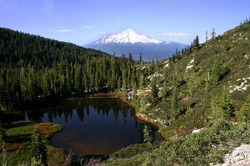 Mount Shasta beyond Little Castle Lake
The Castle Lake Trail is one of the longer hiking trails in the Mount Shasta area. Nearly 11 miles round trip, it offers up a spectacular feast of lakes and peaks as well as some of the finest views in the region. Surprisingly, once one climbs above Castle Lake, the trail is also among the least traveled in the area. In addition to being the foot route to the summit of Mount Bradley, side trips off of the trail lead to the summit of “Castle Peak” and Heart Lake. Even if one skips the detour to Heart Lake, Castle Lake and Little Castle Lake are still reached via the path. Due to its many superlative sites, the Castle Lake Trail is one of the best introductions to the Mount Shasta region.
Route Description
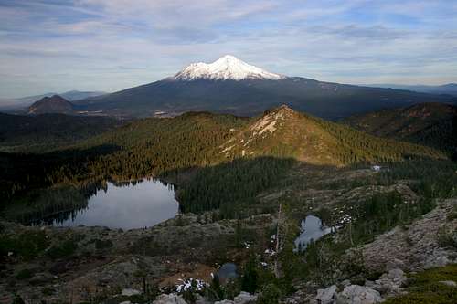 Mount Shasta, beyond Castle Lake
From the parking lot, follow the path east, crossing the lakes outlet after only 30 yards or so. Once across the creek, which is Castle Lake Creek, the trail turns south and begins climbing up the eastern wall above Castle Lake. As the route gains elevation, views of Castle Lake periodically open up through the trees. The lake is one of the three largest in the Klamath Mountains, along with Caribou Lake in the Trinity Alps, which at 72 acres is the largest, and Ukonom Lake in the Marble Mountains. The summit of “Castle Peak” is visible above the sheer granite headwall at the southern end of the lake. As one nears the top of the climb, the trees thin out and the trail becomes rockier. At 0.5 miles from the trailhead, one finally reaches a saddle 400 feet above Castle Lake.
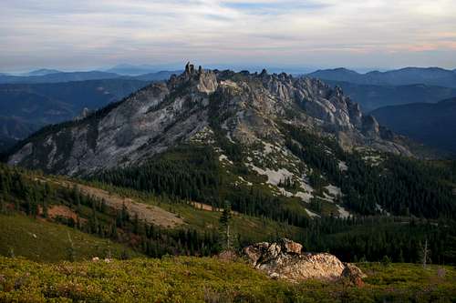 The Castle Crags from the summit of "Castle Peak"
Heart Lake and Castle Peak
At the saddle above Castle Lake, the trail turns east. However, if the intent is to reach Heart Lake or “Castle Peak” then this is the point to depart the main trail. Obvious paths have been established through the rock and brush heading west from the saddle. Soon the way leads into a grassy meadow with a high wall to the south, climbing another 300 to 400 feet. To get to the summit of “Castle Peak” simply climb this slope to its crest. There are vague routes worn into the grass and through the sparse trees. Once the top of the ridge is surmounted, a small use-trail continues west, just below the crest. Trying to stay on top of the ridge is undesirable, since it is covered in a dense growth of manzanita and huckleberry oak. Simply follow the use-trail all the way to the summit of “Castle Peak”. If Heart Lake is the destination, stay on the worn paths leading west from the saddle above Castle Lake. After a short rise, the route drops down to Heart Lake, 0.3 of a mile from the Castle Lake Trail.
 Mount Shasta from the Castle Lake Trail
Castle Lake Trail to Mount Bradley
From the saddle, the Castle Lake Trail turns east and passes along the shore of a small tarn. The pool often lasts all year, though it may dry up at the end of the season on drier years. Beyond the tarn, the trail begins to drop steeply. Water runoff has eroded the trail in some places. After descending for 0.25, the route enters a lush meadow with views of Mount Shasta peering from around a ridge. A short spur trail veers off the main route and into some trees. Beyond the glade lies Little Castle Lake. The appellation is derived not only from the lakes proximity to Castle Lake and the Castle Crags but also from its high granite headwall that is a miniature edition of the massive wall that towers above Castle Lake. Although it is not deep, the lake is attractive and a great view of Mount Shasta is to be had for those who scale the granite wall.
 "North Pinnacle" from the Mount Bradley Ridge
To continue to Mount Bradley, return to the main path, which descend another 300 feet before leveling off. At this point the trail begins a 0.5 miles stretch through a densely wooded area. This is the only part of the route that is viewless. Once the climbing begins in earnest, the crest of the Mount Bradley ridge is nigh. Upon topping out, one is treated to an incredible view of “North Pinnacle”, which is also known locally as “Castle Spire”. This granite turret is the high point of the Castle Crags formation, the bulk of which is seen to the southeast. Be sure to mark the point where the trail leaves the ridge and drops into the forest. The trail on the ridge was once an old road and it continues west beyond this point. There are usually rocks piled up to black the road and indicate where there trail turns north on the return trip, but there are no guarantees that they will always be there.
 Mount Eddy and the Eddy Range from Mount Bradley
From this point the Castle Lake Trail continues on the top of the ridge for another 3.5 miles. Although some sections passes through lightly wooded areas, it is generally open with excellent views. After heading along the ridge for 1.25 miles, the trail skirts the edge of Peak 5,783 and turns due easterly. Another mile brings the route to the top of Point 5,673. Both of these summits are higher than Mount Bradley and offer excellent views and destinations in their own rights. For many, they are better destinations, since the route from this point on follows a more obvious roadbed, rather than single-track. After descending from Peak 5,673 the trail meets the maintained road to the lookout that begins in Dunsmuir. Simply follow the road to the summit.
Map
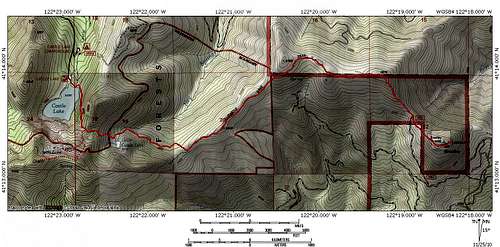 Castle Lake Trail