
|
|
Mountain/Rock |
|---|---|
|
|
33.81360°N / 116.6618°W |
|
|
Riverside |
|
|
Scrambling |
|
|
Spring, Summer, Fall, Winter |
|
|
9750 ft / 2972 m |
|
|
OVERVIEW
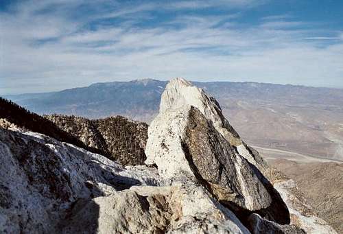
Summit block of Cornell Peak; San Gorgonio lurking in background.
Named by USGS geologist Robert T. Hill after his alma mater Cornell University; Cornell Peak was on the original 1946 HPS Peak List. This peak lies within the Mount San Jacinto State Wilderness which encompasses most of Mount San Jacinto State Park, and in addition, it lies within the Santa Rosa and San Jacinto Mountains National Monument created in 2000.
Cornell Peak is one of the more striking features seen when viewed from the Desert Divide; easily recognizable from a distance. Provides fun scrambling anytime of the year; Class 3/4 to summit block with simple route-finding and glorious views in all directions.
GETTING THERE
From Palm Springs Tram Station
From I-10 east past Banning, take SR 111 for approx 9 miles to Palm Springs Tramway Road. Turn right and drive up neverending road for approx 3.5 miles to the end and park in the tramway parking lot.
Ride tram and scream as the gondola swings over stanchions. :/ Once at the top, follow the concrete path and dirt trail to the Long Valley Ranger Station.
Approach - Continue straight ahead 200 yards to a ranger station. Pick up a day hike permit here. Carry on for about 1/4 mile to a trail junction with a sign "Round Valley - 2". Stay to the right and continue 2 miles to the water station spigot at the main trail junction in Round Valley Campground. If you use this water, please filter it.
Continue north past this trail junction for 1/2 mile to Tamarack Valley. Upon reaching a trail junction at the Tamarack Valley sign, follow the trail on the left and hike north through the campsites onto the steep slopes of the peak visible straight ahead. Head slightly to the right of the apparent summit area, passing rock barriers generally on their east side until you discern the main ridgeline ahead. Six miles round trip.
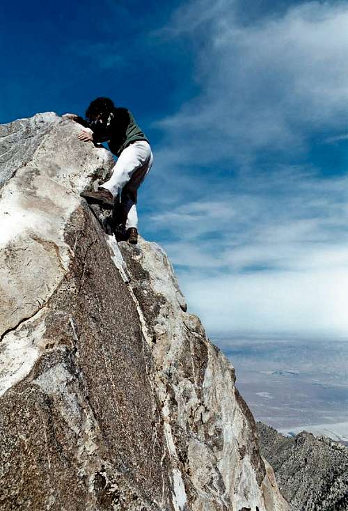
Deb on windy summit block.
From Humber Park in Idyllwild
You must first get to the quaint little mountain town of Idyllwild and find your way to Humber Park for the trailhead. Idyllwild is located on the western slope of the San Jacinto mountain range. This quiet hollow sits at 5300' with an elevation gain up to 6300' at Humber Park trail heads.
From Hemet, take CA Hwy 74E to the CA Hwy 243 junction in Mountain Center. Turn left at "Y" in road and continue on the 243 to Idyllwild.
From Banning, take I-10E to CA Hwy 243S to the town of Idyllwild.
Once in Idyllwild, follow North Circle Drive to Humber Park where the road will circle around through roadside parking and toilet facilities.
Approach - From Humber Park, start on the Devil's Slide trailhead near the toilet facilities at the turn-around parking lot. Devil's Slide will switchback a gradual incline for approx 2.5 miles to Saddle Junction, rewarding you with beautiful views of Suicide Rock and Tahquitz as you make your ascent to approx 7500'.
From the sparse wooded area of Saddle Junction, pay attention to all signs posted pointing the way to several different trails. Take the far left trail and continue up to Wellman Divide. Take trail downhill to the right (east) to Round Valley. Keep right and continue 2 miles to the water station spigot at the main trail junction in Round Valley Campground. Continue north past this trail junction for 1/2 mile to Tamarack Valley. Upon reaching a trail junction at the Tamarack Valley sign, follow the trail on the left and hike north through the campsites onto the steep slopes of the peak visible straight ahead. Aim slightly to the right of the apparent summit area, passing rock barriers generally on their east side until you discern the main ridgeline ahead. Sixteen miles round trip.
 Deb on windy summit block.
RED TRAM AND TRAIL TAPE
$21.50 for an adult round trip tram ticket. A self-issued day use permit from the State Park Ranger is required or reserved overnight permit.
TRAM INFO -
Cars depart at least every half hour from 10 a.m., Monday-Friday; 8 a.m. weekends and holiday periods. Last car up is 8 p.m. with the last car down at 9:45 p.m.
Prices and Hours Of Operation Are Subject To Change Without Notice
Wilderness permits are required under all circumstances. Permits for day hikes from the tram station can be obtained from the Long Valley ranger station. From Humber Park, they may be obtained at Idyllwild Ranger Station, as can permits for backpacking. Permits are limited to 12 hikers. The Idyllwild Ranger Station is just off SR 243 at 54270 Pine Crest Road. There is a self-issue permit stand outside of the ranger station. Permits may be obtained in advance from:
San Jacinto Ranger District
54270 Pinecrest
P.O. Box 518
Idyllwild, CA 92549
Voice: (909) 382-2921
Fax: (951) 659-2107
Be advised that parking at Humber Park will required a National Adventure Pass.
WHEN TO CLIMB IT
Cornell Peak can be climbed anytime of the year. Your choice is dependent on your skill and aptitude to suffering for mid-summer and deep winter ascents.
CAMPING
Primitive camping can be done closest to Cornell Peak at Round Valley. Running water is available at a spigot but please filter! Camping permits and trail passes are required in advance.
MOUNTAIN CONDITIONS
Current mountain weather as predicted by NOAA.
Mike Zimmerman - Feb 21, 2005 10:30 pm - Hasn't voted
Untitled CommentDriving directions for Palm Springs Tramway parking lot:
Take Interstate 10 east to 111. Merge onto CA-111 S toward PALM SPRINGS and turn a SLIGHT RIGHT onto TRAMWAY RD. End at 1 Tramway Rd Palm Springs.
The 7.5-minute USGS SAN JACINTO PEAK Quad is the map to pick-up for this route, which can be viewed on www.summitpost.com on information about Mt. San Jacinto.
Mike Zimmerman - Feb 21, 2005 11:00 pm - Hasn't voted
Untitled CommentHelmets, ropes, belay devices and harnesses will be helpful for the climb of Cornell Peak, especially if one wants to climb the summit block, and are not comfortable with the exposure on top of the block, especially in winter conditions. Bring snow shoes, ice ax, crampons, shovel, several carabiners, including locking ones, a light rack with medium pieces, i.e. hexes and stoppers, a light dry rope, 21 foot cordelette, several shoulder length slings, 1-2 1” webbing loops (15-20 feet) and mountaineering boots either leather or plastic depending on your comfort level along with winter clothing, to climb to the top of the block, especially if there is snow on the peak. If one approaches the peak from Tamarack Valley, approach up the south east slope through pine trees and higher up through manzanita (if not coverred comletely by snow), up to a class 3 rock face. Climb up the rock face for about 100 feet to the base of the summit block. Climb up a few easy blocks to the actual block. One can belay on the south side of the block in a notch and set up an anchor by tying off a horn that is on top of the north end of the block. This is a good top-rope type anchor to belay others in the party who are not comfortable with the exposure on the north side of the block, which is about 1,000 feet roughly. There are a couple of easy 4th class moves to get to the top of the block. Descent of the block can be made on belay from the top rope anchor to the base of the block, although it can be rapelled down to the beginning of the class 3 rock face, but I recommend downclimbing by the top rope anchor belay for those who wish a belay.
For those who are good solo climbers in winter conditions, helmets, snow shoes, ice ax and crampons (just in case the snow is hard or icy) and winter clothing would be recommended.
Alpineskier7 - May 7, 2022 12:33 pm - Voted 9/10
Untitled Comment-Should Be SE Face of Cornell PeakMy name on this website now is Alpineskier7, my real name is Mike Zimmerman from back in 2005. I just posted another route description on 5/7/22 for Mt Lamarck in the Sierra Nevadas. The 2005 description of the route for Cornell Peak is good and I just rated it about 4.5 stars or 90 percent. Enjoy!
Alpineskier7 - May 7, 2022 12:38 pm - Voted 9/10
Untitled Comment-Should Be SE Face of Cornell PeakMy name on this website now is Alpineskier7, my real name is Mike Zimmerman from back in 2005. I just posted another route description on 5/7/22 for Mt Lamarck in the Sierra Nevadas. The 2005 description of the route for Cornell Peak is good and I just rated it about 4.5 stars or 90 percent. Enjoy!