
|
|
Mountain/Rock |
|---|---|
|
|
43.83050°N / 114.7192°W |
|
|
10225 ft / 3117 m |
|
|
Overview

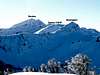
Bromaghin Peak, known to some locals in the area also as Devils Thumb, is the third highest mountain in the Smokys Range and is arguably the most defined landmark in the area. The peak's most recognizable characteristic is its hulky summit block that looks especially imressive when viewed from the north.
Bromaghin Peak is named for Captain Ralph Bromaghin who was a former Sun Valley ski instructor and member of the 10th Mountain Division, who lost his life in World War II.
When climbing, there is usually some confusion as to which peak is Bromaghin. Because there is an active SNOTEL site on Lower Titus Peak, many mistake that for the actual Titus Peak, which in turn Titus is mistaken for Bromaghin. Bromaghin is mistaken as the range's highpoint, which is unnamed on USGS maps but called Saviers Peak. This may be especially confusing if approaching via the lond ridgeline from the north. The Owl Creek Approach may also complicate some because of the various unnamed points along the ridgeline nearby that are nearly equal in heighth.
Bromaghin Peak sees its fare share of people traffic as it is often climbed in conjunction with Saviers Peak, the range's highest point. Some one, who is not knowledgable about mountain conditions, left a supposed register at the summit in 2002. The so called "register" is a small tube, like ones that float in jacuzzi and release chlorine, with about a dozen pices of loose-leaf paper wrapped in a paper bag. The pencil does not work and the paper is torn and ragged, this register will not lost much longer.
The general terrain surrounding Bromaghin Peak is quite pleasent and can be traversed with ease. The summit block is an easy class III climb from any direction and is on solid rock with well defined footholds.
 |  |
Getting There
From the pullout a small dirt road leads west toward the canyon. The road then fords the Big Wood River, which is impossible until late-summer, and even then is quite difficult. After the river crossing, the road climbs onto a high meadow into the forest next to Owl Creek. The road is in suprisingly good shape for the first 1.5 miles.
At 1.5 miles, a large tree has fallen and blocked the road. Follow the faint path that cars have made around the south side of the fallen tree and return to the Owl Creek Road. The road continues to be relatively smooth with an exception here and there of stream crossings and rock outcroppings.
Just before the road ends at about 7,900', the road is burmed up and is no longer passable by vehicles.
A four-wheel drive, high clearence vehicle is needed for this approach.
Just past the official top of the summit, there is a small pullout next to the forest on the south side of the highway. Park here.
 |
Titus Traverse Route
Route Stats
Many people appreciate this route for an approach to Saviers Peak to bag the four northern most Smoky Mountain Peaks.
From the Galena Summit pullout, look for a well defined trail that climbs the ridge to the south of the pass. The trail is in good condition until reaching Pt. 9,636. At this point, the trail begins to fade as it heads southward.
Continue over Pt. 9,921 and then onto Lower Titus Peak. This is the best view of Bromaghin Peak along the route.
Turn southeastward and continue to follow the main crest of the Smoky Mountains to Titus Peak, at 10,110'. The ridgeline makes another swing to the southwest before reaching Bromaghin Peak at .6 miles from the summit of Titus. The last few hundred feet of the summit block are on class III terrain, which has good, solid hand and footholds along the way.
 |  |
Red Tape
For the Owl Creek Approach, there is the obvious restriction of high water issues while fording the Big Wood River.
There is no red tape or permits required for this area.
The road to Galena Summit is year round.
When To Climb
Bromaghin Peak is usually snow-free by mid-July, and stays that way through late-September.
A winter ascent would be feasible via the Titus Traverse Route. However, the steep terrain near the summit would be subject to numerous avalanches.
Camping
Camping in the basin below Bromaghin Peak would provide adequate protection and beautiful views.
There are several spots along the Owl Creek Road that would be fine spots for car camping, however, camping along the Titus Traverse Route would not be a good idea due to elevated exposure.
Mountain Conditions
Bromaghin Peak is not located near any major weather reporting stations. However, the Lower Titus, Titus, and Galena Summit SNOTEL sites provide excellent information for current conditions.
For more information on current local conditions near Bromaghin Peak check out these sites.
