
|
|
Mountain/Rock |
|---|---|
|
|
43.76200°N / 114.652°W |
|
|
10336 ft / 3150 m |
|
|
Overview

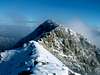
Norton Peak is the second highest mountain in the Smoky Range west of Ketchum, and, unlike most Smoky Mountain Peaks, Norton sits 1.5 miles northeast of the main crest.
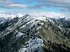
Norton Peak, with the exception of its south slopes, is a rugged peak with a rough, quarter mile long summit ridge that is nearly equal in height. Norton Peak's west and east faces are the most impressive and tower over the many mountain lakes nearby. Its long and complicated subsidary ridges are home to countless herds of mountain goats, making it almost certain that a climber will view one while climbing this peak.
Because of its location close to a trail and popular mountain lakes, Norton Peak sees its fair share of wonderous and adventursome hikers make their way to the summit. While it is not likely to share the peak with another while climbing, it is one of the more visited mountains in the area. Only one route has been reported to date and is an easy class II scramble from a nearby trail. On the summit there is a wooden structure marking the elevation and given name as well a summit register, though on a personal note, I could not find.
 |  |  |  |
Getting There
To access Norton Peak's Southwest Ridge Route from Ketchum, Idaho, drive north on Highway 75 for about 16 miles until reaching Baker Creek Road. Follow this excellent dirt road south for 6 miles until reaching the turnoff for Norton Lakes.
Follow this road about 2 miles to the a major trailhead area. Passenger vehicles should be able to make it to the TH.
 |
Red Tape
No red tape or permits required for this area. The parking passes that were once recommended at trailheads in this area are no longer needed.
Baker Creek Road is closed during winter to cars but open to snowmobilers.
Please do not approach the many mountain goats on the slopes of Norton Peak and appreciate the creatures from a far.
When To Climb
Norton Peak is usually climbed in the summer months when the hordes for locals and tourists make their way to the many lakes in the area. However, because the primary route up Norton Peak is class II, a climb in snow should not present great difficulty.
Because of access issues, Norton Peak would require a long and arduous approach during winter.
Camping
This area is a camper's dream. Not only are there more than 7-8 major lakes in the vicinity of the peak but also several spots along the trails approaching Norton.
There is also ample parking at the trailheads for these lakes. Nearby campgrounds include Baker, and Prarie Creek, as well as countless, designated camping areas along Baker Road.
Mountain Conditions
Norton Peak, like many of the Smoky Mountain Peaks, is very remote and not located near any reporting weather stations. For a good idea of what to expect generally, these links provide excellent information.
