
-
 30981 Hits
-
 97.81% Score
-
 73 Votes
|
|
Area/Range |
|---|---|
|
|
43.82200°N / 114.7123°W |
|
|
Hiking, Mountaineering |
|
|
Spring, Summer, Fall, Winter |
|
|
10441 ft / 3182 m |
|
|
Overview
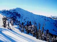
 Norton Peak
The Smoky Mountains are the forgotten mountain range of Central Idaho. They rise high above the western side of Big Wood River Valley. The cities of Ketchum, Hailey, and Sun Valley are located to the east. The range runs for forty miles in a northwest to southeast direction. The northern end of the range is where the highest mountains are located. The southern end of the range has numerous ridges and lower elevation peaks with few people. There are great opportunities for exploring the canyons in these mountains.
The Smoky Mountains in Idaho are much less known than the Smoky Mountains in Tennessee and North Carolina. The national park is probably what most people think about when they hear the name Smoky Mountains. This mountain range is considerably higher in elevation than its eastern counterpart. There are nine peaks that reach above 10,000 feet, many other interesting 9,000 foot peaks, several beautiful lakes, and a large number of mountain goats and other wildlife. It is perhaps the lakes that are the biggest attraction in the range.
The range is geographically large and complicated. It is bounded on almost every side by other mountain ranges. To the northwest are the famous Sawtooth Mountains, to the east is Highway 75 and the Big Wood River, to the south is the Camas Prairie and Snake River Plain, and to the west is the South Fork of the Boise River and the Soldier Mountains. Across Highway 75 to the northeast are the Boulder Mountains and to the east are the Pioneer Mountains. With so many mountains, you will have a great view from any of these summits.
The mountain range was formed over 60 million years ago. The Idaho Batholith was forced up above the surrounding valley. Fault blocking has caused the range to have steep east faces while the west side tends to be rolling terrain. The mountains are composed mostly of metamorphic and granite rock. Many of these layers are broken and offer fun scrambling. You can expect a lot of boulder hopping but the rock is surprisingly solid. There are mountains with 5th class cliffs and walls but standard routes are usually no more than 3rd class.
 Sunlight on Griffin Butte near Sun Valley - by IdahoKid
Getting There
The Smoky Mountains is relatively easy to get to compared to other mountains ranges in Idaho. This is due to the popularity of the Ketchum / Sun Valley area. There is a tourist feeling about these towns that is similar to Jackson Hole in Wyoming. The small town of Hailey even has its own airport. Fortunately, when you leave the cities behind you will find solitude in this large wilderness.
Idaho Highway 75 provides access to all of the trailheads for the Smoky Mountains. The road begins in the south at the city of Shoshone and continues north to the city of Challis. Many roads lead west towards the trailheads.
This page is divided into sections so that people who have never been there can understand the geography a little better. I listed the mountains below in a general north to south direction.
Thanks goes to IdahoKid for submitting most of the pages for the Smoky Mountains.
 Bromaghin Peak seen from Titus Peak - by mtybumpo
Northern Peaks
The Northern Peaks are located south of Frank & Bethine Church Summit on Idaho Highway 75. On July 30, 2006 Galena Summit was renamed Frank & Bethine Church Summit after the U.S. Senator and his wife. It is commonly called Galena Summit by most people and is labeled as both at the scenic overlook. The mountains in this area are all near the main ridgeline of the range and are connected to each other. You could combine and climb several of these peaks in the same day. The elevation of Galena Summit is over 8,700 feet.
From Ketchum, drive north on Idaho 75. In about 23 miles you will reach Galena Lodge. Continue on Highway 75 and begin a the steep windy ascent up to Galena Summit. If traveling this section of the highway in winter, it is a good idea to have snow tires or a 4wd vehicle. Once at the summit, there is a large turnout on the Wood River Valley side on your right, and then just past that, there is a little turnout on the Sawtooth Valley side of the road. There is parking for several vehicles here. There will be a sign that states "Galena Summit".
 Lower Titus Peak
 Titus Peak
Lower Titus Peak - (10,005 feet)
Lower Titus Peak is the northernmost peak in the range. It is a nice year round mountain that is a favorite place for skiers and snowshoers. The mountain sits northwest of its larger neighbor Titus Peak. The short approach from Galena Summit makes this a great mountain to climb. From the pass the route goes over Peak 9,921. It is an easy ridge walk from here.
 Bromaghin Peak
 Saviers Peak
Titus Peak - (10,110 feet)
Titus Peak is one of the major peaks in the range. It has two summits connected by a rocky ridgeline. The mountain was named after a member of T.M. Bannon’s 1915 survey party. It is 2.5 miles south of Galena Summit. This is where the standard route to climb the mountain begins. It follows the easy ridgeline to the summit. A climbers trail follows much of the route. Another route can be climbed directly from Titus Lake.
 Peak 10,337 Approach
 Owl Creek
Bromaghin Peak - (10,225 feet)
Bromaghin Peak is located 0.6 mile southwest of Titus Peak. It was named after Captain Ralph Bromaghin. He was a member of the 10th Mountain Division and a Sun Valley ski instructor. Bromaghin died during World War II. The mountain is best climbed by traversing the ridgeline from Titus Peak. There is only a short section of class 3 on this route. Another route starts from Owl Creek. This basically goes up the canyon between Bromighan and Titus Peak and then follows the ridgeline to the summit.
 Peak 10,337 Summit Camas County Highpoint
 Titus, Bromaghin, Saviers
Saviers Peak - (10,441 feet)
Saviers Peak is the highest mountain in the Smoky Mountains. The mountain was named after newlyweds Mr. and Mrs. George Saviers who climbed the mountain and 1947. It was originally named Silver Peak but a nearby peak in the Boulder Mountains already had that name so they decided to change it. The mountain is ½ mile south of Bromaghin Peak. The ridge connecting Bromaghin and Saviers Peak is the standard route. Owl Creek can also be used to climb the mountain.
Camas County Highpoint - (10,337 feet)
This is the highpoint of Camas County. It is directly south of Saviers Peak. The actual highpoint is 1,200 feet west of point 10,337. The mountain is usually only climbed by county highpointers so you will probably not see very many people here. It is a hidden summit along a ridgeline with several points. The view is good and the solitude is worth visiting this place. Owl Creek is the preferred route to the top.
 Big Lost Lake and Prairie Creek Peak - by IdahoKid
Norton and Prairie Creek
These two mountains are located between the Northern Peaks and Baker Creek. Both Mountains can be climbed from the Norton Lakes Trailhead from a side road on the Baker Creek Road. Prairie Creek Trailhead is a nice and more quiet alternative.
To get to the trailhead: Drive north, from Ketchum, on Highway 75 for about 16 miles until reaching Baker Creek Road. Follow this excellent dirt road south for 6 miles until reaching the turnoff for Norton Lakes. Follow this improved dirt road south for 6 miles until reaching the turnoff sin that reads Norton and Prairie Lakes. Follow this road for 2 miles to the trailhead and park.
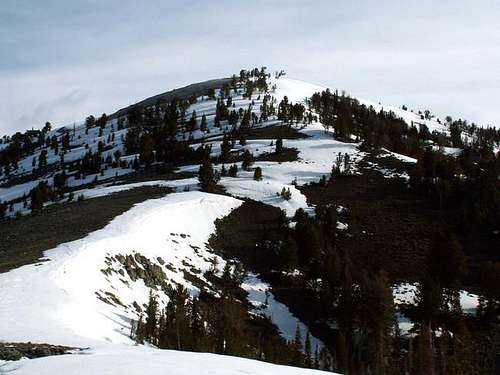
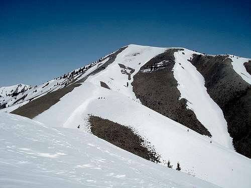
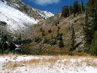
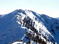
 Norton Peak Summit
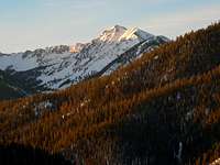 Norton Peak
Norton Peak - (10,336 feet)
Norton Peak is east of the main Smoky Mountains ridgeline. The mountain forms a huge barrier around Prairie Creek and Norton Creek. It is one of the highest mountains in the range. The trailhead is reached from Baker Creek Road. After 6 miles down the road is the turnoff for Norton Lakes. Because of its location above the Miner and Norton Lakes, the mountain is climbed often by Smoky Mountain standards. The south ridge provides the easiest route.
 Prairie Creek NE Ridge
 Prairie Creek Peak
Prairie Creek Peak - (10,138 feet)
Prarie Creek Peak is 1.5 miles southwest of Norton Peak on the main divide. It is a rugged pyramid shaped peak. The north face of the mountain can be seen rising 1,000 above Prairie Creek Lake. The south face is above Smoky Lake and its east side is above Big Lost Lake. The northeast ridge route starts from the Norton Lakes trailhead. Another route starts from the Prairie Lakes trailhead. It climbs up to the saddle below the mountain’s west ridge and then continues to the summit.
 Baker Peak seen from the ridge above Baker Lake - by BeDrinkable
Baker Creek Area
The Baker Creek Area has several nice mountains to climb. Only Backdrop Peak is climbed very often. To access Baker Creek Road, drive north from Ketchum, Idaho, on Highway 75 for 16 miles until reaching the turnoff on the south side of the highway for Baker Creek. This is a dirt road that is in good condition.
Take this turn and follow this road for 9.5 miles into the Smoky Mountains. At the end of the road is the trailhead for Baker Lake. The trail to Baker Lake is in very good condition. All mountains in this area can be climbed from this trailhead.
 Peak 10,137, Baker Peak, Backdrop Peak
 Backdrop Peak
Backdrop Peak - (10,009 feet)
Peak 10,009 just barely makes it over the 10,000 foot mark. It doesn’t have an official name but is known locally as Backdrop Peak. This is because it provides the backdrop for Baker Lake. This is one of the more popular lake hikes in the Smoky Mountains. Don’t let the crowds bother you though. There are few people once you leave the trail behind. Either of the ridges around the lake can be followed to the summit which cannot be seen from the lake. It is located further behind along the ridgeline.
 Baker Lake & Backdrop Pk
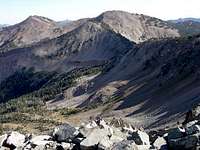 Baker Peak
Baker Peak - (10,174 feet)
Baker Peak is on the main divide southwest of Backdrop Peak. The easiest route starts from the Baker Lake Trailhead. The mountain cannot be seen from the trailhead and is hidden behind its many ridges. The direct route goes up the west fork of Baker Creek to the saddle north of the peak. The best route is to first climb Backdrop Peak and then traverse the ridge connecting it with Baker Peak.
 Bear Peak seen from the southwest - by IdahoKid
 Bear Peak area mountains
Peak 10,137 - (10,137 feet)
The southernmost 10,000 foot peak in the Smoky Mountains doesn’t have an official name. It is less than a mile southeast of Baker Peak. The mountain is seldom climbed because it cannot be seen by anyone unless they are on the ridgeline near Baker Peak. This happens to be the easiest route up the mountain. After getting to the summit of Baker Peak follow the ridgeline to the summit of Peak 10,137.
Big Peak - (10,047 feet)
Big Peak is indeed a big peak. It sits all alone to the west of the main Smoky Mountains divide. Big Peak is located far away from major roads and is considered one of the most isolated 10,000 foot peaks in Idaho. The best route is a traverse from Baker Peak. This routes leaves from the saddle to the north and goes over Point 9,956. It is another two miles from there to get to the summit ridge up the mountain.
 Bear Peak Towers
Warm Springs Creek
The Warm Springs Road leaves Highway 75 just north of Ketchum. This is a dirt road that is in good condition all the way to Dollarhide Summit. Several side roads branch off from the main road and may require a high clearance vehicle. From Ketchum, Idaho, drive to the north side of town and turn onto Warm Springs Road. Follow this road through subdivisions and past ski lifts until it turns to a good gravel road.
To get to the Bear Peak area, drive roughly twelve miles on an improved dirt road to Barr Gulch Road, marked by a brown sign that says FS (forest service) 019. From the turnoff, it is a 1.2 mile drive up Barr Gulch Road to the trailhead on a dirt road that does not require four wheel drive. To access the Dollarhide Mountain area, continue along Warm Spings Road for 30 miles on occasional rough dirt road conditions until reaching Dollarhide Summit at 8,700'.
 Dollarhide Peak
 Dollarhide Dome View
Bear Peak - (9,525 feet)
Bear Peak is one of the least climbed mountains in the Smoky Mountains. This isn’t because it is technically difficult but of its location. It is at the head of Barr Gulch and the East Fork of Thompson Creek. This is about 5 miles east of the main divide. The route goes up Barr Gulch.
 Kelly Mountain seen from the south - by Super Dave
 Buttercup Mountain
Dollarhide Mountain - (9,301 feet)
Dollarhide Mountain is on the main divide four miles south of Baker Peak. It is an easily accessible peak that is probably climbed often due to its location above Dollarhide Summit on the Warm Springs Creek Road. The route simply follows the ridge north to the summit.
Shaw Mountain - (9,650 feet)
Shaw Mountain is located 1.5 miles east of Dollarhide Mountain. It is one of the higher 9,000 foot peaks in the Smoky Mountains. Shaw Mountain is connected with Dollarhide Peak by the same ridgeline and can be combined together as a long traverse. It is a straight forward and interesting mountain climb.
 Buttercup North Face
Southern Peaks
The Southern Peaks are west / southwest of Hailey. Deer Creek Road is the usual access point to these mountains. The turnoff to Deer Creek Road is only a few miles north of the city. Croy Creek Road provides access to the south end.
To get to the Buttercup Mountain area, drive north from Hailey, Idaho, on Highway 75 for roughly 3-4 miles until reaching a turnoff for clearly marked, Deer Creek Road. Follow this paved road through a small subdivision and then across a large farm. After passing Clarendon Hot Springs, the road turns to dirt but remains quite good. Follow the never-ending and winding dirt road to the Deer Creek Trailhead near the base of Buttercup's eastern slopes. The mile is a little more rough but easily passed by any vehicle.
Primary access to Kelly Mountain is either from Deer Creek Road, or Croy Canyon Road. For access to the south ridge, take Croy Canyon road in Hailey, drive southwest for 7 miles until reaching Kelly Gulch Road. Turn north onto the road and continue for about 1 mile until the road splits. Take the right fork and go as far as your car can make it and park.
 Kelly Mountain
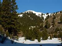 Peak 8,586
Peak 9,175 - (9,175 feet)
This unnamed mountain is 6 miles southeast of Shaw Mountain. The mountain has a summit ridge that stretches for 3 miles. It is labeled as a different elevation on every map that I have seen. Peak 9,175 can be reached from the South Fork of Warm Springs Creek Road. The north ridge can be followed to the summit.
 Bald Mountain seen from Proctor Mountain - by IdahoKid
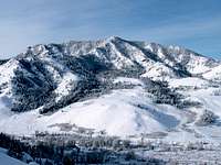 Griffin Butte
Buttercup Mountain - (9,075 feet)
Buttercup sounds like a friendly name for a mountain. It has an interesting dome shaped appearance with steep and rocky slopes. Buttercup Mountain is the southernmost 9,000 foot peak in the range. It is 2 miles south of Peak 9,173. It's located near the top of three canyons including Deer Canyon, Buttercup Canyon, and Cherry Creek Canyon.
Kelly Mountain - (8,827 feet)
Kelly Mountain is the southernmost major peak in the range. The mountain is large with a long ridgeline. It is located 6 miles southeast of Buttercup Mountain. Kelly Mountain is reached from Croy Creek Road. The turnoff is south of the city of Hailey. There are great views from the summit but the mountain isn't climbed much.
 Bald Mountain View
Ketchum - Highway 75
These mountains are located by Highway 75 and are nearby Ketchum and Sun Valley. They are lower in elevation that the other Smoky Mountains and provide year round hiking and climbing. All trailheads can be reached from side roads off of Highway 75.
Access Griffin Butte from Ketchum. Drive north of Highway 75 for 1.6 miles. Here you will see a turn off to the left for Adams Gulch Road. Wind your way through the neighborhood of mansions until coming to a three-way intersection. Go left here and follow this road till it turns dirt. Shortly after, you reach the large trailhead. To get to Carbonate Peak, from Hailey, drive to the stop light in downtown, and turn west onto Bullion Street. After a 4 way stop you will see a large parking area is on the right.
There are two main entrances to Bald Mountain, both near the Ketchum area. The first, and most popular, is the River Run entrance on the south side of Ketchum. Just follow the signs around town to get here, it is nearly impossible to miss. The other, less popular, entrance is Warm Spring north of Ketchum. On the north side of Main Street, turn left onto Warm Springs avenue and follow it to the lifts.
To access Mahoney Butte, drive north of Hailey, Idaho, on Idaho 75. Go 6-7 miles before coming to a stoplight, to the right is East Fork Canyon, to the left is Greenhorn Gulch. Go left. Drive through this neighborhood. The road then begins heading up the canyon of Greenhorn Gulch, the homes become stranger and stranger, just wait. After about 1.5 miles from the light, a sudden turn in the road leaves you with a view of Mahoney Butte. After 3.5 miles, the road changes to a nice dirt road. Drive to the end, another half a mile, and park at the trailhead.
 Mahoney Butte
 Carbonate Mountain
Griffin Butte - (8,411 feet)
Griffin Butte is located above Adams Gulch. It has more of a pointed appearance than a butte. This is one of the highest mountains near town and provides an extensive view of the area surrounding the city of Ketchum. The route up Griffin Butte starts from Adams Gulch Trailhead. The route climbs up a gully and ascends the south ridge.
 Bald Mountain
 Mahoney Butte
Bald Mountain - (9,151 feet)
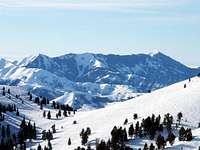
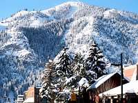
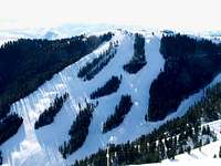
Bald Mountain is the most traveled peak in the Smoky Mountains. This is because it is the location of the Sun Valley Ski Resort. There are many downhill ski runs on its slopes. They started building the resort in the 1930's and it has been an important part of U.S. skiing history. Bald Mountain is large and seems even bigger for anyone who has climbed it without snow. There are numerous trails up the mountain.
 Smoky Lake from the Prairie Creek trail - by Deltaoperator17
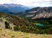 Titus Lake
Mahoney Butte - (7,904 feet)
Mahoney Butte may be low in elevation but its rugged terrain and rocky cliffs make it a fine objective. It’s located above Greenhorn Gulch west of the small intersection of Gimlet. The mountain was named after nearby Mahoney Creek. It can be climbed by its east or west face.
Carbonate Mountain - (6,714 feet)
Carbonate Mountain is the small peak directly west of the city of Hailey. It's so close that you can watch airplanes take off from airport in great detail. This is a year round mountain that is a good workout hike for anyone in the area. The best views from the summit of probably of the Pioneer Mountains to the east. A steep and well built trail can be taken right up the ridge or on a series of switchbacks.
 Upper Norton Lake
The Lakes
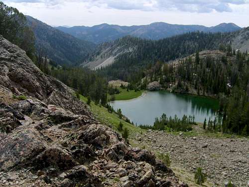
The Smoky Mountains receive a lot of snow and water each year. There are several lakes in the range. Most of these lakes can be seen on the approach while climbing a mountain. Here is a list of some of the most well known lakes in the Smoky Mountains.
 Smoky Lake
Mill Lake
Mill Lake is located northeast of Norton Peak. Drive north on Highway 75 for 16 miles to Baker Creek Road. Follow this dirt road south for 6 miles until reaching the turnoff that reads Norton and Prairie Lakes. Follow the trail up Prairie Creek until about 7,100 feet and then there will be a junction up Mill Creek. Take this maintained trail that goes all the way to the lake.
Miner Lake
Miner Lake is located west of Norton Peak. Drive north on Highway 75 for 16 miles to Baker Creek Road. Follow this dirt road south for 6 miles until reaching the turnoff that reads Norton and Prairie Lakes. Hike up the Prairie Creek trail for several miles and there will be a junction with Miner Canyon. Follow this trail to Miner Lake. The trail continues south toward Norton Lakes.
Prairie Lakes
 Miner Lake from the summit of Norton Peak - by Deltaoperator17
There are three Prairie Lakes located below Prairie Creek Peak. Drive north on Highway 75 for 16 miles to Baker Creek Road. Follow this dirt road south for 6 miles until reaching the turnoff that reads Norton and Prairie Lakes. The Prairie Creek Trail can be taken all the way to the lakes. The north face of Prairie Creek Peak rises 1,000 feet above Prairie Lakes.
Norton Lakes
There are two Norton Lakes. They are located south of Norton Peak. For the Northern Approach, drive north on Highway 75 for 16 miles to Baker Creek Road. Follow this dirt road south for 6 miles until reaching the turnoff that reads Norton and Prairie Lakes. Hike up the Prairie Creek trail for several miles and there will be a junction with Miner Canyon. Follow this trail to Miner Lake. The trail continues south toward Norton Lakes. The Southern Approach goes up Norton Creek from a junction off of Baker Creek Road.
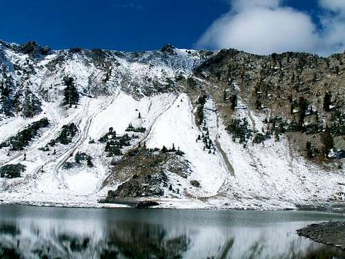
Big Lost Lake
 Bald Mountain
Big Lost Lake is located on the east face Prairie Creek Peak. The lake sits at an elevation of 9,154 feet which is a little less than 1,000 feet below the mountain. There is no maintained trail to the lake but it can be reached below the northeast ridge. This is the recommended route up Prairie Creek Peak. The shortest route is from Norton Creek.
Smoky Lake
Smoky Lake is separated from Big Lost Lake by Peak 9,339. The best route to get to the lake is from Baker Creek Road. Drive down this road until you get to the junction with Norton Creek. Hike up the canyon to about 8,000 feet. The drainage to the west contains Smoky Lake at 9,000 feet and two other smaller lakes.
Baker Lake
Baker Lake is located below Backdrop Peak also known as Peak 10,099. Drive to the end of Baker Creek Road to the trailhead for Baker Lake. It is a nice easy hike to the lake on a good trail. This is a popular destination in the area so you are sure to see people here on weekends. This is also the regular approach to climb Backdrop Peak.
 Bald Mtn Seattle Ridge
Sun Valley History
 Storm above Saviers Peak in the Smoky Mountains - by IdahoKid
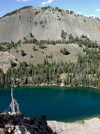 Baker Lake
Sun Valley is one of the premiere skiing areas in the United States. Developing Sun Valley was the idea of W. Averell Harriman. He was the chief executive of the Union Pacific Railroad. Harriman would later become the governor of New York. He was looking for a way to bring more tourism to the west. Since he was an avid skier, he thought building a resort would be the perfect choice. Harriman wanted something that was similiar to the ski resorts in the European Alps. He sent Felix Schaffgotsch to look for the best skiing area he could find. They checked out potential places in Colorado, California, and Washington and finally settled on the small town of Ketchum, Idaho.
Within a few months a four-story lodge was constructed and ski runs were built on Dollar and Proctor Mountains. Bald Mountain wasn’t even considered to be part of the plan because of its high elevation and steep slopes and technology wern't able to build ski runs on it yet. The world's first chairlifts were installed on Proctor and Dollar Mountains in 1936. The name "Sun Valley" was given to the area that consists of Bald Mountain, the main ski mountain, and Dollar Mountain, which is a novice and lower intermediate skier mountain. Bald Mountain is 9,151 feet high and has a vertical drop of 3,400 feet. Dollar Mountain is 6,638 feet high and has a vertical drop of only 628 feet.
Sun Valley was also used to describe the region surrounding it, including the city of Ketchum and the valley and area winding south to the city of Hailey. It became a place of the rich and famous and was similar to what Aspen, Colorado would be like years later. The small town of Hailey, which is surrounded by mountains, even has its own airport because of this. Some of the more well known people to live in Sun Valley include Ernest Hemingway, Teresa Heinz Kerry and Arnold Schwarzenegger. Warren Miller, the famous ski film producer, first visited Sun Valley in the 1940's. He has since skied and filmed movies all over the world and Sun Valley remains one of his favorite resorts.
 Bald Mountain seen from the north - by IdahoKid
When to Climb
 Kelly Mountain seen from the summit of Buttercup Mountain - by IdahoKid
Compared to other mountain ranges in the Sun Valley region, the Smokys are one of the wettest in terms of precipitation. Storms traveling across the Snake River Plain move up the canyons from the south, west, and northwest, freely without other mountain chains creating a shadow affect (similar to the Sierra and Cascades). Therefore, the Smokys are more forested and lush than the surrounding Boulder and Pioneer Mountains, which lay in the small rain shadow of the Smokys. Thunderstorms in summer, like any mountain chain, can be erratic and unpredictable so take essential gear before heading into the Smoky Mountains.
The Smoky Mountains are a year round mountain range. The majority of people hike and climb here in summer. Generally, late May to late September, is a good time to climb. Temperatures will be around 80 degrees in the summer, although the summits are usually breezy. There will be occasional thunderstorms. Expect less people during spring, fall, and winter.
Experienced climbers can climb year round. In winter the temperatures will be 30-40 degrees in the day but may be much colder at the higher elevations. Access dirt roads will be covered in snow so skiing and snowshoeing will add several miles to any approach. Mountains close to Sun Valley and near Galena Summit will be easier to access.
Here is the weather forecast for Ketchum and Sun Valley
Smoky Mountains Forecast and the Sun Valley Ski Resort webcams
 Norton Peak
Red Tape
The northern part of the range is administered by the Sawtooth National Recreation Area (SNRA).
The southern part of the range is administered by Sawtooth National Forest.
There are no fees for climbing in the Smoky Mountains.
The following rules apply:
 Titus Peak
Group size: May 1 - Nov. 30: Limited to 12 people and 14 head of stock.
Group size: Dec. 1 - April 30: Limited to 20 people and 14 head of stock.
No shortcutting of any trails
No disposing of garbage or waste
Contact Information:
Sawtooth National Recreation Area
HC 64, Box 8291
5 North Fork Canyon Road
Ketchum, ID 83340
Phone: (208) 727-5000
Toll Free: 1-800-260-5970
Sawtooth National Forest
2647 Kimberly Road. E.
Twin Falls, ID. 83301
Phone: (208) 737-3200
Ketchum Ranger District
P.O. Box 2356
206 Sun Valley Road
Ketchum, ID 83340
Phone: (208) 622-5371
[img:136093:aligncenter:medium:Kelly Mountain seen from the summit of Buttercup Mountain - by IdahoKid]
Camping
[img:130320:alignright:small:Norton Peak]There are several campgrounds located along the Wood River corridor northwest of Ketchum along Idaho Highway 75. They are open between Memorial Day weekend through Labor Day. All of them are on a first come, first serve basis, except for Boulder View and Easley which you can reserve in advance online. At all established campgrounds the cost will be around $10 to $12 per day for a single site.
North Fork Campground - This campground is located along Highway 75 near Big Wood River. It is northwest of Ketchum.
Easley Campground - Easley Campground is located near Boulder View Campground near Big Wood River. It is 14.2 miles northwest of Ketchum.
[img:122137:alignright:small:Titus Peak]
There are dozens of primitive campsites available along Baker Creek Road, Warm Springs Creek Road, and Deer Creek Road. Most campsites are clearly marked. These sites tend to fill up during holiday weekends in the summer.
Other sites include: North Fork, Wood River, and Murdock Campgrounds.
Backcounty Camping Regulations:
Camp 1/2 mile from any road, 200 feet from any water source, and 200 feet from any trail.
Camping is allowed for a period of 3 days at an individual site.
Practice leave no trace techniques.
Peak Lists
The Smoky Mountains have several peaks over 10,000 feet in elevation. They are often overshadowed by surrounding mountains. There are a lot of peaks worth climbing here. Most of these mountains are rated between class 2 and 3 hiking and scrambling.
Idaho County Highpoints List
This is a great list of Idaho County Highpoints made by SP member SawtoothSean. There are over forty peaks on this list.
| SMOKY MOUNTAINS (IDAHO) | ||
| Mountain | Elevation (Feet) | Summitpost Page |
|---|---|---|
| 10,000 foot Peaks | ||
| Saviers Peak | 10,441 | Page |
| Camas County HP | 10,337 | Page |
| Norton Peak | 10,336 | Page |
| "Robbery Peak" | 10,255 | |
| Bromaghin Peak | 10,225 | Page |
| Baker Peak | 10,174 | Page |
| Newman Peak | 10,171 | |
| "Prairie Creek Peak" | 10,138 | Page |
| Peak 10,137 | 10,137 | |
| Titus Peak | 10,110 | Page |
| "Backdrop Peak" | 10,099 | Page |
| Big Peak | 10,047 | Page |
| "Lower Titus Peak" | 10,005 | Page |
| 9,000 foot Peaks | ||
| Shaw Peak | 9,650 | |
| Bear Peak | 9,525 | Page |
| Dollarhide Peak | 9,301 | Page |
| Peak 9,175 | 9,175 | |
| Bald Mountain (Baldy) | 9,151 | Page |
| Cup Benchmark | 9,147 | |
| Buttercup Mountain | 9,079 | Page |
| Peaks below 9,000 feet | ||
| Kelly Mountain | 8,827 | Page |
| Gim Benchmark | 8,520 | |
| Griffin Butte | 8,411 | Page |
| Mahoney Butte | 7,904 | Page |
| Carbonate Mountain | 6,714 | Page |
| SMOKY MOUNTAINS COUNTY HIGHPOINTS | ||
| Mountain | County | Easiest Route |
|---|---|---|
| Camas Cohp (Peak 10,337) | Camas | Northeast Route : Class 2 |
Books and Maps
Idaho: A Climbing Guide: Climbs, Scrambles, and Hikes
By Tom Lopez. The best Idaho mountain climbing book available. There are five pages about the Smoky Mountains.
Idaho Atlas and Gazetteer
The atlas shows the area around the Smoky Mountains really well and is helpful for finding trailheads.
Fire Info
The Beaver Creek Fire was started on August 7, 2013 by lightning. Its location is west of the cities of Hailey, Ketchum and Sun Valley in the Smoky Mountains in Idaho.
Mountains affected by the fire include: Carbonate Mountain, Buttercup Mountain, Shaw Mountain, Dollarhide Mountain, Boyle Mountain, Bear Peak, Backdrop Peak, Baker Peak and Fox Peak.
Other mountains near the fire include: Kelly Mountain, Liberal Mountain, Big Peak, Norton Peak, Prairie Creek Peak, Griffin Butte, Mahoney Butte and Bald Mountain (Baldy).
External Links
Sawtooth National Forest Avalanche Center
This site has avalanche information, photos, and weather advisories for Sawtooth National Forest.
Sun Valley Ski Resort
Website on the ski resort and history of Sun Valley.