Overview
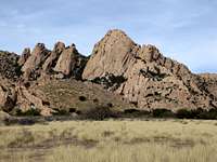
The Sheepshead is a huge granite dome located in the West Cochise Stronghold of southeastern Arizona’s Dragoon Mountains. Its west (probably more southwest) face rises an estimated 800+ feet out of the rolling prairies below. Largely uninterrupted by ledges, the face presents an awesome sight when approaching the West Stronghold. The Dome reportedly (see below) hosts 41 routes and variations most of which are likely scattered across the south, southwest, and northwest faces (these are the tallest). Majority of routes here are likely serious affairs with significant runouts. More modern lines (eg.
Stampede and
Peacemaker) tend to be better bolted and protected. Reportedly, the climbing is largely done on slabs and faces with some crack sections sprinkled in.
Getting There
The Drive:
Sheepshead Dome is located in the western Dragoons in an area referred to as the West Cochise Stronghold (area served as a hideout for the Apache Indians taunting the US Army). Take Interstate highway 10 to exit 303 in town of Benson, AZ. Follow Arizona highway 80 east (through town of Saint David) for approximately 21 miles (just past the border patrol checkpoint and a couple miles before town of Tombstone, AZ) to first left-leading side road after mile marker 315. Turn left onto (signed) Middlemarch Road (dirt and nicely washboarded) and follow it for 9.8 miles till you reach a signed turn off for West Stronghold. Make this left onto a rough (easily doable in low clearance car though) dirt road and follow it for a short distance to the first right turn. Drive past a windmill and to the road’s end at a cattle fence. Turn left and follow road for another 200 feet to the best parking spot.
The Hike:
From parking area, go through a gate (leave it as you found it) and follow the clear trail through the pleasant flat meadows (initially you shadow a fence on your left). Follow the trail for about 20-30 minutes as it meanders around small boulder hills (mostly flat hiking) and go past another cattle gate. About 5 minutes past this, look for well cairned climbers’ path (on some low angle slabs) heading right and uphill toward the base of the west face of Sheepshead. The trail puts you right at the base of
Absinthe Of Mallet route (short left facing dihedral leading to a short right facing dihedral with a barely visible bolt 30 feet up).
Red Tape
There is no red tape for parking or climbing in the Western Stronghold (
not so in the Eastern one). However, note that some formations/routes are subject to
seasonal closures due to nesting birds (generally starting after mid February). Dogs are allowed here. Please keep them under control and pack out their waste.
Camping
Free and primitive car camping is available along sections of the 10-mile road (as well as its many branch off roads) leading to the West Stronghold (see Getting There section above). Please pack out your waste and minimize impact! More campsites are available at the road's end in the West Stronghold but I am not certain if these are less primitive or if they require a fee. I would imagine that flash flooding is a concern in this area so please use caution! East Stronghold offers an established fee campground with latrine facilities (BLM) and much red tape (trailhead parking restrictions and fees).
Mountain Conditions
The good folks in the Summit Hut outdoor store in Tucson might be your best bet for climbing-specific information. The store is located on E. Speedway Blvd. about 15 minutes from Interstate 10. Their phone number and website are:
520-325-1554
summithut.com.
For general (non-climbing) area information, try the Douglas Ranger District 520-364-3468.
Routes And Guidebook Overview
The only guidebook currently in publication that lists climbing information on The Sheepshead is Bob Kerry’s
Backcountry Rockclimbing in Southern Arizona (ISBN 0-9641137-1-6). Kerry gives descriptions for the following lines and claims that a total of 41 routes and variations exist on this formation:
Crazy Fingers, 5.10d (location only)
Wish You Were Here, 5.10a (location only)
Just Say No! , 5.9 (location only)
Shock The Whippy, 5.10b (location only)
Hardskins Of Our Forefathers, 5.9 (location & description)
Absinthe Of Mallet, 5.9+ (location, description & topo)
Ides Of Middlemarch, 5.9 (location, description & topo)
Too Steep For Sheep, 5.11R (location only)
Stampede, 5.11a (location & description)
External Links
(1) Sheepshead Dome page on mountainproject.com site is
here.
(2) Sheepshead Dome page on rockclimbing.com site is
here.
(3) Brief TR on
Absinthe Of Mallet is
here.
(4) Nice series of photos from the route is
here.
(5) A
handful of nice photos from
Absinthe Of Mallet taken 2 days before we climbed the route (under perfect weather conditions).


gimpilator - Nov 29, 2015 12:06 pm - Voted 10/10
CoordinatesI just stumbled onto a strange glitch which corrupted the location of numerous pages and listed them at the same point in southern AZ. Please fix the coordinates of this page to the following, (31.8709, -109.9936). Thanks!