
|
|
Mountain/Rock |
|---|---|
|
|
39.31858°N / 119.66996°W |
|
|
Storey |
|
|
Hiking |
|
|
Spring, Summer, Fall, Winter |
|
|
7782 ft / 2372 m |
|
|
Overview
Ophir Hill lies within the Virginia Range in Storey County, Nevada. While not the tallest peak in the range; that title belongs to Mt. Davidson (7,864 ft), just ¾ mile to the southeast, the fantastic views compensate. Situated about 12 miles to the east of the Sierra and with no points higher between, the views are outstanding. The Sierra aside, fantastic 360° views encompass the Virginia Range, the entire Reno metro area, the Washoe Valley, much of the Pine Nut Mountains. Further afield, Mt. Grant, the Carson Sink, Stillwater Mountains, Tule Peak and dozens of other landmarks are visible. On a clear winter day, one may be able to see over 100 miles.  |
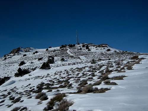
 Mt. Davidson from the summit of Ophir Hill.
Unfortunately for Ophir Hill, these unobstructed sightlines have also caught the attention of the telecommunications companies who have transformed the summit into a small jungle of radio towers.
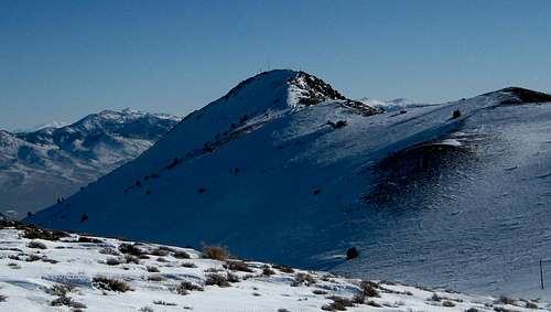
 The summit of Ophir Hill from the Spanish Ravine.
Most visitors to the peak, phone company workers aside, pass by Ophir Hill on their way to Mt. Davidson. A very easy and short (1 mile) ridge connects the two summits. Ascending from Virginia City via the Spanish Ravine Route, traversing over to Mt. Davidson, then descending the east slope of Mt. Davidson back to town, one would cover a mere 3 miles with approximately 1,700 of elevation gain. If anything, the hike is a fair workout and plus you can say you hit two named summits on your Mt. Davidson hike. So, why not?
Getting There
From Reno: Take US-395 south to Gieger Grade Road (NV-341) and go left. Continue about 13 miles to Virginia City.From Carson City: Take US-50 east for about 7 miles. Turn left on NV-341. After 3 miles the road splits into NV-341 and NV-342. Both roads end in Virginia City with NV-342 passing through Gold Hill.
From the east: Approximately 18 miles west of Silver Springs and 6 miles east of Dayton, the Six Mile Canyon Road meanders its way to Virginia City.
The Trailhead: The most straight forward route to Ophir Hill is via a network of old roads along the Spanish Ravine.
 Spanish Ravine route looking west.
 Spanish Ravine Route looking east back to Virginia City.
The trailhead for this route lies at the foot of Mt. Davidson, just below the city water tanks. From Main Street head west on Taylor Street which becomes Stewart Street. Shortly after this name change, take the first left on Greg Street. This street takes you to the foot of the water tanks and to a small city yard. There is parking for maybe 4-5 cars. See the Spanish Ravine route page for more detail on the hike.
Red Tape
No Permits required. Be sure to obey all no trespassing signs you may encounter.Camping and Lodging
There are limited developed campsites in the area. Much of the Virginia Range is private property so be mindful when making your impromptu camping arrangements away from the main roads.There are ample places to stay either in Reno or Carson City, both of which are short drives from Virginia City.
Conditions
Due to the relatively sparse precipitation in the high desert, Ophir Hill and indeed many Nevada peaks can be climbed year round. As you can see from the photos, snow can be present in the winter months. Summers can be very hot. Be sure to bring plenty of water as there is none on the hike.You may be able to get a feel for the conditions by looking at the Virginia City Webcam.

Etymology
Ophir refers to a region mentioned in the Bible from which King Solomon was supposed to have received cargos of riches.See Wikipedia - Ophir
Eleutheros - Jan 20, 2008 9:56 pm - Voted 10/10
Tule Peak or Mount Davidson?The Tule Peak page says Tule is the highest in the Virginia Range at over 8700 feet, but you state that the title belongs to Mount Davidson - so which is it? Is Tule actually in the Virginia Range? Thanks. -E
hgrapid - Jan 20, 2008 10:39 pm - Voted 10/10
Tule is in the Virginia MountainsWhoever did the Tule page made a typo. Tule is in the Virginia Mountains, often mistaken for the Virginia Range, which is the range to the east of Reno, and northeast of Carson City.
Jonodo - Jan 21, 2008 12:58 am - Hasn't voted
Re: Tule is in the Virginia MountainsThanks for the clarification.