
|
|
Mountain/Rock |
|---|---|
|
|
39.49752°N / 119.68791°W |
|
|
Storey |
|
|
Hiking, Scrambling |
|
|
Spring, Fall, Winter |
|
|
5987 ft / 1825 m |
|
|
Overview
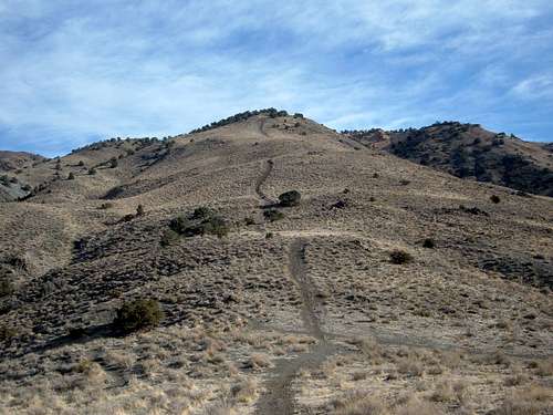
Peak 5987 is in the Virginia Range, east of Reno, Nevada. The mountain rises just to the south of I-80 and is easily accessible from anywhere in the city. It has an impressive rock face on its south flank that offers scrambling opportunities. Two primary routes hiking routes lead up to the summit; the longest requires over an hour hike (one-way) to the summit, and involves a little over 1700' of elevation gain. Peak 5987 rock face from the South
Hiking Peak 5987 is a reasonably challenging effort that can easily be done within two and a half to three hours. It is best to hike this mountain between November and March to avoid mud, snakes, and heat. The best views are enjoyed during the late afternoon/early evening.
Views from the summit are expansive, and wild horses can be seen along the route up the mountain. There is a lot of horse manure on the way up the mountain, so watch your step. It is best to hike here in late fall, early spring, or winter to avoid high temperatures, mud, and rattlesnakes.
Getting There
Trailhead for Route #1The easiest route up the mountain starts at its northwest base. The route starts at Clean Water Way which is off of East McCarren Blvd.
To get to Clean Water Way, take 395 up to exit 66 (Mill Street). Go east on Mill Street for 2.2 miles to East McCarren Blvd. When you merge onto East McCarren Blvd, get immediately into the right lane. Clean Water Way is on the right only a couple hundred yards from the intersection. There are no traffic lights to signify Clear Water Way, so you need to keep your eyes open. Once on Clean Water Way, take the road for 1.8 miles until it turns to the north. Shortly after the turn, there is a dirt trailhead on the left side of the road. There is a 4WD jeep road across from the dirt trailhead, just below a series of transmission poles. In fact, you can drive about 1/4 miles up the road to get a little closer, and give your car some privacy. I drove up about 1/4 mile with my 2WD car, but I wouldn't recommend driving up the road without a 4WD. The road is only drivable for about 1 mile with a 4WD, before running into large rocks and divets.
Trailhead for Route #2
The longer route up the mountain starts at Hidden Valley County Park, and follows the same route as Point 5768.
From McCarren Blvd, turn left on Pembroke Lane, heading towards the mountains. Take Pembroke for 1.8 miles until you see Parkway Drive. Take a right on Parkway Drive which enters Hidden Valley County Park in less than half a mile. You can park in the main parking lot (paved), or go left and find a parking spot up closer to the start of the trail.
Routes
Route #1From the trailhead take the 4WD road as it winds up the lower slopes of the mountain. Eventually you will reach a flat area where you'll find two destroyed pick-up trucks. From here, head right, up the road. Follow it up a steep slope towards the tranmission lines going up the mountain. At the top of this hill, the road curves to the right and ends at a transmission pole. Hike up the hill until you reach another road. This road winds up the mountain almost all the way to the summit.
 The road ends at the first transmission pole. From there, follow the transmission lines to the next tranmission pole, where you will reach another road. The transmission lines parallel the general route up to the summit
Round Trip hiking distance: 4.5 miles starting and finishing at the paved road
Elevation Gain: 1600 feet from the paved road
Route #2
Follow the same route up Point 5768. This trail starts just south of the water tank. From the dirt road in front of the water tank you will run into a trail. You have to walk through a fence to get to the trail, but once on the trail it is obvious you are heading the right way. The trail is quite wide, but also very steep.
 The first trail up the Colored Hills. Peak 5987 is well off to the left.
Follow the trail up until you reach a steep slope up the hill in your immediate view which represents the first lower summit, which tops out at 5,604 feet. Just before the wide trail heads up this steep stretch, take a left on a slight use trail which winds around up to the top of the steep slope. Once at the top of first lower summit, continue following the wide trail as it fades in and out up and over several hills. Keep the summit of Point 5768 in your sites. Head to the summit of Point 5768, and then walk down the slope until you reach a road at the base of the climb back up to Peak 5987.
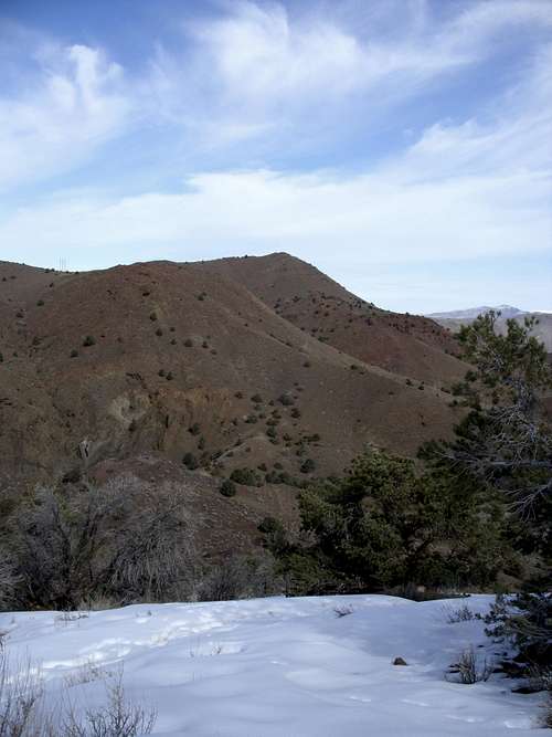 The ridge between Point 5768 and Peak 5987
While this ridge involves a 300 foot drop, it is an easy walk. There is no trail. Once at the base of the drop, the elevation is at about 5390'. A trail winds up and around the south side of Peak 5987 and ends at another jeep road. Follow the jeep road as it heads up to the summit. It is recommended to descend down the west side of Peak 5987. A road heads back down to the neighborhoods adjacent to Hidden Valley County Park. This makes the hike longer, but more gradual and easier on the body.
Round Trip hiking distance: 5 1/2-6 miles
Elevation Gain: 1700 feet
 Cairn marks the summit
Route #2 variation
You can also go straight up and scramble the southeast face, or get up towards the ridge. The way to do this is easy. From the trailhead, head towards the neighborhood below Peak 5987. Stay on the hills until you are above the road (on the right side) in between the rocky east face and the hills to the south above Hidden Valley. Get down to the road. You can either A) stay on the road until you reach a point where you hit the ridge between Peak 5987 and Point 5768, or you can scramble up the very steep east face, which involves mostly steep walking, some class 2, and possibly class 3 climbing, depending on what route you ultimately take.
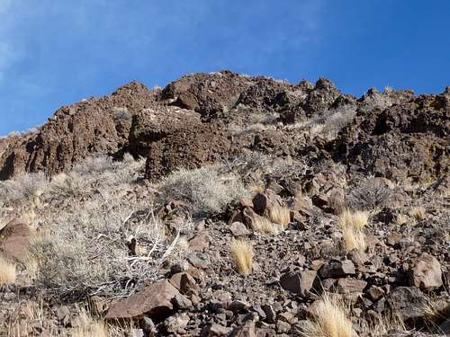 View up the steep rocks
Via the scramble route, the summit of Peak 5987 can be reached in less than 1 1/2 miles, although expect slow going due to the steepness.