
|
|
Mountain/Rock |
|---|---|
|
|
39.43792°N / 119.66115°W |
|
|
Washoe |
|
|
Hiking, Scrambling |
|
|
Spring, Fall, Winter |
|
|
6405 ft / 1952 m |
|
|
Overview
Situated just east of Reno, Nevada, Peak 6405 rises northeast of a spectacular, rocky canyon that rises east of the Damonte Ranch area of Reno. This is referred to by locals as Eagle Canyon. Northeast of the Canyon is a wide plateau that peaks at 6405 feet - thus, the unofficial title “Damonte Ranch Plateau”. It is part of the Virginia Range.
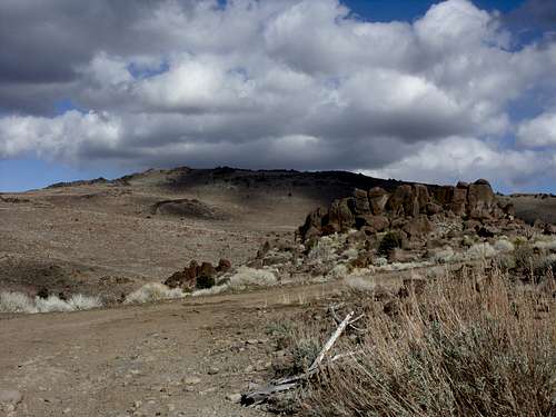 View towards the wide plateau from the road
Peak 6405 is clearly visible from the east in the Reno skyline. It is much wider than other mountains in the Virginia Range. The plateau extends about 1/2 mile north-south and 1/3 mile east-west. Hiking to the summit takes about 3 to 4 hours round trip if taking the canyon. However, a road also leads up towards the peak, and a person can jog most of the way up the road and reach the summit in a little over an hour. This is a good option for a workout if there isn’t much time and you want some excellent views close to home. The best time to hike Peak 6405 and the Damonte Ranch Canyon is late fall and early spring. During summer months, rattlesnakes like to make a home in the canyon and elsewhere on the mountain. Winter creates ice in the canyon and the mountain can get a lot of snow from December through February. It is recommended to hike in the afternoon, because the light shines on the mountains and there is greater visibility and better views.
Getting There
Getting to the base of the mountain has been a challenge in recent years due to construction near the base of Eagle Canyon. However,a new bypass trail was created to access the route. Take 395 from Reno to exit 59 –Damonte Ranch Parkway. Once off the highway, head east towards the mountainsand turn left on Steamboat Parkway. At the end of Steamboat Parkway, take aright on Rio Wrangler Drive. The canyon comes into view to the east. Take YeeHaw Way towards and continue on Trailrider Drive. Head up towards Tobiano Drive. Across from Tobiano Drive on Trailrider is a paved path. Take this paved path and cross over rocks toa trail on the other side. Alternatively, you can get to the trail without crossing the rocks. Just take aright off Trailrider at Gold Mine. Take your first left on Cavalry Circle and head up about 800 feet to the paved path.
Route Information
There are two ways up the mountain. The first is the Eagle Canyon. The second is a road that avoids the canyon, and heads up the left side of the Damonte Ranch hills directly to Peak 6405. There isn't really any advantage heading up the canyon, since Peak 6405 is to the north and is more easily accessed from the road that passes just south of it. However, you can ascend the canyon and descend the road.
If taking the canyon route, take the hikers path as it crosses the construction site, and continue untilit dies out and stay in an open area until you reach the foot of thecanyon. That is reached less than a mile. The canyon starts at about 4900 feet and climbs up to 5570 feet in about ¾ of a mile. However, this will take most hikers at least 40-45 minutes due to the difficult terrain. There is no trail, and there is lots of rock scrambling, including a few class 3 moves. Watch for falling rock, and ice during winter.
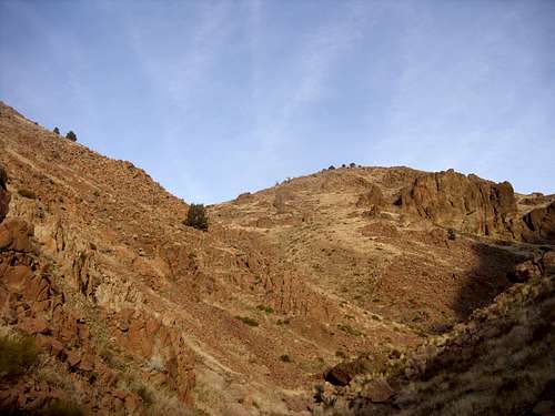 Heading up the canyon
At the top of the canyon head straight until you get to a road. Once on the road, take a left and to a ridge top to the north. At ½ mile you will find the connecting road. Head down the road, and then head back east to the back side of Peak 6405. The road curves around a prominent rocky hill and ends up directly below the west face of Peak 6405. Head straight up the face where you will encounter some rock piles. Get up to the plateau and the summit is pretty close. There are a couple of rocky piles both at similar elevation. Each can be considered the summit. If hiking this route, it is about 4 miles to the summit with a total elevation gain of about 2,050'. Hiking back down the canyon is not recommended. Descend the road. If hiking the road up, head north away from the canyon and follow the road when it swings back to the south near some power lines. This heads up to the side of the canyon. For this route, total elevation gain on the way up is 1,950' in 3 3/4 miles. The way back down is also via the road, so total round trip hiking is 7 1/2 miles.
Red Tape
If parking near the paved path,there is no trailhead. It is in a neighborhood. Just be respectful and park on the street. There are no issues or permits needed to hike up the canyon itself.