
|
|
Mountain/Rock |
|---|---|
|
|
35.27235°N / 118.09516°W |
|
|
Hiking |
|
|
Spring, Fall |
|
|
5028 ft / 1533 m |
|
|
Overview
Chuckwalla Mountain is part of the subsidiary Piute Range just north of Mojave in an area commonly known as the Tehachapis, considered the southernmost section of the Sierra Nevada. Chuckwalla Mtn shares its name with at least one other peak in California, both being named after the desert lizard, Sauromalus ater, or common chuckwalla. Chuckwalla Mtn is often hiked with its neighboring peak, Cross Mtn, as they both appear on the Sierra Club’s HPS website. Chuckwalla’s distinct double summit can be seen from south of the City of Mojave or as far north as Highway 168. After a wet winter, the valley northwest of Chuckwalla sprouts a variety of colorful wildflowers.Like Cross Mtn, the area around Chuckwalla has earned the dual reputation as an off-road recreation spot (you may find yourself sharing the trails with motorcycles) and as part of the Tehachapi Wind Resource Area. The Jawbone Canyon area near Chuckwalla Mtn was a past host to a number of mining concerns, including the White Rock Mine where rhyolite was extracted. The view from Chuckwalla encompasses the entire Antelope Valley, including a mysterious automotive track hidden from the motorists on Highway 14 below. The short 4 mile roundtrip hike from Lone Tree Canyon can make for a quick stopover hike to or from the High Sierra.
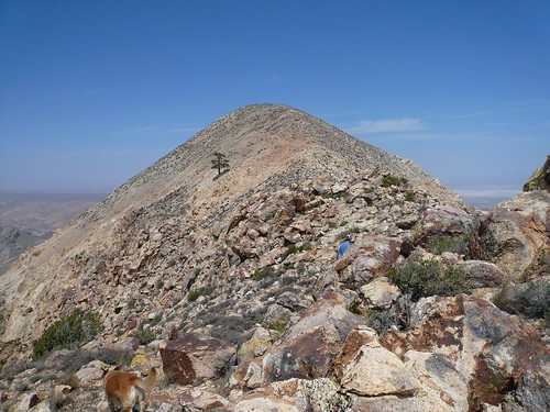
The west summit with the lone tree
Getting There
There are two approaches to Chuckwalla Mtn depending on the desired route. The primary approach, via Jawbone Canyon, is easy to find. The Jawbone Canyon Road lies 19.5 miles north of the City of Mojave off Highway 14. After turning west onto the road from the highway, proceed 6.3 miles to the point that Jawbone Canyon Road makes a sharp turn to the north. A locked gate bars further access west from this corner – park off road to access the northerly route (see current warning below).The second route is accessed through a convoluted approach (reasonable clearance vehicle required) via Lone Tree Canyon Road, 14 miles north of Mojave off Highway 14. Head west crossing under the new aqueduct pipe and then over the old pipe. Immediately turn right after crossing the old pipe to the end of the canyon where the road takes a 180 degree as it climbs out of the canyon (ignore two previous forks unless you want to examine aqueduct vents). At the top of the canyon, once again execute a 180 degree left returning to roughly a northerly direction (do not go straight). When the road makes a right turn and begins descending, take the fork to the left instead of following the main road. At this point the road becomes a bit rough but follow it up and over a bump finally parking at the point where the road wants to drop to the right again. The parking spot is obvious and lies at the foot of the steep ridge that marks the beginning of South Ridge route up to Chuckwalla Mtn. More detailed directions can be found here.
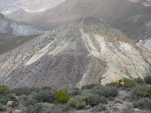
The north way down – NW ridge below
Routes
There are two common use trails that access the summit of Chuckwalla Mtn. The southern route has the advantage of starting 700’ higher that the northwestern route and is only half as long (but requires high clearance to access). As of May 2008, the approach from the northwest is prevented by a security guard (at the locked gate) for the Los Angeles Department of Water and Power’s Pine Tree Wind Development Project. Although the mountain has some cliff bands, it can literally be approached from any direction.South Slope: Class 1. This is a straight forward hike on a good use trail from a parking spot (Lone Tree Canyon) south of the west shoulder of Chuckwalla. Follow the firebreak up the steep hill until you reach a dirt road that climbs steeply east to west. Take the road to the top of the shoulder to the junction with the trail to Cross Mtn. Ascend the trail to the right, bypassing the lower western summit to the higher eastern summit. The climb up the east summit is quite enjoyable by staying on top of the rocky ridge.
Northwest Slope: Class 1. This route starts at the locked gate at Jawbone Canyon. Follow the road west for for less than half a mile turning south to follow the White Rock Mine road. Follow the road until it bends left at which point ascend the ridge to the south. This route connects with a ridge-top motorcycle track that goes to the saddle immediately north of Chuckwalla. Climb to the top of the peak (south) from the saddle.
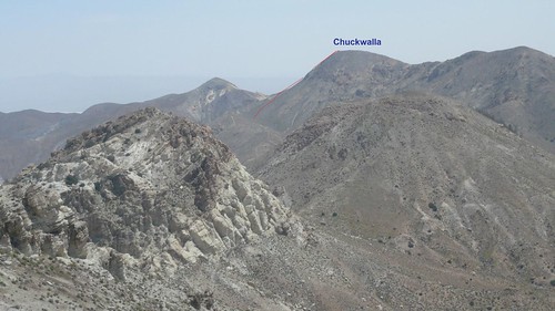
Chuckwalla’s NW slope & saddle from Cross Mtn
Red Tape , Camping, and Conditions
There are currently no permits required to access Chuckwalla Mtn. However, some of the approaches do cross Department of Water & Power property and closures may occur from time to time.Camping is best done in the canyon immediately west of Chuckwalla Mtn although sources of water may be limited. It can be also done at the barren parking spot accessed from Lone Tree Canyon.
Hiking can be done in almost any season but the late fall and spring time is best from a temperature perspective. Summer time will involve hiking in hotter high desert temperatures while a wet winter brings the danger of flash floods. Check for current weather.
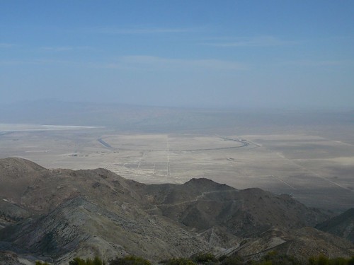
Mystery track
External Links
HPS Trip ReportsMy pics