
|
|
Mountain/Rock |
|---|---|
|
|
42.76743°N / 0.11021°E |
|
|
Hiking, Mountaineering, Mixed, Scrambling, Skiing |
|
|
Spring, Summer, Fall, Winter |
|
|
9764 ft / 2976 m |
|
|
Overview
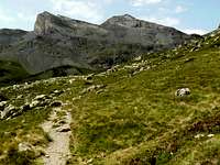 East side
 Sunrise on the peak
 From Azet
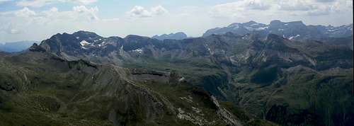
 Vignemale view
 Looking to Campbieil
 Summit & Vignemale
 Interesting flora
 ... in profusion !
Soum des Salettes, equally often called Pic des Aiguillous, is a proud limestone peak of 2976m, located at the junction of the Néouvielle region and the Monte Perdido region: it stands just south from the Campbieil, and just north from the Troumouse-Baroude peaks, in the continuity of La Munia.
Like many other major peaks of this axis, Soum des Salettes stands on the water divide between the Adour and the Garonne, more precisely between the Gavarnie valley and the Aure valley. The pass located just below the peak, on the normal route, "Port de Campbieil" (as it lies under Campbieil too), is a very famous ancient route between the two valleys, with a strong historical background.
Soum des Salettes is very easy to climb from both sides, it is a walk to the summit, which almost reaches the three-thousands. As it stands just below Campbieil, the panorama is pretty identical, just a bit closer to Monte Perdido. We can say this peak is the "easy alternative" for those who find Campbieil (already easy...) too long to climb.
 Summit view to the South Summit view to the South |
Being the small brother of Campbieil is not the only interest of this mountain. Seen from the South, its shape is spectacularly geometric, like a big cape oriented to the sun, with unbridgeable cliffs below. This view is best appreciated from the nearby Pic de la Géla that the fittests can combine the same day. One can also choose to visit only the spectacular mountain passes of Hourquette de Chermentas and Hourquette de Héas to complete a fine hiking day with interesting views.
Soum des Salettes comes from "Summit of the salts", since salt is commonly used to gather herds of sheep (sheep like salt); which suggests the mountainsides were long ago used for grazing. There is a rumour that it would come from the white color and the snow, but it is unfounded.
The other name, "Pic des Aiguillous", doesn't make more mystery, Aiguillous being similar to "aiguille", which means a striking peak.
A possible hypothese for these two names is that Aiguillous was used on the Gavarnie side, and Salettes on the Aure side, since "Val des Aiguillous" is located west.
The first ascent is not precisely known, but probably long ago by sherperds considering the easiness of the mountain, and the popularity of Port de Campbieil.
Getting There
 Blue Pyrenean Thistle
 Herds of marmots there !
 Fauna & Flora...
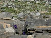 ...in every corner !
 Birds...
 Birds...
* From the Gavarnie valley
From the A64, exit at Lourdes and take the direction of Gèdre and Gavarnie. At Gèdre, take the direction of Héas and the Cirque de Troumouse. Park at Héas, 1500m, where is located a pretty chapel.
* From the Aure valley
From the A64, exit at Lannemezan, and take the direction of Arreau, and then Saint Lary. Pass it and continue until Aragnouet, where, just before the laces, a road turns right in the direction of the ski station of Piau Engaly. The resort car park is the starting point, quite high (1860m) and convenient, instead of being more romantic...
* From Spain
There is no direct trailhead from Spain to the peak, however one just needs to drive across the Bielsa tunnel and drive down to Aragnouet to reach the previously mentionned point.
View Larger Map
Routes
 From Piau
 From Héas
 Port de Campbieil
 Aiguillous valley
 Troumouse from Col de la Sède
 Hourquette de Chermentas
 Port de Campbieil and eponym mountain from the Piau valley Port de Campbieil and eponym mountain from the Piau valley |
* From Piau Engaly : very straight forward... Walk up the Vallon de Badet (or called Valley of Piau too). The trail takes some height on the right shore, before elevating to Port de Campbieil. From Port de Campbieil, walk south to the top on the steep but large ridge. One can decide, on the way up or the way down, to pay a visit to the Hourquette de Chermentas.
Variant : using the Baroude valley as a starting point, this passage can make an interesting alternative route for those who want to avoid the ski station
* From Gèdre: take the GR10 that goes to the Granges de Campbiel. This valley leads us to Port de Campbieil and the final part already described.
* From Héas : At the chapel (not at the top of the road in Cirque de Troumouse), take the trail left from the road elevating north into the Val des Aiguillous. This leads us to the pass Houquette de la Géla, between Soum des Salettes and Pic de la Géla, which allows us getting on the other side (Piau valley), near the beginning of the ascent to Port de Campbiel from East.
Variant : starting from the Cirque de Troumouse (2083m), after a visit to the lakes, a more sporty variant is possible, by reaching the Col de la Sède (severe scrambles on the Troumouse side, walking down on the other). We reach this way the upper part of the Vallon des Aiguillous.
* For the sportiest ones, amators of long-distance routes and scrambles in wild terrain: there is an interesting possibility to reach the Hourquette de Cap de Long (on the foot of Pic de Campbieil), in one wants for example to combine Campbieil to Soum des Salettes.
Most of these routes are illustrated in this excellent map from the site of Philippe Queinnec.
Red Tape
 Guarded terrain :)
 Red tape :)
The West side of the peak (route from Héas) belongs to the Parc National des Pyrénées, with its regulations.
Camping / Huts / Accomodation
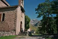 Héas Chapel
 From vallon de la GélaHourquette de Chermentas
 Goat on Hourquette de Chermentas
* Wild camping
As mentionned above, we cannot wildcamp on the west side of the mountain only, only on the east (an absurdity), as the Aiguillous valley and Troumouse belong to the Parc National des Pyrénées, and the rest not (imagine, Piau Engaly is a ski resort... it would be a nonsense !)
The Piau valley, by the way, as we get a bit further up from the trailhead, is a great place to pitch the tent for an early start.
* Huts
- An official mountain hut in the Baroude valley; a bit distant from all our routes, only convenient for the variant of the first route (by Barroude and Chermentas) : Refuge de Barroude
- A hiker's basic guesthouse over Héas and just below the Cirque, very well located : Auberge du Maillet
- A very old sherperd hut, in very bad state, in the Piau valley near the lake Badet: Cabane de Badet. Useful only in case of emergency (thunderstorms, etc)
- Two open sherperd huts in the Aiguillous valley : Cabane de l'Aguila, half way, and Cabane des Aiguillous, further up (a nice one)
- One open hut in the valley of the Campbieil barns : Cabane Sausset. Open only out of the season (spring, winter, autumn) since used by the sherperds.
- One little hut in the heart of the Troumouse valley, Cabane des Aires, superb location and ideal for the variant by Col de la Sède.
* Accomodation in the valleys / official campsites :
Check the tourist boards of :
- The Aure valley : http://www.vallee-aure.com
- The Gavarnie valley : http://www.gavarnie.com