
-
 7257 Hits
-
 82.48% Score
-
 15 Votes
|
|
Mountain/Rock |
|---|---|
|
|
42.82758°N / 0.10712°E |
|
|
Download GPX » View Route on Map |
|
|
Mountaineering |
|
|
Spring, Summer, Fall |
|
|
9957 ft / 3035 m |
|
|
Overview
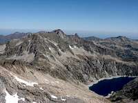


On August 15th 1787 Henri Reboul and Jean Vidal climbed a peak of 3000m in the Pyrenees. They didn't knew but it was the first ascension of a peak of 3000m in this range with documentation. They climbed the Turon de Néouvielle in order to make a map of the area but we don't know if somebody stayed on the summit before. The access to the summit is easy from the North and it's a climb very popular in the area. The right East is join to the Pic de Trois Conseillers and it's the image that you see from Cap de Long as an impressive wide wall between both summits.
Routes:
The normal route (F) is from Barèges across Refuge de la Glère spending the night the previous day in the refuge. It's a very long hike to climb in only one day. It's the perfect election to hikers.
The ridge from Pic de Trois Conseillers is easy (F.+) but it's very exposed and it's a climb only for mountaineers. The point of entry to the ridge is the Breche de Néouvielle, the important col between Néouvielle and this ridge. You have two options to reach the Breche, from Cap de Long (P.D.-, with a lot of stones, helmet is advisable) or from Refuge de la Glère (F, without path with a lot of stones, blocks and scree).
Ski cross county: In the first weeks of Spring some people use skies to the summit from Cap de Long across Breche Chausenque. It's a long but beautiful route. On summer it's not a good idea. Important: the road is close in winter and you must wait to May. June is the best month to ski generally.
Secondary summit
The aiguille South has the name Pointe Reboul-Vidal (3.007m) remembering the first climb of Turon. The easier route is the descent from the summit of Turon (F.sup.) on a sharp ridge.
 |
 |
 |
 |
 |
Getting There

Approach to Barèges:
-Barèges is a small village in the west side of the famous Col du Tourmalet, between Luz-St-Saveur and Bagnères de Bigorre. The shorter access is from the highway to Tarbes. You take exit 12 to Lourdes, Argeles-Gazost, Pierrefitte, Luz-St-Saveur and barèges. Two km after Barèges is the road to Plateau de Lienz where the road ends and it begins the forest track of 4 km to the end in a small parking. The track follows but it's forbbiden to drive.
From this point you must walk 1h30m to Refuge de la Glère (2.150m).
Red Tape
The peak is in a reserve natural with rules.Camping
Camping:The areas of camping with tent are signalled in the East side of Lac de la Glère.
Hut:
The best option is the kept Refuge de la Glère (2.150m).
Refuge Packe: free small hut in the col de Rabiet at West of the Turon de Néouvielle. The access to the normal route is without path entering in the area of Coume de l'Ours. It's a little confuse and it's not a very good idea except if you use the hut to climb Pic Long or Bugarret another day.
External Links
Igertu: Turon, interesting collection of pictures and maps of the route (text in Spanish).esquidetravesia.net: ski cross county from Lac d'Aubert (text in Spanish).
mendikat.net text in Spanish.