
-
 46463 Hits
-
 89.19% Score
-
 29 Votes
|
|
Mountain/Rock |
|---|---|
|
|
42.10990°N / 123.3112°W |
|
|
Josephine |
|
|
7048 ft / 2148 m |
|
|
Overview
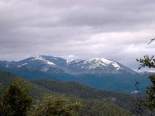
The highest point in Josephine County, Grayback Mountain is relatively unknown outside of the Grants Pass / Medford area. It is directly west of Ashland Oregon as a crow flies, part of the Siskiyou mountain range that lies in both Oregon and California. Many of the locals, however, climb this mountain frequently for the views that are outstanding. It is connected by trail to Oregon Caves national monument, about five miles away.
From-Grayback's lofty perch, views are expansive (on a clear day) in all directions with Mt. Shasta visible on the skyline to the south and peaks like Mt. McLoughlin to the east highly visible. Myriads of peaks rise to the west and southwest including one beauty, Pyramid Peak to the southwest, in the Siskiyous of California.
It's relatively close to Oregon Caves National monument and Views south to Mt. Shasta and northeast to McLoughlin reward you as you make your way up the slopes of this peak, causing you to catch your breath from time to time as a new vista opens up before you.
Getting There
If you are heading north on I-5, leave the Interstate at the Phoenix exit, and follow the signs as you work your way through to Jacksonville, and then on to Applegate. See the directions below for where to go after Applegate. (More on Jacksonville and yet more here as it has quite a bit of history and is worth a visit in and of itself.
If you are heading south on I-5, leave it at Grants Pass, go south on US199 and turn left on SR238 toward Murphy and Applegate. Just before crossing to the north side of the Applegate River at Applegate, turn right on the Thompson Creek Road and drive into Rogue River National Forest where the road becomes FR10. Then watch for FR1005 Just under 2 miles past the forest boundary, turn right on road 1005. Follow this up O'Brien Creek, staying on the north side, to the end of the road at around 4600'.
Hiking
May to November, depending on snow conditions. Conditions can be checked by calling the Rogue River Forest Ranger station. It is probable that this would be an interesting early season snowshoe hike in April or early May.
See the O'brien route description for more information on the route
 |
 |
Red Tape and other fascinating facts
You will need to fill out a wilderness permit but no fees were required to park at the TH. (note: It has been reported that a wilderness permit is no longer required) There seem to be other areas in this national forest area that require the NW Trail pass but the O'Brien TH was not posted as a fee area.
Grayback Mtn isn't named for the color of the peak or the surrounding area. It seems that at one time the early miners of this area had a name for the pest that plagued them after a long time away from the value of a good hot shower and scrubbing: Lice. Yup, Grayback refers to them nasty critters.
Birds. I have learned a tremendous amount from Bob Bolton on these amazing creatures that I pretty much took for granted. This area has quite a few birds that are not seen elsewhere and Bob was continually amazing me with his ability to identify them from not only appearance but from their songs. My favorite was "quick, two beers" but that's another story. I'll ask Bob to give me a listing of the birds that he noted here as I can't remember any of their names.
An interesting source for those interested in birds of the area might be interesting in checking this source.
Another helpful resource for anyone who'd like to know more about what's available in the hiking trail arena should go here.
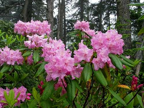
Flowers: Lots of great stuff in this neck of the Oregon woods. The Rhody pic posted is from an area further west but keep your eyes posted for the different kinds that abound here.
Critters. Nope, didn't see any Grizzlies or Sasquatch but we were looking for them just in case. Did see some pesky squirrels and heard some marmots.
Paul Klenke added this interesting information and I'll post it here in its entirety:
- Orogeny info
Author: Klenke
Date: Feb 14, 2004 1:49 PM
Grayback Mountain is located in the Siskiyou Mountains, which are a subrange of the Klamath Mountains.
Taken from Cascadia, © 1972, Ch. 10: The Klamath Mountains are a confusing range due to dense vegetation, steep un-exfoliated terrain, a monotony of lithology, a lack of fossils, and extreme structural complexity. This has not lent itself well to geologic interpretation. Still, though that be the case, the range has seen extensive mining activity. However, the mining heyday has long since passed (or the profitability of it has long passed).
"The principal metals extracted have been gold, nickel, and chromium, with lesser amounts of antimony, copper, iron, mercury, platinum, silver, tungsten, and zinc." (Nowadays [1972], barite, garnet sand, and limestone are more commonly mined.) Of all gold extracted from the region, 3/4 came from placer deposits and 1/4 came from lode deposits, the latter producing about $11 Million in gold.
Grayback Mountain itself is comprised of schist of (probably) Paleozoic age. There is a north-south belt of this schist extending down from I-5 nearly to the California border. This belt is surrounded by a much larger area of highly metamorphosed Late Paleozoic and Triassic Strata (Applegate Group). These are very old rocks indeed. They are comprised of marine sedimentary and volcanic rocks.
The Grayback Paleozoic strata are in fault contact with the Applegate Group. "Radiometric dates indicate a Late Pennsylvanian or Early Permian age for the metamorphism. The original rock was probably a rather thick section of sedimentary and volcanic strata, which might have been deposited in the Cordilleran Geosyncline or could even be Pre-Cambrian." Pre-Cambrian rocks are the oldest in the world. They are rocks that have been around (i.e. in a solid state, not necessarily at the surface) at least 500 million years.
Camping
Camping in the nearby woods is a possibility (we just found a level spot and put down our tent). No campgrounds are in the local area.
Weather information
Excellent weather information about the area of Grayback Mtn can be found by clicking here ![]()
![]()
add it here.
Trip Report for our June effort
Josephine County High Point Trip Report
Grayback Mountain (7,048 feet)
Date: June 14, 2003
Author: Bob Bolton
At Grants Pass, we drove south on US199 and turned left on SR238 toward Murphy and Applegate. Just before crossing to the north side of the Applegate River at Applegate, we turned right on the Thompson Creek Road and drove into Rogue River National Forest where the road became FR10. We turned right on FR1005 and drove to the end looking for desirable camping spots. The nearest spot to the TH was down about 0.5 mile where we found some flat ground. The weather had improved tremendously, so we left the rain fly off the tent to dry out and slept under the open mesh ceiling, enjoying the light of the full moon.
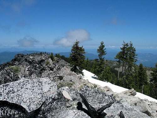
Since this was the only HP planned for Saturday we leisurely got ready and headed up the trail. At a switchback at 5,720 feet we left the trail and headed up the open slopes directly toward the summit ridge, instead of staying in the forest with many uncleared blow-downs that were hindering our progress. On the ridge we were able to find mostly easy paths through the brush, with mostly easy walking except for some stretches of small boulders. On the summit we had fabulous 360° views from Mt. McLoughlin to Mt. Shasta, and of the northern CA ranges. There was a nifty-looking alpine peak that looked quite a bit higher than us, apparently in Siskiyou County and therefore surpassed by Mt. Shasta. It would have been significantly higher than Del Norte County's HP, Bear Mountain. I haven't been able to identify this peak yet, however.
We returned by going north on the ridge and connecting to the trail where it came through the gap. There was still quite a bit of snow east of the crest, so we took advantage of that for easy walking. The trail then descended into blowdowns by the dozens and progress became very slow as we had to climb over, under, above and around to get past each one (of which there were hundreds) After realizing that the trail was not the way to go, we went back to where the trail switchbacked and here we decided to go back out onto the open slope and descend to the 5,720 switchback to avoid the blow-downs.
The remainder of the hike was uneventful, and Dean had injured his wrist just below the summit and had wrapped it in an ace bandage and packed some snow around it, kept repeating that we would still complete our trip as planned by climbing South Sister on Sunday. After eating Mexican in Medford, however, I finally convinced him to get on home and get that wrist checked out, so our trip was cut short, and we only got 4 of the planned 6 counties.
summit GPS-derived coordinates (42.11002° N, 123.31128° W) - datum?
New Trail for Grayback
Dennis Poulin sent me a link to a newspaper article about a new trail that was built for Grayback Mtn. I'll try and get more info about it so you can know more about another possible way to get to the summit. Here is the blurb from the paper as it was printed:
October 11, 2006
Grayback Trail will be dedicated on Saturday
WILLIAMS — The six-mile Grayback Mountain Trail, built by volunteers and federal employees, will be dedicated Saturday at the Brushriders Arena.
The event will begin at 1 p.m. at the arena, 155 Davidson Road, Williams.
The trail, which provides a low-elevation access point to thousands of miles of mountain trails, was created through a partnership with the community of Williams, environmental activists, recreationists and the U.S. Bureau of Land Management and U.S. Forest Service.
"The BLM appreciates the hard work and dedication of the Williams community and our partners to make this trail become a reality," said Abbie Jossie, field manager for the Grants Pass Resource Area.
The idea for the trail was hatched in the mid-1980s by local equestrian groups and the Rogue Group Sierra Club. Work began in 1989.
Advertisement
Since 1990, volunteers have worked on the trail periodically, including three National Public Lands Day events from 2000 to 2002.
The Grayback Mountain Trail is now connected to the Forest Service Boundary Trail and the Pacific Crest Trail. It also provides access to the Oregon Caves and the Red Buttes Wilderness.
The trail is open to hiking, horseback riding and mountain biking.
Josephine County Oregon
From Wikipedia, I found the following information to give us a little insight into the background of this county.
According to Oregon Geographic Names, the county was probably named after a stream in the area called Josephine Creek, which in turn is probably named after Virginia Josephine Rollins Ort. As of 2000, the population was 75,726 and the county seat is Grants Pass
Economy
Most of the commercial activity during the territorial period centered on gold mining and the supply of provisions to miners. Miners had been active in the Rogue and Illinois Valleys since 1851. By the late 1850s, however, gold mining was beginning to decline and the population dwindled as well. In 1859, gold was discovered along the Fraser River in British Columbia and numerous people left Josephine County to search for valuable claims there.
Josephine county shares with Jackson the Rogue Valley and Applegate Valley wine appellations. The U.S. government is landlord of the majority of the land within the county boundaries, with the Bureau of Land Management owning of 28% of the lands within the county boundaries, most of which are Oregon and California Railroad lands, and the Forest Service in possession of 39%.
History
The discovery of rich placers at Sailor Diggings (later known as Waldo) in 1852 and the resulting gold rush brought the first settlers to this region. Several U.S. Army forts were maintained in the county and many engagements during the Rogue River Indian War (1855-1858) took place within its boundaries.
Josephine County was created by the Territorial Legislature on January 22, 1856, from the western half of Jackson County. It was the nineteenth, and last, county created before statehood.
The county seat was originally located in Sailor Diggings, but in July of 1857 was relocated to Kerbyville, situated on the main route between the port of Crescent City, California and the gold fields. In 1886, the county seat was finally relocated to Grants Pass, a new town on the railroad that was completed through Oregon that same year.
Although several tribes of Native Americans lived in the area from which Josephine County was created, most of their members had been moved to the reservation at Grand Ronde by the end of the Rogue River Indian War. Soon afterward all Indians in southwest Oregon, with the exception of a few tiny bands, were moved to the Coast reservation (later known as the Siletz Reservation).
Josephine County was also the home to a large Chinese population. Most had come to the area to work gold claims purchased from whites no longer interested in working them. Even though they could not own land, they had to pay a tax to mine gold, and were relegated to inferior claims.
Great trip report
Bob Burd has put up his usually great TR complete with pictures and map at this location.
Jack Arendt - Sep 15, 2005 1:07 pm - Hasn't voted
Untitled CommentAs of 09-15-05, a wilderness pass is no longer needed to climb Grayback.