
|
|
Mountain/Rock |
|---|---|
|
|
40.75911°N / 110.71707°W |
|
|
Summit |
|
|
Hiking |
|
|
Summer, Fall |
|
|
12242 ft / 3731 m |
|
|
Overview
North Yard is located in the Uinta Mountains of Utah between the Left Hand Fork and the Right Hand Fork of the East Fork of the Bear River. It has no official name and is referred to as North Yard because it lies just north of Yard Peak. At an elevation of 12242 feet it is number 86 on Scott's list of Utah peaks over 12000' with at least 200 feet of prominence. Early morning on Yard and North Yard
Like the other peaks in the area, North Yard is composed of loose rock and unstable cliffs.
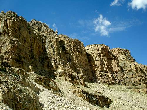 East side cliffs
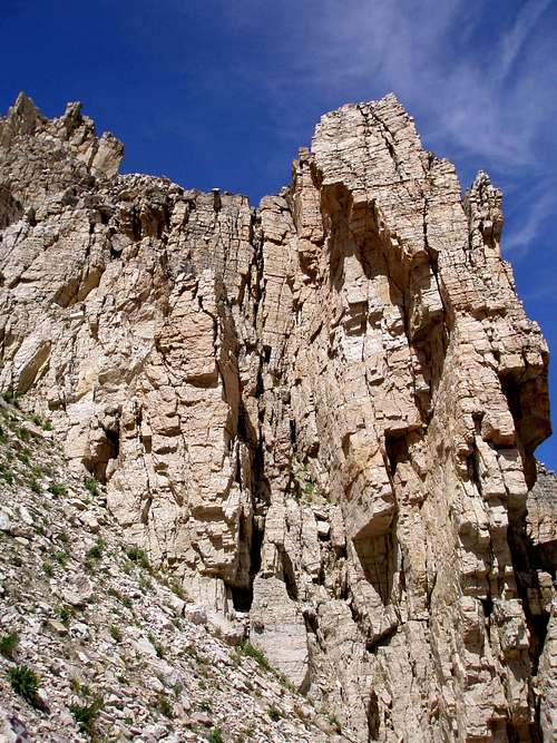 South end of the cliffs
While Yard Peak has a reddish tint, North Yard is yellowish when viewed from afar. There is a very distinct dividing line between the two.
 Yard on left, N Yard on right, from the east
 N Yard on left, Yard on right, from the southwest
From the summit area, there are great views of Beulah, the ridge leading north to the Cathedral, Dead Horse Peak, and Yard Peak.
 Mount Beulah (12557')
 Ridge leading to "The Cathedral" (12224')
 Dead Horse Peak (12642') and Yard Peak (12706')
Getting There
 On the way
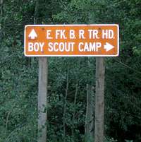
Access is via the East Fork of the Bear River Trailhead which is reached via forest roads 058 and 059 off of the Mirror Lake Highway which runs between Kamas, Utah and Evanston, Wyoming. Between mile markers 48 and 49, watch for a sign that says "E. Fk. Boy Scout Camp 6" and a smaller sign below that says 058. Turn east onto forest road 058. Drive 1.7 miles until you see another sign that says "E. FK. Trailhead 5". Turn right/south onto forest road 059 and drive 4.5 miles until you see a third sign that says "E. FK. B. R. TR. HD.". Bear left and drive .5 miles to the trailhead where you will find an outhouse and an information board.
The trailhead is just under a 2 hour drive from Salt Lake City.
Red Tape
There is a fee for parking at the trailhead as well as anyplace along the Mirror Lake Highway. You can buy an annual pass for $45, a 7 day pass for $12, or a 3 day pass for $6. You can also purchase an Interagency Annual Pass/America the Beautiful for $80 which is good locally for the Mirror Lake Highway and American Fork Canyon, as well as all Forest Service, National Park Service, Bureau of Land Management, Bureau of Reclamation, and US Fish & Wildlife Service sites charging entrance or standard amenity fees. Considering that the annual pass for just the Mirror Lake Highway is $45, the $80 pass good everywhere is a real bargain. The $45 and $80 passes can be purchased at the Kamas Ranger Station at the beginning of the Mirror Lake Highway in Kamas. The $80 pass can also be purchased at the customer service desk at REI. The $6 and $12 passes are available all along the highway in self pay tubes.Camping
 Allsop Lake
There are numerous established campgrounds along the Mirror Lake Highway. The Bear River Campground and the East Fork Campground are both located just south of the turnoff to the trailhead and are the closest. There really isn't any good place to set up a tent right at the trailhead since it was burned out in 2002 and there are no bare spots since many small aspens have sprung up right on top of one another.
On a multiday hike you have your pick of where to camp along the trail. There are many flat, grassy areas. Allsop Lake at the end of the Left Hand Fork Trail is particularly nice. Check the message board at the start of the hike to see what the current camping restrictions are.
When to Climb
 N Yard, Yard, and S Yard April-30-2009
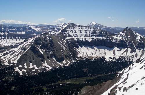 N Yard, Yard, and S Yard June-27-2009
The best window of opportunity is late June through the beginning of October.
The Mirror Lake Highway is typically closed from mile 14.6 to mile 48 from sometime in November until enough snow melts in the spring/summer. Exact dates vary from year to year. The plowing stops on the eastern end at the turnoff to the trailhead. This turnoff is not plowed and is gated so a winter ascent would require an additional 6 miles each way, just to get to the trailhead. In 2009 the gate was opened the first week of May.
Route
Starting from the East Fork of the Bear River Trailhead, there is a trail on either side of the ridge that North Yard is on. Each side also has a scree slope leading to the saddle between North Yard and Yard that can be accessed from the corresponding trail.East side West side
I did a loop following the trail on the Right Hand Fork, ascended to the saddle, climbed the peak, descended the scree slope on the other side, and then hiked out via the Left Hand Fork Trail. The east slope is significantly better behaved than the west one. Going up from the west was slow and tedious as there were sections that were very gravelly and each step had to be packed down. On the east side, the stones and rocks were firmly embedded in hard packed dirt much of the way and hardly moved at all.
From the saddle it is straightforward to head north to the summit. Shortly before the summit there is a convenient gap in some small cliffs that one can walk through. Many Uinta peaks have similar fissures near their summits.
 The gap
You need to be careful on the summit block because although the scrambling is easy, there are numerous loose rocks poised to fall on your head.
 The summit block
This route is 18.6 miles long with a total elevation gain of 3670'. It took me about 10 hours round trip.
 Map
Map