
-
 6791 Hits
-
 85.87% Score
-
 21 Votes
|
|
Area/Range |
|---|---|
|
|
46.51541°N / 10.54413°E |
|
|
Mountaineering, Ice Climbing, Mixed |
|
|
Summer, Fall |
|
|
12812 ft / 3905 m |
|
|
1 - Overview
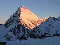
 Ortlerhauptkamm from Madritschjoch Ortlerhauptkamm from Madritschjoch |
The Ortler / Ortles Group is one of the largest mountain ranges of the eastern Alps and also one of its tallest. Out of its ten (or eleven) subgroups the smallest but in no way least important one is located in its centre - a single ridge running north to south: Ortlerhauptkamm / Cresta Principale dell'Ortles (Ortler main ridge). It contains the two highest mountains of the group, Königspitze / Gran Zebru and obviously Ortler / Ortles. Together with Monte Zebru they form the famous Ortler / Ortles trinity (see signature picture). In addition to these three high mountains there are half a dozen lesser ones, mainly on the northern and southern part of the ridge but also on the shorter and steeper side ridges.
The boundaries of the group are well defined: in the north the ridge starts south of the hamlet of Gomagoi (where the Sulden / Solda road turns of from SS38 to Stilfser Joch / Passo dello Stelvio. The eastern boundary is Suldental / Valle di Solda, which ends in Langenferner Joch / Passo del Cevedale. From here the southern boundary is formed two high valleys leading to Passo del Zebru and down into Valle dello Zebru. The western boundary is Valle Rin Maré, which crosses Ortlerpass / Passo dell'Ortles and across Unterer Ortlerferner / Vedretta bassa dell Ortles into Trafoital / Valle di Trafoi
 |  |  |
Speaking of boundaries: Today the border between Südtirol / Alto Adige and Lombardia runs across the Ortler / Ortles Main Ridge, which is also the language border between tthe German and Italian speaking populations of the area. Hence the double names of most of the summits while the less important ones often only carry one name. Before WW I this was also the border between Austria and Italy making Ortler / Ortles the highest Austrian mountain. During the war the border was heavily contested and the front ran across the area. There was a fighting position close to the summit of Ortler / Ortles, remnants of which can still be seen today. After the war Südtirol had to be ceded to Italy so that now Großglockner has become Austria's highest mountain.
Naturally a lot of mountaineering history has been written in this area and some of the alpinistic feats have become classic routes. Hintergrat, the Ortler / Ortles south-east ridge is one of them, Suldengrat, the Königspitze north-east ride another one. The north faces of Ortler and Königspitze are among the most important (and longest) ice climbs of the eastern alps and will be climbed by more than a hundred parties each year. One of the legendary feats was the climb of Schaumrolle, a massive Serac above the north face of Königspitze, which was successfully performed in 1956 by Kurt Diemberger, Herbert Knapp and Hannes Unterweger, the first ascent of which subsequently has become contested between the three. The latest incarnation of Schaumrolle collapsed in 2001 taking with it 7000 cubic metres of ice.
 |  |  |
Unlike most other high ranges in the central Alps, Ortlerhauptkamm is not made up from eruptive rocks. The mountains rather consist of limestone and dolomite and thus (geologically) can be seen as the south-eastern outcrop of the "Engadin Dolomites", the Sesvenna Group, to which it is connected across Stilfser Joch / Passo dello Stelvio. However,, the consistency of the rock differs from what you usually find in the northern and southern limestone Alps. At some time during their formation the sedimental rocks must have been exposed to temperatures above 400°C, which only happens if ther rock is buried deep beneath other layers. Thus geologists conclude that the Ortler Dolomite was formed earlier and formed a base for the newer sediments of the northern limestone Alps. Layers tilted anthe layers were left in their current locations.
2 - Ortlerhauptkamm / Cresta Principale dell'Ortles on SP
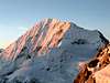
 The northern part of Ortlerhauptkamm seen from Kanzel
- Ortlerhauptkamm / Cresta Principale dell'Ortles
3 - The Summits
 |
- Stierberg / Monte Toro (2243m)
- Hochleitenspitze / Punta Alta (2798m)
- Bärenkopf / Monte dell’ Orso (2942m)
![]()
- Tabarettakogel (2590m)
- Tabarettaspitze / Cima Tabaretta (3128m)
![]()
- Tschierfeck (3316m)
- Monte Ciel (3465m)
- Ortler / Ortles (3905m)
![]()
- Pleißhorn / Corno di Plaies (3155m)
- Hintere Wandln / Crode di Dentro (3619m)
- Hintergratkopf / Punta del Coston (2802m)
![]()
- Monte Zebrù (3735m, 3724m)
![]()
- Cima della Miniera (3402m)
![]()
- Königspitze / Gran Zebrù (3851m)
![]()
- Cima delle Pale Rosse (3446m)
![]()
- Kreilspitze / Punta Graglia (3391m)
![]()
- Schrötterhorn (3386m)
![]()
- Suldenspitze / Cima di Solda (3376m)
![]()


4 - Getting There
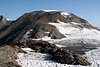
 Ortlerhauptkamm seen from Graun
- Sulden / Solda
- Take Brenner Motorway A12 to Bozen Süd / Bolzano Sud
- Switch to SS38 through Vinschgau / Val Venosta.
- For the Martell / Martello trailheads turn south onto SP2 at Latsch / Laces
- For Sulden / Solda drive through Spondinig / Spondigna and Stilfs / Stelvio.
- Shortly afterwards turn south on a side road to Sulden / Solda
- Val dei Forni
- Take SS38 northwards to Bormio
- Turn onto SS300 south to Santa Caterina di Valfurva
- Turn east into Val dei Forni
- Take SS42 to Ponte di Legno
- Turn north onto SS300 to Santa Caterina di Valfurva
- Turn east into Val dei Forni
5 - Accommodation
- Lombardia (select region "Lombardia" and/or town "Bormio")
- Vinschgau / Val Venosta
6 - Red Tape
The Ortlerhauptkamm / Cresta Principale dell'Ortles belongs to Nationalpark Stilfser Joch / Parco Nazionale dello Stelvio. See the following link for more information:7 - Weather Conditions
8 - Maps & Books
8.1 - Maps
- Nationalpark Stilfserjoch / Parco Nazionale dello Stelvio
Kompass Map WK072
1:50000
ISBN: 3-85491-391-5
- Vinschgau / Val Venosta
Kompass Map WK52
1:50000
ISBN: 978-3-85491-058-9
- ORTLES-CEVEDALE / ORTLERGEBIET
Tabacco Map 008
1:25000
ISBN: 978-8883150081
8.2 - Books
- Vinschgau
Rother Wanderführer
Rother Verlag
ISBN: 978-3-7633-4204-1
- Vinschgau / Ortlergruppe
Kompass Wanderbuch 950
Kompass Verlag
ISBN: 3-87051-404-3
- Ortleralpen
P. Holl
Alpenvereinsführer
Rother Verlag
ISBN: 3-7633-1313-3