
-
 9538 Hits
-
 81.84% Score
-
 14 Votes
|
|
Mountain/Rock |
|---|---|
|
|
42.67590°N / 0.1607°W |
|
|
Spring, Summer, Fall |
|
|
8887 ft / 2709 m |
|
|
Overview
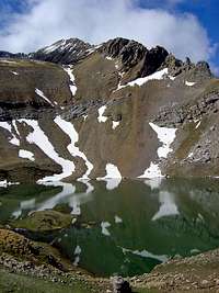
 Otal
Otal Otal
OtalThe peak Otal is an important mountain of the eastern side of the range of Tendeñera, one of the most classical of the western Pyrenees. Located in the south of valley of Tena in the east of the range of Partacua (with the popular Peña Telera), it’s a place low visited generally because the nearest of the first 3000 meters of the mountain chain, specially the peaks of Panticosa (Garmo Negro, Picos del Infierno) or the valley of Ordesa (Monte Perdido, Taillon,...) one of the most beautifull valleys of the Pyrenees.
The access to the summit is completely different in summer but generally in the early of the season you must 2 possibilities to choice, the coulouir of snow (45º) or the rock-climb grade II. In summer the coulouir without snow it's a ramp of grade I+ and it's easiest. The last meters to the summit in the ridge are exposed with grade I+.
Another names in some maps: Arañonera, Pico Otal, Peña de Otal (the name Otal is also the same of a village near of this mountain)
 |
 |
 |
 |
Sierra de Tendeñera
 Sierra de Tendeñera
The range of Tendeñera it's a place to discover for many mountaineers, with high mountains and spectacullar ridges, with a great variety of climbs. The hardest peaks are Otal and Tendeñera with some rock-steps of grade II and greats views of Ordesa, but the easiest routes to Sabocos and Peña Roya are nice climbs to mountaineers. In my opinion the peaks of this range are generally only for mountaineers with rocks, free stones, hard effort, important slope... but a lot of walk-ups to the pretty lakes (ibons) exists for all the people.
 Peña Roya
The list of the peaks of range of Tendeñera from East to West:
Fenes (2524m)
Otal (2709m)
Tendeñera (2853m)
Mallo ras Blancas or Ripera (2835m)
Forato os Diaples (2715m)
Mallo ras Peñas (2662m)
Peña Sabocos (2757m)
Peña Roya (2578m)
Peña Blanca (2556m)
Others peaks with more of 2000meters exists but generally are seccondary summits out of the main line of the range (Mandilar, Tozal de las Comas, Mondeniero, Punta Puñero, Toronzué, Pico Royo, Pico Turbón, Pico Zebollar...)
 |
 |
 |
 |
 |
Getting There

*Approach to Panticosa (northwest of the range):
Approach to Sabiñanigo by N-240 (west, from Pamplona across Jaca) or N-330 (south, from Huesca). In Sabiñanigo, C-136 to Biescas and after the dam of Bubal turn to right to village of Panticosa.
-Normal routes from there: Peña Roya, Sabocos.
*Approach to Bujaruelo (northeast of the range):
In Biescas, C-140 to Linas de Broto and Torla.
-This place it’s located in the popular valley of Ordesa, you can consult the page of Monte Perdido for more information.
-Normal routes from there: Otal, Tendeñera (from Linas de Broto)
Link to map of Via Michelin
 |  |  |
When To Climb
April-june es the best epoch for the climb still with snow in the coulouirs. The easiest season is july-september without snow but you have a lot of stones in the route.In some days of winter it's an interesting winter-climb as well but the last meters to the summit after the coulouir are exposed and dangerous with ice (rope, crampons and ice-axe)
 |  |  |
Camping
No fees, camping not allowed in the area, not huts.Campings:
-Camping of Bujaruelo
Refuge:
-Mesón de Bujaruelo
Hotels:
-Many hotels and mountain's lodges in the village of Torla.
Mountain Conditions
I.N.M.: see province of Huesca in CCAA. Search in "localidades" the village of "Torla" for the weather conditions of next 7 days.WebCam of Ordesa
External Links
- Valle de Broto
Information about the valley of Broto (spanish)
- Lospirineos.com
Information of tourism with hotels, restaurants, refuges, maps...(spanish)