
-
 5233 Hits
-
 81.84% Score
-
 14 Votes
|
|
Mountain/Rock |
|---|---|
|
|
42.68086°N / 0.20041°W |
|
|
Download GPX » View Route on Map |
|
|
Mountaineering |
|
|
Spring, Summer, Fall |
|
|
9360 ft / 2853 m |
|
|
Overview
 Tendeñera and Otal
The highest point of the range of Tendenera or Tendeñera is a spectacular rocky summit of form trapezoidal, slender and with powerful edges. The range, aligned of W. to E., the same as its western neighbour, the range of the Partacua, it's found split of the Pyrenean axial chain possessing because of it the privilege of magnificent views. Its mountains reach important heights of imposing form on the valleys, being the main from W. to E. : Peña Blanca (2,556 m), Peña Roya (2,578 m), Peña Sabocos (2,757 m), Mallo de las Peñas (2,662 m), Forato des Diaples (2,715 m), Ripera or Mallo de las Blancas (2,823 m), Tendeñera (2,853 m) and Otal (2,709 m). It exists many other smaller summits, several of them also above the 2000m.
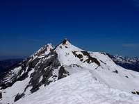 East face
A lot of people have impressed by the great slope to gain and the long routes that show the maps and many mountaineers will disdain its ascent, more still because the peak do not reach the mythical 3,000 m, but the pyreneist can enjoy of a great mountain. The fact that none of the trails of approximation be open to cars, it does neither help, for which you can opt for the overnight one in some of the tumbledown refuge or to try to obtain the permission or the key in some of the local City Hall (it's very difficult). Considering normal a single route in a mountain less frequented and far away of the accesses is a difficult work, each one should elect the one that prefer according to its capacity, since the surest one is the most technical one, but always required a good physical form. All the routes across the N. or the E. will require a short air crossing to arrive at the main top.
 |
 |
 |
 |
The two most popular routes:
-Linás de Broto (1232m): 4h 45 min. (F.)
-Yésero (1160m): 5h 30min (P.D.inf.)
Another routes:
-Panticosa (1200m): 5h 20min (F.)
-San Nicolás de Bujaruelo (1338m): 4h 30min. (F.)
 Map of Tendeñera's range.
Getting There
*Approach to Yésero (South):Approach to Sabiñanigo by N-240 (west, from Pamplona across Jaca) or N-330 (south, from Huesca). In Sabiñanigo, C-136 to Biescas. In Biescas take direction to Gavín and Ordesa across N-260 to Yésero. The trailhead is a forest track with barrier 1,8 km after the crossroad of the village.
*Approach to Linás de Broto (South):
The same itinerary to Yésero following N-260 to village of Linás de Broto. After the village you reach a small parking in a curve near of the river.
*Approach to Panticosa (northwest):
Approach to Sabiñanigo by N-240 (west, from Pamplona across Jaca) or N-330 (south, from Huesca). In Sabiñanigo, C-136 to Biescas and after the dam of Bubal turn to right to village of Panticosa.
*Approach to Bujaruelo (northeast):
In Biescas, C-140 to Linas de Broto and Torla. In Torla take the forest track of lefts ide of the entry to Ordesa following to Bujaruelo.
Red Tape
All the routes are long, it's only for mountaineers.Not fees.
Camping

You can find hotels and lodges in the nearest villages as Panticosa, Biescas, Sabiñanigo or Sallent de Gallego.
A few of Campings:
Camping Valle de Tena, Sorripas-Senegue (Sabiñanigo).
Camping Escarra, Escarrilla.
Camping Gavín, Gavín.
External Links
mendikat.net (information in Spanish)