
-
 5627 Hits
-
 89.77% Score
-
 30 Votes
|
|
Mountain/Rock |
|---|---|
|
|
28.75983°N / 17.87034°W |
|
|
Hiking |
|
|
Spring, Summer, Fall, Winter |
|
|
7707 ft / 2349 m |
|
|
Overview
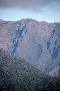
 The colourful east face of Pared de Roberto The colourful east face of Pared de Roberto |
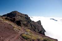
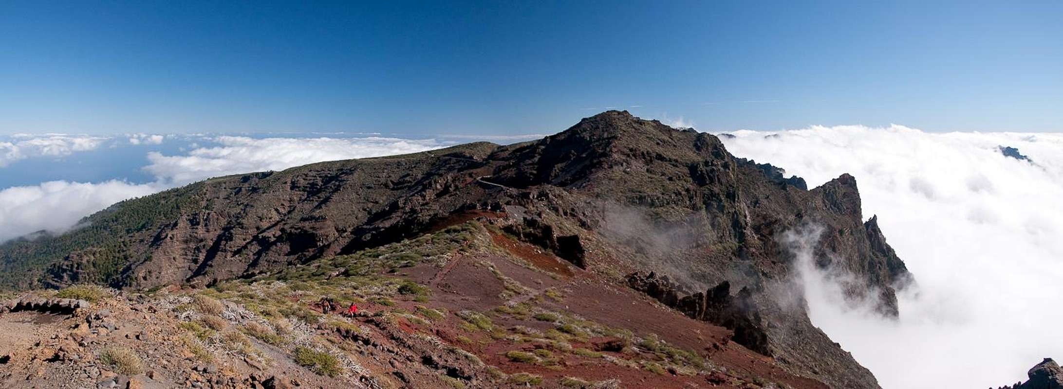
Pared de Roberto - Bob's wall - a strange name for a strange but spectacular mountain. At 2349m it is one of the highest summits on the rim of Caldera de Taburiente, that giant erosion crater on the island of La Palma on the Islas Canarias. If I counted correctly it comes in at number 5, right after its direct neighbours. Thanks to a road (more on that later) which runs by within 200m of its summit it is one of the most photographed mountains on the island. Caldera de Taburiente is one of the world's largest erosion craters at 9km diameter and 29km circumference. Have a look at the interactive map to see and believe!
But let's start with the name. Roberto - in this case - seems to be a local name for the devil. There is a legend that two young lovers used to meet under a cedar on the Cumbre de los Andenes, as the rim of the Caldera is sometimes called. The devil, being jealous of the luck and happiness pulled up a wall to seperate them. The young man, trying to climb across the wall nearly succeeded but the ground opened and spilled out evil spirits which dragged the young couple together with the cedar under which they used to meet into the abyss.
 |  | 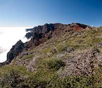 |
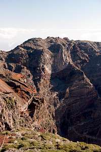
Pared de Roberto - the summit - is criss-crossed by multiple basalt walls, which quite obviously gave rise to its name. Some of the walls lead directly down into the crater in what must be one of its steepest sections. The two saddles to each side of the mountain offer incredible views to the inside of the caldera and serve as the shortest trailheads for the ascent of the mountain. The ascent is rather easy - if you attempt it from the right angle. There is the two day trekking trail Ruta de la Cresteria which follows two thirds of the caldera rim. It runs through the south face of Pared de Roberto, sometimes dangling above the inside of the crater quite precariously. You need to leave this trail immediately west of the summit to scramble to its top. From all other directions the steepness and horrible rock quality prevent the ascent.
 |  |
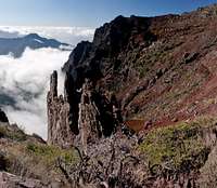
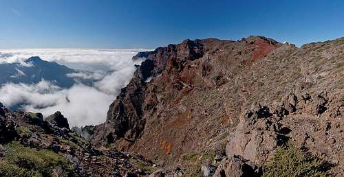
Besides the basalt walls the real show about Pared de Roberto is its colour - or rather the colour of its surrounding slopes. To be honest, the whole caldera rim is a wonderful show of colours but here it finds its culmination in a deep red, which covers the eastern slopes. Together with the often deep blue sky and abundant greenery you can barely ask for more. Throw in some low hanging clouds inside the caldera and you get an unforgettable mixture.
 |  |  |  |
Back to the aforementioned road: Roque de los Muchachos and Pico de la Fuente Nueva, the two western neighbours of Pared de Roberto, are home to a dozen telescopes. Thanks to the clear air and usually dry night conditions, the two mountains are the best locations on European ground for astronomy. To serve the telescopes a road was built which in fact ends on top of La Palma's highpoint, Roque de los Muchachos. Therefore any of the mountains on Caldera de Taburiente's rim has become easily accessible and Pared de Roberto easiest of all. The road runs through the saddle to its east, Degollada de Franceses, where at any time of the day you will find tourist cars parked underneath the rockfall-prone walls. Most tourists don't leave the road and the summit is as lonesome as it can get under these conditions.
Panoramic View
  |
Getting There
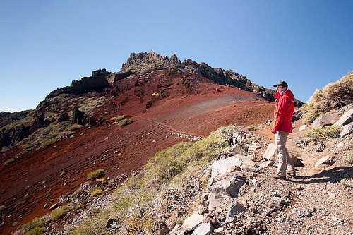 Hiking the east face of Pared de Roberto
La Palma, like all the other Canarian Islands can easily be reached from almost all major European airports. The airport is rather small and compared to Tenerife or Gran Canaria air trafic is rather low. Only Iberia has regular flights but all year round you'll be able to book charter flights. The airport itself is located on the eastern coast of the island, almost at its centre.
There are several trailheads which can be used to climb the mountain. All lie on LP-4, the high mountain road which connects Santa Cruz de La Palma with Garafia and which serves to support the astronomical observatories on top of the caldera. Pared de Roberto is located directly above the road and the shortest access is from Degollada de Franceses to its east. Other trailheads are at Pico de la Nieve 9km to the south, Pico de la Cruz, 2km to the south-east and Roque de los Muchachos, 4km to the west.
- Follow LP-1 from the airport through the capital of Santa Cruz.
- After the city, at El Morro, LP-4 turns off to the left (west). There are signs for the observatories at Roque de los Muchachos.
- Follow the winding road towards Pico de la Nieve or Roque de los Muchachos.
Red Tape
 Pared de Roberto in front of Roque de los Muchachos
The summit of Pared de Roberto is part of the Parque Nacional de la Caldera de Taburiente. This means on the inside of the park boundary you are not allowed to leave the trails or to camp in the vicinity of the summit. Depending on the weather, leaving the trails can be rather dangerous. The caldera is composed of rather loose rocks and in wet or stormy conditions many a rock fall will occur.
Accommodation
Accommodation is not much of a problem. Though there are no campgrounds on the island, hotel rooms and apartments (or number of beds) exceed the actual number of travellers by a ratio of 3:1. Every European travel office will be able to book hotel rooms and apartments for you. Or you can simply use google to find good offers. Often rural fincas can be much less expensive than the regular tourist offers though quality might be more of a problem.Weather Conditions
Usually all year round the Canarias have the same weather with little alterations: north-eastern trade winds which deposit fog and dew on the north-eastern slopes of the islands. The eastern and southern parts usually are very dry and there you'll get some hours of sunshine each day. Especially on the higher islands like La Palma you usually don't have to worry about weather too much. The mountaintops will stick out of the clouds.
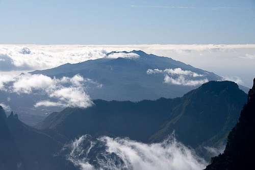 Cumbre Vieja seen from Pared de Roberto
Now here's the problem: We spent two vacations on La Palma in late February 2005 and late December 2009. Both times we had fierce western winds which were loaded with moisture. We had torrential rain for hours on end and several times couldn't even drive by car because the roads were flooded. In these conditions anything can happen in the mountains!
There are no reliable weather forecasts for the mountain regions of La Palma. Often a cloudless day turns into a foggy one within half an hour. Forecasts for the coastal regions, however are available. You have to subtract 0.7°C for every 100m of altitude so that Roque de los Muchachos will still be near freezing when the coasts have already fine and sunny beach weather. The following table gives a little overview about the average weather data of the capital of Santa Cruz:
| Month | Jan | Feb | Mar | Apr | May | Jun | Jul | Aug | Sep | Oct | Nov | Dec |
| Avg. day temp.[°C / °F] | 21 / 70 | 21 / 70 | 22 / 72 | 22 / 72 | 22 / 72 | 24 / 75 | 25 / 77 | 26 / 79 | 26 / 79 | 26 / 79 | 24 / 75 | 22 / 72 |
| Avg. night temp.[°C / °F] | 15 / 59 | 14 / 57 | 15 / 59 | 16 / 61 | 17 / 63 | 18 / 64 | 19 / 66 | 21 / 70 | 21 / 70 | 19 / 66 | 18 / 64 | 16 / 61 |
| Water temp.[°C / °F] | 19 / 66 | 18 / 64 | 19 / 66 | 19 / 66 | 19 / 66 | 20 / 68 | 22 / 72 | 23 / 73 | 22 / 72 | 22 / 72 | 21 / 70 | 20 / 68 |
| Sunny Hours / Day | 5 | 6 | 6 | 7 | 8 | 9 | 10 | 9 | 8 | 6 | 5 | 5 |
Maps & Books
I have used a fantastic map by Freytag & Berndt which shows all of the many hiking and biking trails of the island. With its scale of 1:30000 it is still large enough to be usefu for car tours as well. Moreover here you will find all the new designations and acronyms (which were changed some few years back).
- La Palma
1:30000
Edition Freytag & Berndt
ISBN: 3-7079-0346-X
The guidebook I used is every bit as good as the map with excellent tour descriptions. It is available in English as well but I am not sure about the quality of the translation.
- La Palma
A. and W. Wolfsperger
Rother Verlag
ISBN:
978-3-7633-4246-4 (German)
978-3-7633-4808-4 (English)