
-
 4973 Hits
-
 78.27% Score
-
 9 Votes
|
|
Mountain/Rock |
|---|---|
|
|
28.74509°N / 17.89553°W |
|
|
Hiking |
|
|
Spring, Summer, Fall, Winter |
|
|
7566 ft / 2306 m |
|
|
Overview
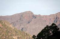
 Roque Palmero and Roque Chico from Espigoon del Roque Roque Palmero and Roque Chico from Espigoon del Roque |
Roque Palmero is the eighth highest mountain of the island of La Palma among the Canary Islands. It is located on the rim of Caldera de Taburiente, one of the world's tallest and widest erosion craters. Like its neighbours, Roque Palmero is easy to get to from the outside. A road LP-4, leads to the top of Roque de los Muchachos, the island's highpoint. From there a panoramic hiking trail leads to Roque Palmero and beyond.
 |  |  |
The mountain is located to the north-west of the crater and has one of the most impressive faces on all the Islas Canarias. The south face virtually drops for 1500m until it reaches the bottom of Caldera de Taburiente. However, rock quality is horrible so that climbing that face is no option. Roque Palmero is set several steps aside from La Palma's trekking route, the Ruta de la Cresteria, which circles the caldera along its rim from the El Time face in the far west to Punta de los Roques in the south. On fine days it commands absolutely stunning views into the caldera but fine days are rare on the crater rim. Very often trade wind clouds hover around the summits in the afternoon, obscuring views.
 |  | |
In comparison with most of the other mountains on the Caldera de Taburiente rim, Roque Palmero is rarely visited. Apart from the trekkkers, who also often pass by, only occasional hikers walk the path from Roque de los Muchachos. Most hiking traffic is reserved for the mountains in the north-east of the rim, where the mountain roas LP-4 almost touches the edge. Also, there the summits are higher, making for more interesting destinations. Roque Palmero is located directly opposite of the Cumbrecita Saddle, the large gap, which divides Pico Bejenado from the remainder of the caldera. Thus, quite often the mountain makes an appearance on pictures taken from or of the saddle.
Getting There
 The western Caldera de Taburiente
La Palma, like all the other Canarian Islands can easily be reached from almost all major European airports. The airport is rather small and compared to Tenerife or Gran Canaria air trafic is rather low. Only Iberia has regular flights but all year round you'll be able to book charter flights. The airport itself is located on the eastern coast of the island, almost at its centre.
There is one trailhead which can be used to climb the mountain. It lies on LP-4, the high mountain road which connects Santa Cruz de La Palma with Garafia and which serves to support the astronomical observatories on top of the caldera. Roque Palmero is located west of Roque de los Muchachos where you can find a small parking lot.
- Follow LP-1 from the airport through the capital of Santa Cruz.
- After the city, at El Morro, LP-4 turns off to the left (west). There are signs for the observatories at Roque de los Muchachos.
- Follow the winding road towards Roque de los Muchachos.
Red Tape
 Roque Palmero
The summit of Roque Palmero is part of the Parque Nacional de la Caldera de Taburiente. This means on the inside of the park boundary you are not allowed to leave the trails or to camp in the vicinity of the summit. Depending on the weather, leaving the trails can be rather dangerous. The caldera is composed of rather loose rocks and in wet or stormy conditions many a rock fall will occur.
Accommodation
Accommodation is not much of a problem. Though there are no campgrounds on the island, hotel rooms and apartments (or number of beds) exceed the actual number of travellers by a ratio of 3:1. Every European travel office will be able to book hotel rooms and apartments for you. Or you can simply use google to find good offers. Often rural fincas can be much less expensive than the regular tourist offers though quality might be more of a problem.Weather Conditions
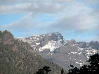
 Roque Palmero seen through the typical Caldera Fog
Usually all year round the Canarias have the same weather with little alterations: north-eastern trade winds which deposit fog and dew on the north-eastern slopes of the islands. The eastern and southern parts usually are very dry and there you'll get some hours of sunshine each day. Especially on the higher islands like La Palma you usually don't have to worry about weather too much. The mountaintops will stick out of the clouds.
Now here's the problem: We spent two vacations on La Palma in late February 2005 and late December 2009. Both times we had fierce western winds which were loaded with moisture. We had torrential rain for hours on end and several times couldn't even drive by car because the roads were flooded. In these conditions anything can happen in the mountains!
There are no reliable weather forecasts for the mountain regions of La Palma. Often a cloudless day turns into a foggy one within half an hour. Forecasts for the coastal regions, however are available. You have to subtract 0.7°C for every 100m of altitude so that Roque de los Muchachos will still be near freezing when the coasts have already fine and sunny beach weather. The following table gives a little overview about the average weather data of the capital of Santa Cruz:
| Month | Jan | Feb | Mar | Apr | May | Jun | Jul | Aug | Sep | Oct | Nov | Dec |
| Avg. day temp.[°C / °F] | 21 / 70 | 21 / 70 | 22 / 72 | 22 / 72 | 22 / 72 | 24 / 75 | 25 / 77 | 26 / 79 | 26 / 79 | 26 / 79 | 24 / 75 | 22 / 72 |
| Avg. night temp.[°C / °F] | 15 / 59 | 14 / 57 | 15 / 59 | 16 / 61 | 17 / 63 | 18 / 64 | 19 / 66 | 21 / 70 | 21 / 70 | 19 / 66 | 18 / 64 | 16 / 61 |
| Water temp.[°C / °F] | 19 / 66 | 18 / 64 | 19 / 66 | 19 / 66 | 19 / 66 | 20 / 68 | 22 / 72 | 23 / 73 | 22 / 72 | 22 / 72 | 21 / 70 | 20 / 68 |
| Sunny Hours / Day | 5 | 6 | 6 | 7 | 8 | 9 | 10 | 9 | 8 | 6 | 5 | 5 |
Maps & Books
I have used a fantastic map by Freytag & Berndt which shows all of the many hiking and biking trails of the island. With its scale of 1:30000 it is still large enough to be usefu for car tours as well. Moreover here you will find all the new designations and acronyms (which were changed some few years back).
- La Palma
1:30000
Edition Freytag & Berndt
ISBN: 3-7079-0346-X
The guidebook I used is every bit as good as the map with excellent tour descriptions. It is available in English as well but I am not sure about the quality of the translation.
- La Palma
A. and W. Wolfsperger
Rother Verlag
ISBN:
978-3-7633-4246-4 (German)
978-3-7633-4808-4 (English)