
-
 20126 Hits
-
 91.14% Score
-
 34 Votes
|
|
Area/Range |
|---|---|
|
|
28.73000°N / 17.87°W |
|
|
7960 ft / 2426 m |
|
|
Overview
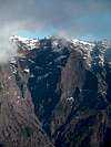
Caldera de Taburiente with its external slopes takes up the complete northern half of the island of La Palma (Islas Canarias). It is, simply said, the largest erosion crater on this planet. Just figure the following statistics:- Circumference: 29km (14miles)
- Diameter: 9km (5miles)
- Average height of the caldera wall: 2000m (6000ft)
- Highest summit: Roque de los Muchachos: 2426m (7959ft)
- Outside elevation: 0m (0ft)
- Inside elevation: 700m (2100ft)
All this results in one of the truly most impressive mountain ranges you can find. All the highest mountains of La Palma are located on the crest of the crater, easy to access from the outside but impossible to get at from inside the caldera. Here you can find vertical walls of up to 1500m height, notably the ones to the north-east of the crater. The Caldera is open on its southwestern side, where Rio de Taburiente, the only river on the Canarias, has carved out a deep gorge (Barranco de las Angustias) towards the sea. This gorge in itself is worth seeing since even here you can find those 100m walls.
Caldera de Taburiente is the leftover of a giant volcanic mountain range rather than a single volcano. It consists of rather lose material (no climbing through the walls) which is in a permanent state of erosion. When we visited Piedra Llana on the crater rim we could hear a huge landslide on the inside of the caldera when several tons of rock toppled into the crater. Today's form of the caldera was created 550.000 years ago when huge chunks of the mountain range slid into the sea to the western side of the island. Ever since wind and rain have sculpted the rocks to leave truly impressive towers.
Since climbing is no option around Caldera de Taburiente it is a veritable hiking paradise. There are two access possibilities for the inside of the crater, one along Barranco de las Angustias, to the southwest, on from the Cumbrecita saddle, which is located almost directly to the south of the caldera, in a place where the rim suddenly drops from 2000m to 1500m. Moreover there is a beautiful two day trekking trail along the rim of the caldera, the "Ruta de la Cresteria", which starts at sea level and does a 270° circle of the crater before ending at Reventon Pass, where the Cumbre Nueva Mountain Range starts. It can be combined with the equally beautiful (but completely different) "Ruta de los Volcanes" along the crest of the Cumbre Vieja Mountain Range in the south of the island. This would result in a three or four day treck without any real shelters. Consequently it should only be done in perfect weather conditions.
Oh yes, the weather: usually you can expect clear skies in the mornings. Depending on the amount of humidity still in the air and on the ground over the day clouds build up on the inside of the crater (starting in the north-west). These clouds usually hover around the caldera crest only occasionally leaving enough room to look into the crater itself. On humid days the whole caldera will shroud itself in clouds while on arid days the eastern part will be left free of fog. In this case, in the evening you'll have perfect skies again.
 |  |  |  |  |
Panoramic View
Roque Palmero Roque ChicoRoque de los MuchachosPico de la Fuente NuevaPico del AtaúdPico de la CruzPiedra LlanaPico de la NieveRoque de la FortalezzaRoque del Huso Roque de la Brovera MachaRoque Salvaje
 |  |  |
Panoramic shot of the Caldera de Taburiente. Hide / Show Annotations
Mountains on the Crest
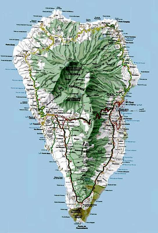
As said above, the caldera crest is home to the highest mountains of La Palma. Many of them can easily be reached by a road which serves the (multiple) astrophysical observatories near Roque de los Muchachos. The highest summits are located to the northern and eastern sides of the caldera and all reach elevations of more than 2200m. The "Ruta de la Cresteria" does not lead across the summits so a little side stepping is always necessary. Starting from Puerto Tazarcorte you will see the following summits:- Hoya Grande (1297m)
- Risco de la Pareditas (1699m)
- Sommada Alta (1927m)
- Roque Palmero (2306m)
- Roque Chico (2368m)
- Roque de los Muchachos (2426m)
- Cruz del Fraile (2325m)
- Pico de la Fuente Nueva (2375m)
- Pared de Roberto (2349m)
- Pico de la Cruz (2351m)
- Piedra Llana (2314m)
- Pico de la Cruz (2252m)
- Pico de la Nieve (2232m)
- Pico de la Sabina (2137m)
- Pico de la Veta de la Arena (2118m)
- Pico del Cedro (1943m)
- Piedras del Catre (2017m)
- Punta de los Roques (2085m)
- Pico Bejenado (1844m)
- Picachos Andén (1384m)
 |  |  |
Getting There
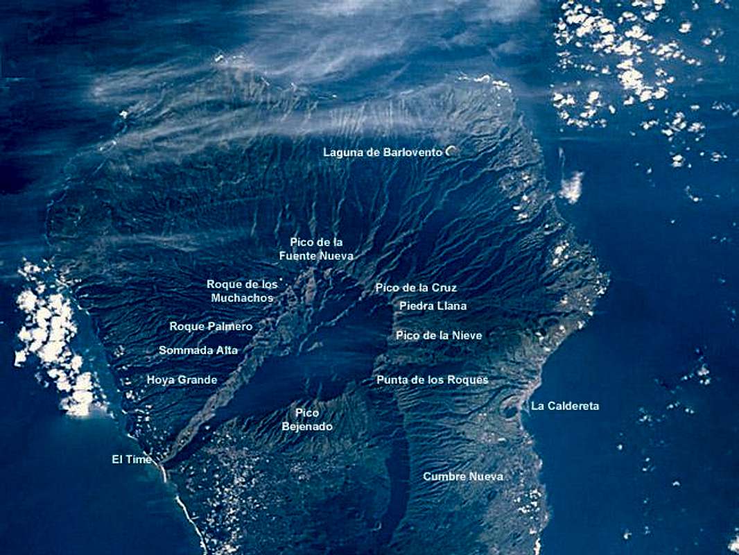
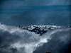
Photo credit: Image Science and Analysis Laboratory, NASA-Johnson Space Center. 2 Nov. 2004. "Astronaut Photography of Earth - Quick View." (6 Apr. 2005).
La Palma, like all the other Canarian Islands can easily be reached from almost all major European airports. The airport is rather small and compared to Tenerife or Gran Canaria air trafic is rather low. There are almost no regular flights but all year round you'll be able to book charter flights.
Inside the Caldera
There are two trailheads for the inside of the crater:
- Barranco de los Angustias
This trailhead is at the south-western end of the caldera. There are two ways to reach the inside from here - through the gorge or via a trail, which leads along to the west of it. In wet conditions (winter spring) Rio de Taburiente carries too much water for the gorge to be accessible.
You reach the parking lot at Barranco de las Angustias by travelling LP-1 north from the airport. After a short while LP-2 turns off westwards and crosses the Cumbre Nueva Ridge through a large tunnel. Take LP-2 towards Los Llanos, where you need to turn north-east into the Caldera. There are signs for Caldera de Taburiente.
- Mirador de la Cumbrecita
Between Punta de los Roques and Pico Bejenado there is a deep cut in the caldera wall, where the Cumbrecita Saddle is located. This is a touristy spot with a short and easy loop trail where hundreds of tourons will be found. From here a trail (PR LP 13.1) leads into the crater below the walls of Pico de la Nieve and Piedra Llana. This trail can only be hiked in secure weather conditions because it is prone to heavy and serious landslides. During our stay it was closed.
To reach Cumbrecita, again follow LP-1 and LP-2 (see above) through the Cumbre Nueva Tunnel. Shortly after the tunnel LP-202 turn off to the right (north) - there is the Caldera de Taburiente Information Centre at the intersection. Follow this road, it will lead you to the Cumbrecita Saddle. But: be prepared to have to park your car far from Cumbrecita since the parking lots are very small.
Caldera Crest
The crest of Caldera de Taburiente is most easily reached by the mountain road LP-22. If you want to start the Ruta de la Cresteria from sea level you have to go to Puerto Tarzacorte instead. The other entry point for the Ruta is Reventon Pass which you will most easily reach from the little Chapel Ermita de la Virgen del Pino.
- Mountain Road LP-22
Follow LP-1 from the airport through the capital of Santa Cruz. After the city at El Morro LP-22 turns off to the left (west). There are signs for the observatories at Roque de los Muchachos. Follow the winding road towards Pico de la Nieve, Pico de la Cruz or Roque de los Muchachos.
- Puerto Tazarcorte
Follow LP-1 and LP-2 through the Cumbre Nueva Tunnel in direction of Los Llanos. After Los Llanos head for Tazarcorte (LP-122), where you turn right (north) to Puerto Tazarcorte. The climb begins directly at the beachfront and follows a beautiful Camino Real throgh the wall of El Time.
- Ermita de la Virgen del Pino
Again follow LP-1 and LP-2 through the Cumbre Nueva Tunnel. At the Visitor Centre turn onto LP-202 like you would go to Cumbrecita (see above). After about 1km turn to the right (east). There are already signs for the Ermita which is at the end of the road.
Red Tape
Caldera de Taburiente is part of Parque Nacional Caldera de Taburiente, which was created in 1954 and which consists of an area of 4690ha. On the inside of the crater the folowing restrictions apply:- stay on the marked trails - several parts of the caldera are off-limits alltogether
- no camping within the caldera. There is a campground at Playa de Taburiente which you can use if you have obtained a permit beforehand. Only one day stays are permitted.
 |  |  |  |  |
When To Climb
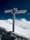
The caldera can be climbed/hiked all year round. In winter and spring you might encounter heavy rains which means landslides and a flooded Barranco de las Angustias. On the rim you often find snow and - believe it or not - crampons might be required, especially when the snow gets rained upon and ice layers form.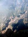 |  |  | 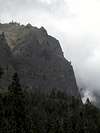 |
Accommodation
Camping is a bit of a problem on La Palma. There are some official campgrounds in the north but the one near Los Canarios is still a project. There are, however, a couple of "Zonas Recreativas" where sometimes you are allowed to pitch a tent. For the caldera this would be at Playa de Taburiente for which you have to obtain a one day permit beforehand. It can be obtained at the visitor's center at the intersection of LP-2 and LP-202 (sse Getting there for the Cumbrecita Trailhead).Other accommodations are no problem. Every European travel office will be able to book hotels, rooms and apartments for you. I won't include any links here because all of them definitely are commercial. Another option is to rent a finca (rural house) from the owners directly. You'll have to google for these but sometimes prices are low enough for the scheme to be worthwhile.
 |  |  |
Weather Conditions
I'm a bit at a loss here. Usually all year round the Canarias have the same weather with litlle alterations: north-eastern trade winds which deposit fog and dew on the north-eastern slopes of the islands. The eastern and southern parts usually are very dry and there you'll get some hours of sunshine each day. Especially on the higher islands like La Palma you usually don't have to worry about weather too much. The mountaintops will stick out of the clouds.Now here's my problem: when we were on our vacation to La Palma in late Febuary 2005 we had a week of fierce western winds which were loaded with moisture. We had veritable downpours for ours on end and several times couldn't even drive by car because the roads were flooded. I'm quite sure that this was a freak phenomenon. The western side of La Palma usually gets 28cm (19 inches) of rain per year!
There are no reliable weather forecasts for the mountain regions of La Palma. Often a cloudless day turns into a foggy one within half an hour. Especially the Cumbre Vieja Range is prone to these fogs and here orientation among the lava and scree fields gets very difficult. This is the main reason why you should never leave the trails there.
Forecasts for the coastal regions, however are available. You have to subtract 1°C for every 100m of altitude so that Roque de los Muchachos will still be near freezing when the coasts have already fine and sunny beach weather. The following table gives a little overview about the average weather data of the capital of Santa Cruz:
| Month | Jan | Feb | Mar | Apr | May | Jun | Jul | Aug | Sep | Oct | Nov | Dec |
| Avg. day temp.[°C / °F] | 21 / 70 | 21 / 70 | 22 / 72 | 22 / 72 | 22 / 72 | 24 / 75 | 25 / 77 | 26 / 79 | 26 / 79 | 26 / 79 | 24 / 75 | 22 / 72 |
| Avg. night temp.[°C / °F] | 15 / 59 | 14 / 57 | 15 / 59 | 16 / 61 | 17 / 63 | 18 / 64 | 19 / 66 | 21 / 70 | 21 / 70 | 19 / 66 | 18 / 64 | 16 / 61 |
| Water temp.[°C / °F] | 19 / 66 | 18 / 64 | 19 / 66 | 19 / 66 | 19 / 66 | 20 / 68 | 22 / 72 | 23 / 73 | 22 / 72 | 22 / 72 | 21 / 70 | 20 / 68 |
| Sunny Hours / Day | 5 | 6 | 6 | 7 | 8 | 9 | 10 | 9 | 8 | 6 | 5 | 5 |
 |  |  |  |  |
Maps 'n' Books
Please excuse me if I only post German maps and books. I know there are editions in all European languages but I'm not aware of them. Any help is very welcome!I have used a fantastic map by Freytag & Berndt which shows all of the many hiking and biking trails of the island. With its scale of 1:30000 it is still large enough to be usefu for car tours as well. Moreover here you will find all the new designations and acronyms (which were changed some few years back).
- La Palma
1:30000
Edition Freytag & Berndt
ISBN: 3-7079-0346-X
The guidebook I used is every bit as good as the map with excellent tour descriptions. It is available in English as well but I am not sure about the quality of the translation.
- La Palma
A. and W. Wolfsperger
Rother Verlag
ISBN:
3-7633-4246-X (German)
3-7633-4808-5 (English)
 |  |  |
rgg - Nov 25, 2010 7:14 pm - Voted 10/10
External linksHow about this one? Parque Nacional de la Caldera de Taburiente