
-
 9888 Hits
-
 84.82% Score
-
 19 Votes
|
|
Mountain/Rock |
|---|---|
|
|
28.75442°N / 17.85343°W |
|
|
Hiking |
|
|
Spring, Summer, Fall, Winter |
|
|
7713 ft / 2351 m |
|
|
Overview
 Pico de la Cruz from the north Pico de la Cruz from the north |
Of the many summits on the crest of Caldera de Taburiente, there are some, which appear to be more important than others. Roque de los Muchachos, the highest mountain on La Palma, naturally takes the first place in any listing. Roque Palmero in the west of the caldera and Pico de la Nieve in the south come to mind as cornerstones. All these mountains have one thing in common: their summit blocks are big and they stand out from the caldera and its crest. And among these mountains, Pico de la Cruz takes a special place.
Here we are talking about a mountain with three summits, the central one of which reaches 2351m and thus is the third highest summit on the island. It is located in a place on the crest, basically the north-eastern end, where it is visible from all the important lookout spots on La Palma. From the opening of Caldera de Taburiente, from Puerto de Tazarcorte on the western coast, you can look through the narrow Barranco de Angustias and what do you see? Pico de la Cruz. You go to Ermita Virgen del Pino or the Cumbrecita saddle and what is right opposite? Pico de la Cruz. As you climb the long Cumbre Nueva Ridge towards Punta de los Roques, what hovers right above the Punta? You guessed it, Pico de la Cruz.
 |  |  |  |
For the trekkers, who hike Ruta de la Cresteria, sometimes together with Ruta de los Volcanes, Pico de la Cruz is an important landmark: here, in the nooks and crevices around the basalt summit block you can pitch a tent and shiver through the cold Palmeran mountain night during the multiday treck.
Pico de la Cruz, however,, is also popular among the hikers and regular tourists on the island. Its summit is located a 15 minute hike from two parking lots on LP-4, La Palma's mountain road, which runs from Santa Cruz de La Palma to San Domingo de Garafia in the north-west of the island. Every guidebook will recommend the drive and during mid-day you can witness small traffic jams near Degollada de Franceses, 2km to the north-west of the mountain, where the tourists, in order to snap a shot are known to park their car in the middle of the road.
 |  |  |
Pico de la Cruz is set aside from this place and there are two parking spaces on either side of the summit. Anyone who wants to see a bit more than just one glimpse down into the Caldera will park there and try to reach the summit. The southern approach is more difficult as it involves block scrambling across the basalt blocks which make up the summit. The northern approach, however is easy and well beaten by the many boots which walk it every day. On top of Pico de la Cruz you find a small cabin, erected as a meterological station. It is closed and thus not much use for the trekkers which intend to stay overnight.
Pico de la Cruz is a stormy peak. Usually north-eastern trade winds push the clouds across the crest through the saddles to both sides but sometimes, when western winds prevail, the air is channelled into the Caldera, where it rises and gets rid of its humidity by heavy rains. As Pico de la Cruz stands in its way it gets the most of this precipitation. However, weather is a local affair on all the Canary Islands and you can witness wonderful days on the summits nearby even though Pico de la Cruz is hidden in clouds. Usually, however, when evening falls the clouds retreat to reveal cold and starry nights.
(Close to the) summit panorama
Somehow I didn't manage to get a real summit panorama. 360° were out of the question, thanks to the meterological station on the very top. Moreover, clouds spilled over the caldera rim, so that the only reasonable panoramas I have are from some 20 - 30m beneath the summit block.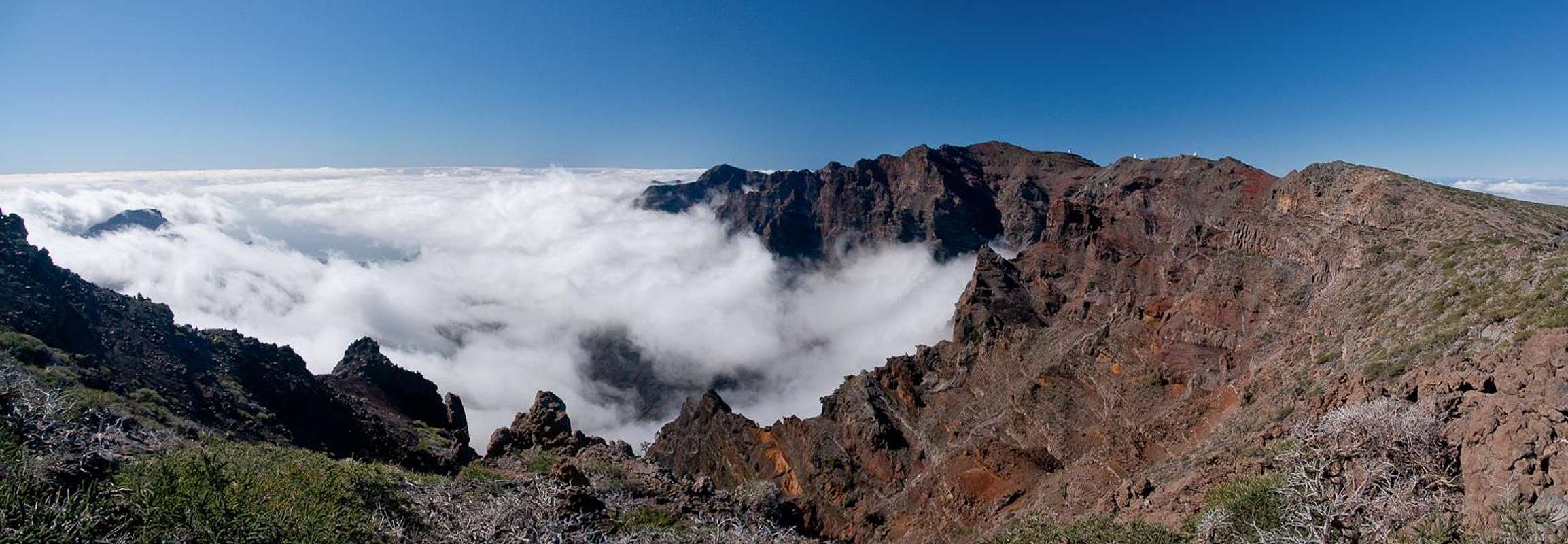  |
Getting There
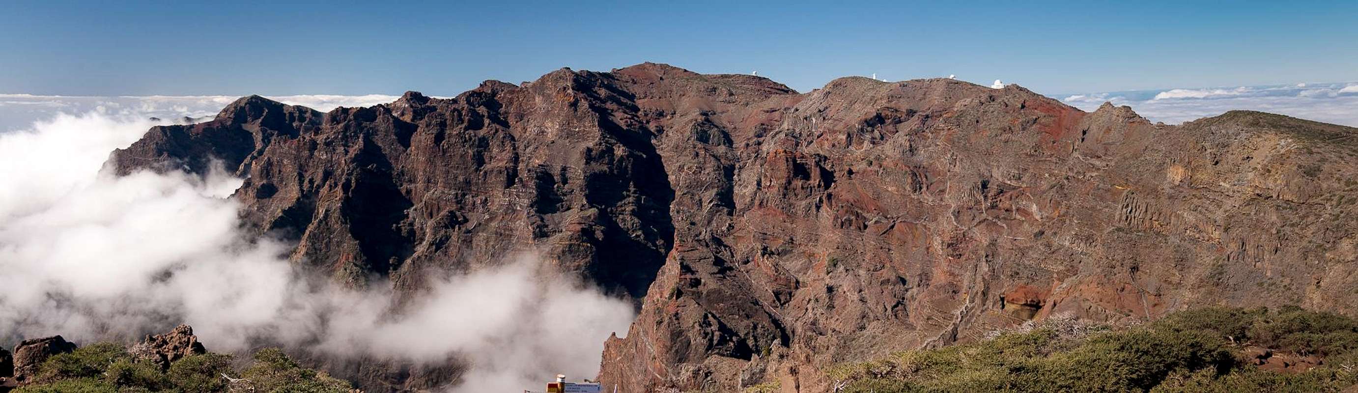
 Pico de la Cruz from Pico de la Fuente Nueva
La Palma, like all the other Canarian Islands can easily be reached from almost all major European airports. The airport is rather small and compared to Tenerife or Gran Canaria air trafic is rather low. Only Iberia has regular flights but all year round you'll be able to book charter flights. The airport itself is located on the eastern coast of the island, almost at its centre.
There are several trailheads which can be used to climb the mountain. All lie on LP-4, the high mountain road which connects Santa Cruz de La Palma with Garafia and which serves to support the astronomical observatories on top of the caldera. Pico de la Cruz is located directly above the road and the shortest access is from small parking lots to either side of it. More interesting trailheads are at Pico de la Nieve 5km to the southand Roque de los Muchachos, 5km to the west.
- Follow LP-1 from the airport through the capital of Santa Cruz.
- After the city, at El Morro, LP-4 turns off to the left (west). There are signs for the observatories at Roque de los Muchachos.
- Follow the winding road towards Pico de la Nieve, Pico de la Cruz or Roque de los Muchachos.
Red Tape
The summit of Pic de la Cruz is part of the Parque Nacional de la Caldera de Taburiente. This means on the inside of the park boundary you are not allowed to leave the trails or to camp in the vicinity of the summit. Depending on the weather, leaving the trails can be rather dangerous. The caldera is composed of rather loose rocks and in wet or stormy conditions many a rock fall will occur.Accommodation
 |
Accommodation is not much of a problem. Though there are no campgrounds on the island, hotel rooms and apartments (or number of beds) exceed the actual number of travellers by a ratio of 3:1. Every European travel office will be able to book hotel rooms and apartments for you. Or you can simply use google to find good offers. Often rural fincas can be much less expensive than the regular tourist offers though quality might be more of a problem.
Weather Conditions
Usually all year round the Canarias have the same weather with little alterations: north-eastern trade winds which deposit fog and dew on the north-eastern slopes of the islands. The eastern and southern parts usually are very dry and there you'll get some hours of sunshine each day. Especially on the higher islands like La Palma you usually don't have to worry about weather too much. The mountaintops will stick out of the clouds.
 Punta de los Roques and Pico Bejenado
Now here's the problem: We spent two vacations on La Palma in late February 2005 and late December 2009. Both times we had fierce western winds which were loaded with moisture. We had torrential rain for hours on end and several times couldn't even drive by car because the roads were flooded. In these conditions anything can happen in the mountains!
There are no reliable weather forecasts for the mountain regions of La Palma. Often a cloudless day turns into a foggy one within half an hour. Forecasts for the coastal regions, however are available. You have to subtract 0.7°C for every 100m of altitude so that Roque de los Muchachos will still be near freezing when the coasts have already fine and sunny beach weather. The following table gives a little overview about the average weather data of the capital of Santa Cruz:
| Month | Jan | Feb | Mar | Apr | May | Jun | Jul | Aug | Sep | Oct | Nov | Dec |
| Avg. day temp.[°C / °F] | 21 / 70 | 21 / 70 | 22 / 72 | 22 / 72 | 22 / 72 | 24 / 75 | 25 / 77 | 26 / 79 | 26 / 79 | 26 / 79 | 24 / 75 | 22 / 72 |
| Avg. night temp.[°C / °F] | 15 / 59 | 14 / 57 | 15 / 59 | 16 / 61 | 17 / 63 | 18 / 64 | 19 / 66 | 21 / 70 | 21 / 70 | 19 / 66 | 18 / 64 | 16 / 61 |
| Water temp.[°C / °F] | 19 / 66 | 18 / 64 | 19 / 66 | 19 / 66 | 19 / 66 | 20 / 68 | 22 / 72 | 23 / 73 | 22 / 72 | 22 / 72 | 21 / 70 | 20 / 68 |
| Sunny Hours / Day | 5 | 6 | 6 | 7 | 8 | 9 | 10 | 9 | 8 | 6 | 5 | 5 |
Maps & Books
I have used a fantastic map by Freytag & Berndt which shows all of the many hiking and biking trails of the island. With its scale of 1:30000 it is still large enough to be usefu for car tours as well. Moreover here you will find all the new designations and acronyms (which were changed some few years back).
- La Palma
1:30000
Edition Freytag & Berndt
ISBN: 3-7079-0346-X
The guidebook I used is every bit as good as the map with excellent tour descriptions. It is available in English as well but I am not sure about the quality of the translation.
- La Palma
A. and W. Wolfsperger
Rother Verlag
ISBN:
978-3-7633-4246-4 (German)
978-3-7633-4808-4 (English)