
-
 7057 Hits
-
 85.87% Score
-
 21 Votes
|
|
Mountain/Rock |
|---|---|
|
|
28.74240°N / 17.8366°W |
|
|
Hiking |
|
|
Spring, Summer, Fall, Winter |
|
|
7591 ft / 2314 m |
|
|
Overview
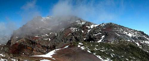 Piedra Llana in one of those tiny clouds which can develop into a rainstorm within seconds Piedra Llana in one of those tiny clouds which can develop into a rainstorm within seconds |
Piedra Llana is one of the most distinctive summits on the crater rim of the Caldera de Taburiente on La Palma. As all rim mountains it is fairly shallow on the outside of the crater but shows impressive drops towards the inside. However, the vertical walls, which drop about 1500m to the caldera bottom cannot be climbed. Apart from the fact that climbing is prohibited in the national park which encompasses the crater, the rock is lose and brittle. It is not rare to witness massive landslides going down like avalanches. In February 2005 we witnessed such a slide when on Piedra Llana (or neighbouring Pico de la Nieve - I forget which) - it was hidden in the low hanging clouds but the thunder rumbled for several minutes.
These landslides tell a lot about the history of the caldera. It is the world's largest erosion crater with 29km circumference and 9km diameter. It still is in a state of erosion the debris of which gets (and got) carried away by the only river of the Islas Canarias - Rio de Taburiente. It collects its waters from short tributaries which come down from each side of the caldera and rushes through the equally impressive Barranco de Angustias to the sea. The length of the river doesn't exceed much more than 10km but it has carved one of the world's most impressive gorges out of the volcanic rock.
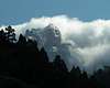
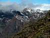
But let's return to the mountain in question: Piedra Llana is the perfectly located lookout peak for over viewing the whole Caldera de Taburiente. It is located opposite to Barranco de Angustias and thus you can see all the way down to the port of Puerto Tazarcorte at its end. Moreover the other lookout summits - Pico Bejenado and Roque de los Muchachos are perfectly visible at the two other sides of the crater circle. Be sure to bring good weather though. In usual circumstances (most of the year) Piedra Llana is way above the clouds. In winter, however you will have to get up real early to get ahead of the fog. If you do you are awarded the best views into the Caldera with colourful gendarmes posing in between.
The mountain is situated very close to La Palma's trekking trail GR131 Ruta de la Cresteria which passes Piedra Llana on the outward side. The park boundary of Parque Nacional de Caldera de Taburiente goes across the summit. All restrictions apply only for the inside of this boundary.
 |
 |
 |
|
 |
Getting There
 Satellite image of the central part of La Palma
Photo credit: Image Science and Analysis Laboratory, NASA-Johnson Space Center. 2 Nov. 2004. "Astronaut Photography of Earth - Quick View." (6 Apr. 2005).
La Palma, like all the other Canarian Islands can easily be reached from almost all major European airports. The airport is rather small and compared to Tenerife or Gran Canaria air trafic is rather low. There are almost no regular flights but all year round you'll be able to book charter flights. The airport itself is located on the eastern coast of the island, almost at its centre.
There are two trailheads, but both are located on LP-22, La Palma's high mountain road which connects the towns of Santa Cruz (the capital) and Santo Domingo via Roque de los Muchachos. The trailheads are near Pico de la Nieve and Pico de la Cruz on both sides of Piedra Llana
Follow LP-1 from the airport through the capital of Santa Cruz. After the city, at El Morro, LP-22 turns off to the left (west). There are signs for the observatories at Roque de los Muchachos. Follow the winding road towards Pico de la Nieve. A rugged side road leads to a parking lot but you can also start directly from LP-22.
If you want to start from Pico de la Cruz follow LP-22 for some further 4km. It almost reaches the summit but parking space is scarce.
 |
 |
 |
 |
 |
Red Tape
 The colourful Morro Negro to the west of Piedra Llana
The summit of Piedra Llana is part of the Parque Nacional de la Caldera de Taburiente. This means on the inside of the park boundary you are not allowed to leave the trails or to camp in the vicinity of the summit. In summer you can sleep under the open sky, however, but this is bound to be very cold at every time of the year. Depending on the weather, leaving the trails can be rather dangerous. The caldera is composed of rather loose rocks and in wet or stormy conditions many a rock fall will occur (see overview).
When To Climb
 The island of eternal spring La Palma is called. Does this look like spring? Juniper on ice
Piedra Llana can be climbed all year. Sometimes (e.g. in Feb 2005) the road to the caldera rim is closed due to snow. In that case it is not advisable to do the hike to the summit. Why? The clouds which love to hver around the caldera summits are very wet. In snowy conditions often ice layers are deposited on top of the snow. Even moderate slopes of 30° get dangerous without the proper equipment.
Accommodation
Camping is a bit of a problem on La Palma. There are some official campgrounds in the north but the one near Los Canarios is still a project. There are, however, a couple of "Zonas Recreativas" where sometimes you are allowed to pitch a tent. On the caldera crest there are no such places, only near Punta de los Roques (south of Pico de la Nieve) you can find a cabin (called rifugio). Most trekkers on Ruta de la Cresteria use the cabin or the space around it to sleep below the open sky.Other accommodations are no problem. Every European travel office will be able to book hotels, rooms and apartments for you. I won't include any links here because all of them definitely are commercial. Another option is to rent a finca (rural house) from the owners directly. You'll have to google for these but sometimes prices are low enough for the scheme to be worthwhile.
Weather Conditions
Usually all year round the Canarias have the same weather with little alterations: north-eastern trade winds which deposit fog and dew on the north-eastern slopes of the islands. The eastern and southern parts usually are very dry and there you'll get some hours of sunshine each day. Especially on the higher islands like La Palma you usually don't have to worry about weather too much. The mountaintops will stick out of the clouds.Now here's the problem: when we were on our vacation to La Palma in late February 2005 we had a week of fierce western winds which were loaded with moisture. We had veritable downpours for hours on end and several times couldn't even drive by car because the roads were flooded. I'm quite sure that this was a freak phenomenon. The western side of La Palma usually gets 28cm (19 inches) of rain per year!
There are no reliable weather forecasts for the mountain regions of La Palma. Often a cloudless day turns into a foggy one within half an hour. Especially the Cumbre Vieja Range is prone to these fogs and here orientation among the lava and scree fields gets very difficult. This is the main reason why you should never leave the trails there.
Forecasts for the coastal regions, however are available. You have to subtract 1°C for every 100m of altitude so that Roque de los Muchachos will still be near freezing when the coasts have already fine and sunny beach weather. The following table gives a little overview about the average weather data of the capital of Santa Cruz:
| Month | Jan | Feb | Mar | Apr | May | Jun | Jul | Aug | Sep | Oct | Nov | Dec |
| Avg. day temp.[°C / °F] | 21 / 70 | 21 / 70 | 22 / 72 | 22 / 72 | 22 / 72 | 24 / 75 | 25 / 77 | 26 / 79 | 26 / 79 | 26 / 79 | 24 / 75 | 22 / 72 |
| Avg. night temp.[°C / °F] | 15 / 59 | 14 / 57 | 15 / 59 | 16 / 61 | 17 / 63 | 18 / 64 | 19 / 66 | 21 / 70 | 21 / 70 | 19 / 66 | 18 / 64 | 16 / 61 |
| Water temp.[°C / °F] | 19 / 66 | 18 / 64 | 19 / 66 | 19 / 66 | 19 / 66 | 20 / 68 | 22 / 72 | 23 / 73 | 22 / 72 | 22 / 72 | 21 / 70 | 20 / 68 |
| Sunny Hours / Day | 5 | 6 | 6 | 7 | 8 | 9 | 10 | 9 | 8 | 6 | 5 | 5 |
Maps 'n' Books
Please excuse me if I only post German maps and books. I know there are editions in all European languages but I'm not aware of them. Any help is very welcome!I have used a fantastic map by Freytag & Berndt which shows all of the many hiking and biking trails of the island. With its scale of 1:30000 it is still large enough to be usefu for car tours as well. Moreover here you will find all the new designations and acronyms (which were changed some few years back).
- La Palma
1:30000
Edition Freytag & Berndt
ISBN: 3-7079-0346-X
The guidebook I used is every bit as good as the map with excellent tour descriptions. It is available in English as well but I am not sure about the quality of the translation.
- La Palma
A. and W. Wolfsperger
Rother Verlag
ISBN:
3-7633-4246-X (German)
3-7633-4808-5 (English)