Overview
NOTE: This page was originally written by Colonelpyat
Prominence: 850 feet
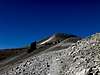
At 14,036' Mount Sherman is the 45th highest peak in Colorado. Situated in the Mosquito Range, it lies roughly midway between the cities of Fairplay and Leadville. Although visible from both sides of this north-south running range, Mount Sherman is not easily identified. Gentle ridges run both directions from its broad summit to peaks nearly as high, making it easy to mistake Sherman for one of its neighbors.
While the gentle nature of Sherman makes it hard to identify, it also makes it a relatively easy peak to climb. Over the years it has developed a reputation for being one of the easiest 14ers to climb. As such, it is a very popular first 14er for those who wish to take their hiking to new heights. On just about any given weekend during the summer one can expect to be in the company of those treading higher than they ever have before.
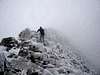
Mount Sherman is usually climbed by one of two routes. Both have their attractions. The most common approach is from the east, via Fairplay and Fourmile Creek. This route wanders up a jeep road, passing by the ruins of some interesting old mines as it gains elevation. The other is from the west, via Leadville and Iowa Gulch. An easy stroll across an alpine meadow starts this journey and leads to the steeper terrain ahead. Both routes come together on Sherman's narrow south ridge and follow a good trail for one mile to its large summit. Hikers can continue on from there to other peaks in the area. To the north are Gemini Peak and Dyer Mountain. To the south is Mount Sheridan.
Getting There
Fourmile Creek:
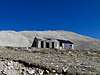
Drive one mile south from from the intersection of US 285 and Colorado 9 in Fairplay. Turn west on Park County 18 (dirt) and drive 10.5 miles to the old Leavick townsite at 11,240 feet. Most hikers choose to park here. Those wishing to shorten the hike can drive further up the road. Most passenger cars can go 1.5 miles further to a closure gate at 12,000' below the Dauntless Mine.
Iowa Gulch:
Drive to the E. Third Street junction with US 24 in downtown Leadville. Go east on Third street for 0.3 miles to S. Toledo Street. Turn right (south) and drive Lake County 2. Stay north (left) after 4 miles on a dirt road that passes north of the ASARCO Mine. Continue east on Iowa Gulch's north side. Park after 6.4 miles at 11,900 feet.
Red Tape
No permit is required to climb Mt. Sherman. Be aware that approaches from all sides of Sherman cross private property. Please respect the rights of the landowners and help guarantee access for others to follow
When To Climb
Mt. Sherman is climbed year-round, but optimal conditions generally occur from late June through September. Be aware that this also the season for afternoon thunderstorms in the Colorado mountains. Hikers should plan to be on the way down by noon.
Camping
Click here for information on established campgrounds in the South Park Ranger District. The Fourmile and Horseshoe campgrounds are convenient to the Fourmile Creek trailhead. The campgrounds at Turquoise Lake, four miles west of Leadville, appear to be the most convenient to the Iowa Gulch trailhead.
Mountain Conditions
Click here for the latest forecast from the National Weather Service.
Click here for the latest report from the Colorado Avalanche Information Center.
External Links

 117813 Hits
 91.45% Score
 35 Votes