
-
 13527 Hits
-
 90.48% Score
-
 32 Votes
|
|
Mountain/Rock |
|---|---|
|
|
40.88000°N / 112.8198°W |
|
|
Tooele |
|
|
Hiking |
|
|
Spring, Summer, Fall, Winter |
|
|
6625 ft / 2019 m |
|
|
Overview
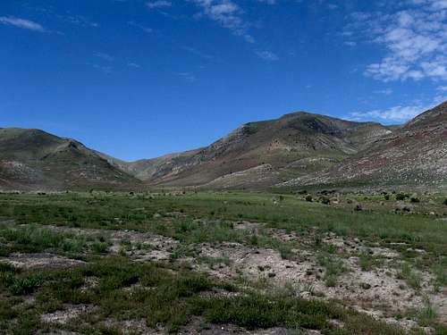
Another of the Utah top 100 prominence peaks coming in at #83 on the list, this one just barely misses being a 2000 foot prominence peak by just a few feet. Craner Peak is the highpoint of the Lakeside mountain range and is another of those peaks that Utahan's on the way to Wendover see coming and going but never know the name of the range and the peaks they are looking at. Who can blame them for not knowing? Utah has so many ranges that it would be hard to know what you are looking at so hopefully, this page will begin to open the eyes of understanding a bit and add knowledge about the wonderful treasures that are lurking out in the west Utah desert area. Craner Peak is another of those Utah gems, a worthy hike when snow blankets the Wasatch.The largest magnesium plant in the USA sits just east of Craner Peak at Rowley Utah and is easy to notice as it has a continuous plume of "smoke"heading skyward. MagCorp manages this plant which provides over 400 jobs to the local economy. Desert News article. This plant serves as a direction finder when you go to this mountain, the plant is always to your east.
Sp member MikerHiker has been all over this range as the Lakeside Mountains are one of the areas he truly enjoys and loves. Look for more information as he adds more input.(see log entry)
Getting There
From Salt Lake City or Wendover, take exit 77 and take the northern road that parallels I-80 for several miles before it bends north towards Rowley and the MagCorp magnesium plant. Just after you cross the railroad track, note the information sign, seemingly out of place, that pays tribute to the "Victory Highway (transcontinental highway - see pics)

Continue north as you aim towards the magnesium plant in the distance but watch the small mileage markers that you'll see on the right side of the road. Just after milepost 12, watch for an unmarked road that takes off to the left. Just beyond the RR tracks, it becomes a dirt road and follow it west past some old corrals in less than a mile and follow the road as it curves back to the north. At 3.5 miles from the highway, watch for the Craner Canyon road which is very wide and well graded and turn left (west). After a short distance, you'll notice a "No trespassing" sign, which is posted on both sides of the road. (See red tape section) Just beyond them you'll see two signs indicating entrance and exit for the quarry. Just beyond those signs watch for the BLM road that takes off to the right. If you end up in the quarry area, you need to back up and find the BLM road (otherwise you will be trespassing).
The BLM road is pretty basic but it doesn't require 4WD. High clearance is a good idea since it has its share of ruts and rocks. At the first junction, a not so evident road goes to the right and the main road goes straight ahead. Take the right and after a few hundred feet, the road becomes more obvious. This is the Craner Canyon road and you can follow it
as far you deem necessary. I parked roughly about 1.4 miles from the "no trespassing sign" but I could have driven further.
My TH was at 40.8888 -112.7960 (nad 27) at elevation 4770.
Red Tape
Even though you have a "no trespassing" sign, my understanding is that the BLM road has a right of way so as long as you keep on the road and don't enter the quarry area, you are perfectly legal. Should someone stop you, mention that your intent is to go to the BLM land beyond the quarry.
More info if desired could be obtained from the BLM office in Salt Lake City.
Camping
You could camp in the area but since the hike to the top of Craner Peak will only take you a few hours, you shouldn't need to camp. Camping on BLM land isalways by the "Leave No Trace" rules. Do not drive off road and pack out any waste you take in or might find.

Weather for area

Route & snakes
This is one of those peaks that you can hike from just about anywhere you park as long as you use common sense. You know, avoid cliffs, that sort of thing. I had a GPS bearing for the summit and when I parked, I looked up for the most obvious way to go and then went that way. It worked out very well for me. The distance to the summit was about 2 miles from where I parked and you could certainly either add to that total or decrease it depending on where you park. For me it was 2 miles with between 1800-1900 feet of elevation gain.I spent a total of three hours on the mountain, including time on the summit so it isn't at all time consuming. I did go slower than normal through some areas where I needed to be cautious (read on).

Thanks to a warning by MikerHiker, I went up slower than you would in the early spring or late fall or winter due to one reason: Rattlesnakes. Mike knows this area well so I listened and it paid off. Yes, this mountain has them and I ran across three snakes on my way up. Pay attention to where you are stepping and I used trekking poles very effectively. One trekking pole got the attention of a rattler who did not like it nor me very well. The snakes are well hidden in the late spring grass on some of the steeper slopes. I did take the precaution of wearing snake gaiters and paying attention to each upward step. Cold weather would be more ideal for this peak but for me it was still a fun hike and I found it very enjoyable since a nice cool breeze eliminated much of the heat as I gained the upper mountain.
Summit info
I did not find any benchmarks on this peak but I did find the summit cairn and a register as noted above. I will continue to add pics and add a map as I develop this page and additional information about the range and the area will be forthcoming by one who knows this area extremely well, MikerHiker.Stay tuned for these improvements.


Map of area

1L-19 - May 14, 2017 6:26 pm - Voted 9/10
Watch out for gnatsI climbed up Craner Thurs. 5/11. The road conditions getting there were very good, no problems. One railroad crossing does not have lights or arms, so take care when crossing. I didn't see anybody at the quarry, I made sure to stay on the north side and headed up the Craner access road, no problem. I took the route recommended by this page since I'd rather hike a longer ridge that's flatter. You can drive farther up and make the climb shorter but the trade-off is that it's a lot steeper and more technical, I didn't want to do that. I had to turn back 400 vertical feet from the top because the biting gnats suddenly got very bad. After proceeding down for a few minutes, a good wind whipped up and the bugs went away but I called it a day. I'll post the pics that I got. With the bugs, I'll wait until the fall to try again.
Rendarth - May 14, 2017 9:06 pm - Hasn't voted
Easy AccessLooks like the no-trespassing signs have been removed from the quarry. The turnoff to Craner Spring is obvious once you're there. Do heed the warnings about snakes! I almost stepped on one myself.
1L-19 - May 17, 2017 12:42 pm - Voted 9/10
Re: Easy AccessYeah, I forgot to mention that! Do watch out for snakes.