
-
 6086 Hits
-
 79.04% Score
-
 10 Votes
|
|
Mountain/Rock |
|---|---|
|
|
39.66214°N / 105.90958°W |
|
|
Hiking |
|
|
Summer |
|
|
12752 ft / 3887 m |
|
|
Overview

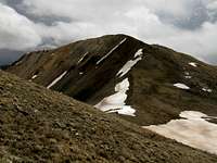
Peak 12752 is a seldom visited ranked 12er. This unnamed peak lies along the continental divide south east of the Loveland ski area between Golden Bear Peak and Loveland Pass. This peak is very solitude in a very busy area. Thousands of people pass by and see this mountain along I-70. The face of this mountain is a nasty deteriorating slope of rotten rock that is unclimbable. The continental divide provides reasonable routes to reach the top from either direction. The views on top provides a great view looking toward the Ten Mile Range. This is also a great peak to hike along side with Golden Bear Peak.
Colorado Rank: 818th
Prominance:372 feet
Quadrangle: Loveland Pass
Getting There/Routes
From Denver, Take I-70 West approximately 53 miles to the Loveland Ski Area. Parking at the Loveland Ski area is closed in the summer. You will need to park along the shoulder of the off ramp before you head under I-70.This peak can also be reached from Loveland Pass. Park at the top of the pass.
Routes:
There are 2 main routes from the Loveland Ski area, both follow the the Continental divide.
Northeast Ridge Route: This is the easiest and most logical route. You can pick and choose how you want to get to the continental divide. It's pretty straightforward. Once on the divide, continue south up the steep slope to the top of the peak. I would recommend taking the same route down.

West Ridge Route:
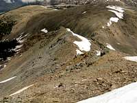
This route is undesirable and I do not recommend it. Hike northeast through the ski area reaching the willows. These willows are not the worst I've seen in Colorado, but they still are a pain in the butt. The area is also a bit marshy. Aim towards a rocky area heading up the saddle. This rocky climb is not bad and is probably the best part of the route. Once on the divide head east up the pain in the ass slopes. Some of this climb up is very steep on slippery scree slopes, while other parts of the ridge is steep on stable slopes. If you don't like willows, marshes, or scree, stay away from this route. If you want the challenge, knock yourself out!
If you start from Loveland Pass you will encounter these scree slopes, so starting at a higher elevation does not mean you’re taking the easiest route up.
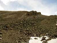
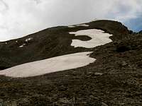
 Marshland higher up in the basin Marshland higher up in the basin |  this creek leads the way up the basin this creek leads the way up the basin |  Rocky slopes to gain the continental divide Rocky slopes to gain the continental divide |
 |  The route follows the ridgeline The route follows the ridgeline | loose steep scree slopes along the CD |