
-
 9250 Hits
-
 84.82% Score
-
 19 Votes
|
|
Mountain/Rock |
|---|---|
|
|
37.69625°N / 107.5774°W |
|
|
San Juan |
|
|
Hiking, Mountaineering, Scrambling |
|
|
13478 ft / 4108 m |
|
|
Overview
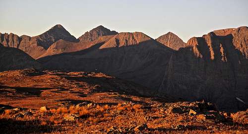
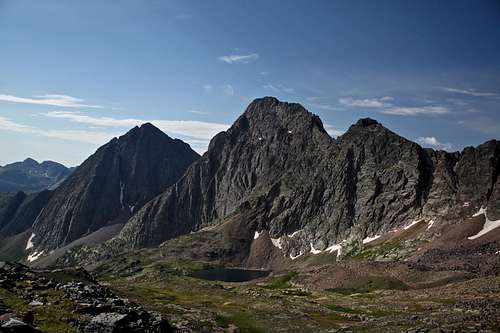
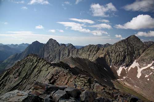
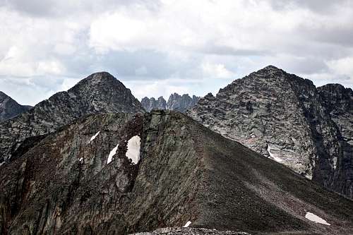
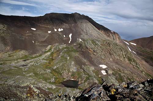 Peak Three as seen from the west ridge from Peak One
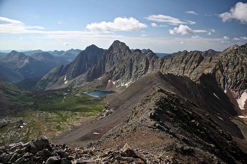 Storm King Peak from south ridge of Peak Three
Peak Three is often climbed together with Peak Two. Some people make a bigger and much harder loop combining White Dome, Peak One, Peak Three and Peak Two - a complete clean out of the northernmost 13ers on the Storm King quad.
Another combination is to hike over from Trinity Peaks if you still got some energy in you after traversing those three peaks.
Do not confuse Peak Three (letters) with Peak 3 (numbers). Peak 3 is 12,676 foot peak located in Tenmile Range.
Guide to the Colorado Mountains with Robert Ormes (sort of a bible of Colorado Mountains) again does not provide much information: "To gain Peak Three (13,478') from a camp in the Vestal Creek drainage, climb steeply out of the drainage to the flats above 12,800'. Walk up the west ridge. A moderate climbing route also is possible by way of Vestal Creek - Trinity Creek saddle and the south ridge".
The San Juan Mountains: A Climbing and Hiking Guide by Robert Rosebrough offers very little as well: "To the north, Peaks One, Two and Three, and White Dome separate the Grenadiers from Continental Divide". The routes Rosebrough mentioned are different that the route I took. See route section below.
Elevation: 13,478 = 4108 meters
Colorado Rank: 268 (I guess a tricentennial peak, among highest 300 - just for those who finished bicentennials :)
Class: 2
Line Parent: Trinity Peak
Nearby Peaks:
- Trinity Peak (= middle Trinity) (13,805 feet = 4207 meters) 0.82 miles
- East Trinity (13,745 feet = 4189 meters) 0.83 miles
- Peak Two 0.84 miles
- West Trinity (13,765 feet = 4195 meters) 0.92 miles
- Peak One (13,589 feet= 4142 meters) 1.10 miles
- Vestal Peak (13,864 feet = 4226 meters) 1.47 miles
- Storm King Peak (13,752 feet = 4192 meters) 1.68 miles
- Arrow Peak (13,803 feet=4207 meters) 1.81 miles
- White Dome (13,627 feet = 4154 meters) 1.78 miles
- Peak Eight 1.83 miles
- Peak Seven 1.99 miles
- Peak Nine (13,402 feet = 4085 meters) 2.06 miles
- Hunchback Mountain (13,136 feet = 4004 meters) 2.59 miles
Getting There
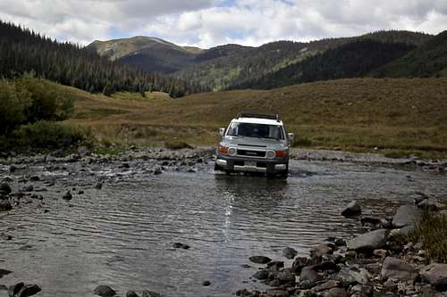 Crossing Rio Grande on the way to Beartown
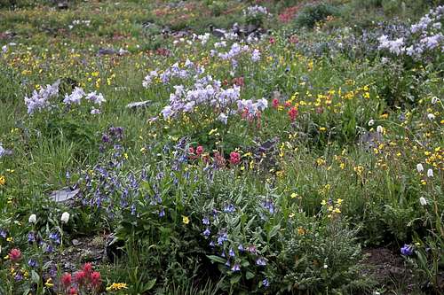 Wildflowers - Stony Pass
What is your priority? If you wish to climb only Peak Three and avoid long rough 4WD road, access from the upper Vestal Basin is your best option. You can take either a train (scenic Durango-Silverton rail) to Elk stop and hike from here into Vestal Basin. Most people wish to combine this peak with others since it is hard to approach. If combining with other numbered peaks (One, Two and White Dome) then access from Beartown/Kite Lake is better.
As mentioned above Peak Three is located deep within the Weminuche Wilderness of the San Juan Mountain Range. The shortest way to reach it is via 4WD road to Beartown (there is nothing left of Beartown, do not expect even a ghost town). You need a high clearance vehicle since you will need to cross several streams, including Rio Grande. Water levels vary based on conditions, e.g. recent rain or spring time run off from melting snow. (We found it pretty deep even in early September in 2015, July 2016 was less deep).
The road to Beartown is accessible either from Silverton or from Lake City/Creede/Rio Grande Reservoir. I would recommend driving in from Silverton - shorter, and easier. I drove it both ways and found the road towards Rio Grande Reservoir in a bad shape - mostly water damage, would not want to take my car on it again (September 2015). The road from Silverton is in much better shape and faster.
 Trinity Peaks as seen from Continental Divide Trail
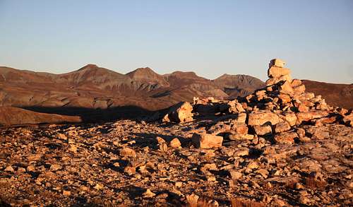 Along Continental Divide Trail
 Peak Two as seen from Continental Divide Trail
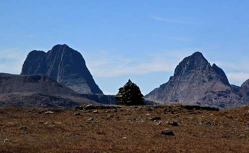 CDT with a view of Arrow and Vestal Peaks
From Lake City/Creede: again, I am not recommending taking this route, longer and in a worse condition, especially after a rain. Take Colorado Highway 149 to FS 520 and turn west toward Rio Grande Reservoir. There are several river crossings, deeply rutted sections, lots of deep puddles after a rain, narrow rocky steep sections making passing vehicles in an opposite direction impossible. It is about 25 miles long to get to the turn off for Beartown.
Once you have reached FS 506, the road to Beartown is another 4 miles (6.5 miles to Kite Lake). You have to cross Rio Grande right at the start of this road, the water can be pretty deep. The rest of the road is not bad, can get muddy after a rain and towards the end there are some rocky sections. I usually stop somewhere around mile 5 at the Continental Divide Trailhead/Hunchback Pass trailhead. There is a sign/kiosk at the start of the trail and enough place to park 2-3 cars, there are a few more car parks nearby (above the kiosk). The last mile of the road towards Kite Lake gets progressively worse.
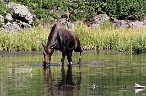 Thirsty Moose - by beaver ponds
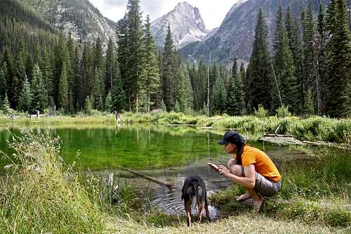 Resting by beaver ponds
On foot approaches:
1. Approach from the Highland Mary Lakes/ end of Cunningham Gulch out of Silverton. Passenger cars can make it close to a trailhead (to reach the actual TH it is better to have a 4WD - stream crossing required). You could either start your hike towards Highland Mary Lakes and turn off towards Continental Divide Trail less than 1 mile in skipping the lakes, or you can hike all the way through Highland Mary Lakes and connect with Continental Divide/Colorado Trail later on. The second options is slightly longer, but very scenic.
Expect hiking on a well established trail, well marked, well engineered cairns along the trail, incredibly beautiful scenery, and one of the best views into the Grenadier Range. The hike quickly ascends to above 12,000 feet and you continue your approach above the tree line and in a high elevation (keep this in mind during summer monsoon season). It is roughly 6-7 miles in (I did not measure the distance) to reach the Eldorado Lake below White Dome. Eldorado Lake is a great place to set up your campsite. This is the easiest and quickest backpack option for reaching White Dome and Peak One, and Peaks Three and Two.
There could be a slight variation to this backpacking option: drive to the east side of Stony Pass and hike Continental Divide/Colorado Trail from there. It would shortly connect with above mentioned Highland Mary Lakes trail and you would not have climb as much on your foot since your start would be already above 12,000.
2. Backpack from Molas Lake - Take Colorado Trail down Elk Park, cross the Animas River (nice footbridge), hike along the Durango Silverton Railroad for a short distance and continue on Elk Creek/Colorado Trail past beaver ponds towards the point where Colorado Trail connects with Continental Divide Trail. This approach is very long, requires a lot of ups and downs. The trail along Elk Creek is incredibly scenic and offers nice views into Grenadiers. The final ascent to reach the intersection of Colorado and Continental Divide trails goes through many switchbacks on grassy slopes, which are covered with wildflowers in the summer. It is less than 1/2 mile from here to reach Eldorado Lake. You don't need a 4WD car at all - you park along the main road 550, just below Molas Pass. Most people take two days for this approach. Camping along the Colorado trail is amazing - great primitive campsites.
3. Another variation of backpack from Molas Lake - you start as above, but at beaver ponds you turn off south towards Vestal Basin - this gives you an opportunity to explore Arrow Peak, Vestal Peak and Trinity Peaks. You can cross via Trinity Pass (expect a lot of scree over the pass) and drop into upper Stormy Gulch, or from the pass ascent Peak Three. You can access Peak One from upper Stormy Gulch by gaining its west ridge. (If you drop down from Trinity Pass towards Trinity Lake, you are in a great position to climb Storm King Peak, Silex and Guardian).
4. Stormy Gulch Approach - if planning a little backcountry experience - start at rough 4WD trailhead at Beartown, hike over Hunchback Pass - consider a quick stroll up Hunchback Mountain, descend down to Vallecito Creek, cross it and ascend up Stormy Gulch. Again, this approach is great if you want to climb Storm King Peak. The trail up Stormy Gulch is pretty non-existent now - too many fallen trees covered up the trail. The trail does re-appear higher up. Past Trinity Lake you ascend Trinity Pass and can go over Peak Three towards other numbered peaks and White Dome.
Route
As any mountain, there are many ways to get to its top.
The summit is nothing more than the highest point along the ridge marked with a cairn. There was no summit register there (2016).
Northwest Face - From the Vestal Creek drainage, use the same initial approach as for Peak Two: from 11,400 feet in the Vestal Creek drainage across from Vestal Peak, climb up the steep north side of the drainage which flattens out at 12,800. Once on top, walk over to the 12,940 foot saddle between Peaks Two and Three. The saddle can be also reached by climbing up the scree from the Elk drainage. Once on top at 12,800, the northwest face is a class two talus field. I have not used this approach from Vestal basin - it looked like tons of screen. I did descend the saddle between Peaks Three and Two into Elk drainage - scree is ok to ski down per my opinion, but really heinous for the ascent.
East Face - From the Trinity Creek drainage, hike up to the base of the east face which is composed of a large, stable talus field. Climb directly up the talus field to a false summit and then walk the ridge to the true summit. This was my way of going up from Peak One.
South Ridge - I have not explored this one, but heard of climbers traversing from Trinity Pass after completing Trinity traverse. Basically, East Face route the way I chose it brought me up to this south ridge and from here I continued to the highest point.
 West Ridge from Peak One to Peak Three - summit on the right. It was super windy on this ridge. Technically, this is still part of Peak One descent - fun little ridge.
 | 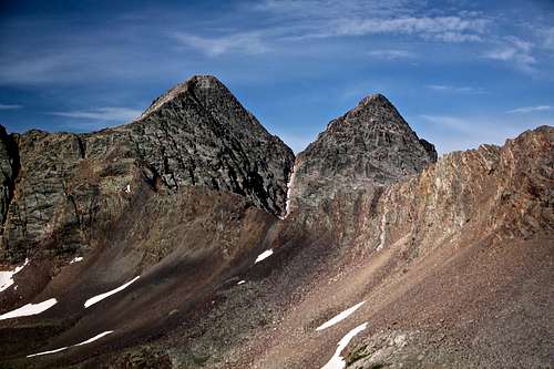 Trinity Pass as seen from descending west ridge of Peak One (Trinity and West Trinity)
 |
 View into Storm Gulch with Storm King Peak and Mt. Silex
 | 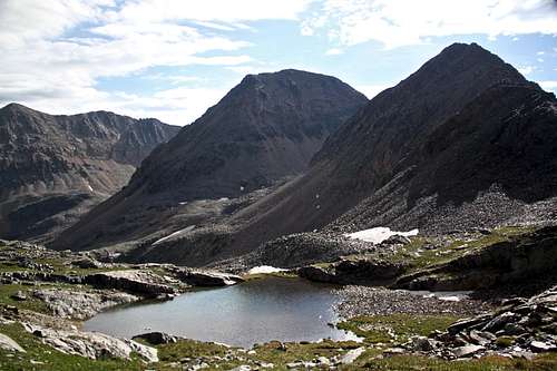 Peak One from east slopes of Peak Three
 |
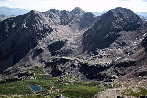
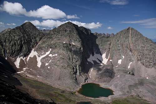 Trinity Peaks from Peak Three
 | 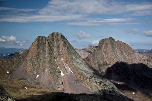 Vestal and Arrow Peak from Peak Three
 |
 Peak Three south ridge leading to Trinity Pass and West Trinity above
 | 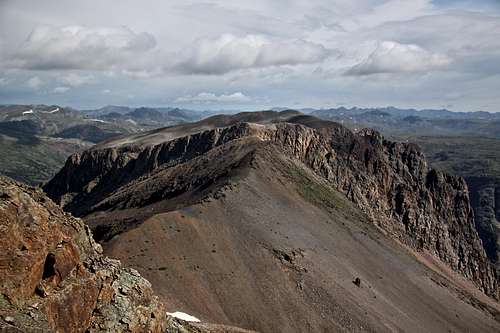 Peak Two as seen from Peak Three
 |
 Peak One and White Dome from Peak Three
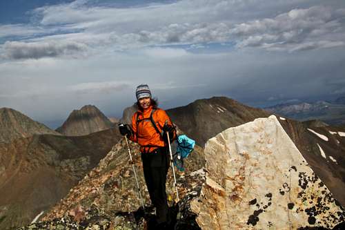
 | 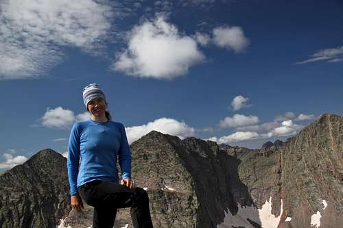 Summit pose - Peak Three
 |
 Peak Three as seen from Peak Two - Jagged Mountain between Trinities
 | 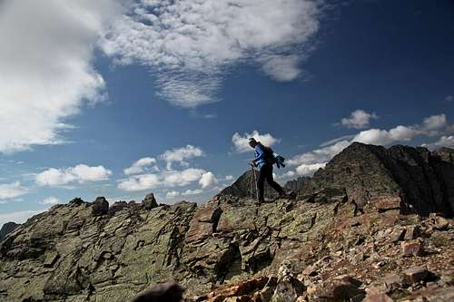 North Ridge - Peak Three (north ridge changes into more open slopes)
 |
Red Tape
National Forest Service does not require purchasing permits when visiting wilderness. Hiking, camping and driving 4WD roads is all free.When to Climb
Summer is the easiest since the mountain is so for away from civilization. A winter trip would mean a travel for several days through avalanche prone country. The 4WD road to Beartown does not usually open till June and closes late in September (when the first snowstorm hits)Camping
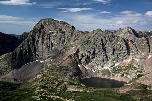 Storm King Peak and Storm Gulch
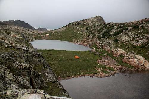 Camping Eldorado Lake
Camping at Eldorado or Vallecito lakes if considering also White Dome and Peak One. Great camping is available at Eldorado Lake. Eldorado Lake is big and offers multiple private spots for camping, just keep in mind you are in a high country > 12,500 feet. There are no trees around to make a fire. The temperature changes quickly and it does get cold at night (I camped there once on October and the lake froze by am).
Vallecito Lake would be another good place for camping.
It is easy to access the saddle between White Dome and Peak One from both lakes. I think the access to the saddle appears easier from Vallecito Lake).
Another option for great and scenic camping and would be upper Storm Gulch. The views of Storm King Peak and several small lakes offer truly a spectacular place to spend a night.
Upper Elk Creek drainage (drainage between Peaks One, Three and Two) has a nice lake and offers nice camping. It is just hard to get there. There is no established trail leading up there. Dropping from here down to Colorado Trail meant a lot of boulder/talus hopping and bushwhacking.
Basically, you are in a wilderness area and basically you can camp anywhere.