
-
 39259 Hits
-
 90.71% Score
-
 33 Votes
|
|
Area/Range |
|---|---|
|
|
37.68699°N / 107.58558°W |
|
|
Mountaineering |
|
|
Summer, Fall |
|
|
13500 ft / 4115 m |
|
|
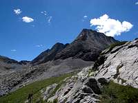
Overview
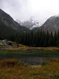
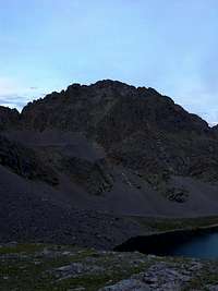
Stretching in an eight mile arc from the Animas River canyon to Vallecito Creek, the Grenadier Range lies at the heart of the San Juan Mountains. The range features solid quartzite bedrock, which in many places rises as intact slab to form entire peaks. The topographic relief in this range is extreme and compact: any route into or through it will be challenging and strenuous. At the same time, it is entirely possible to pass a full week here without seeing a single person.
The purpose of this page is to share knowledge on the Grenadier Range. I have made five extensive backpacking trips to this area so far, the last two being complete lengthwise traverses between Vallecito Creek and the Animas River. The range lies entirely within the Weminuche Wilderness of Colorado, and access to it will include unmarked social trails.
__________
As always, please do your best to learn about and practice leave no trace ethics. For climbers and mountaineers especially, this means being conscious of what is happening with social trails that cross the slopes and tundra. Scarring and erosion by our own feet are serious problems and there's no CFI up here to help out. Unwittingly, even the most pristine areas can be loved to death. Please tread lightly.
Getting There
Any trip into the Grendadier Range will involve a backpacking trip of at least one night.
From the west:
Your first objective is to reach the Elk Park trailhead on the Colorado Trail. This trailhead lies in the bottom of the Animas River canyon, and it is also serviced by Durango and Silverton Narrow Gauge Railroad. You can either pick up the morning train in Durango, or you can pick up the afternoon train returning from Silverton.
Alternatively, you can descend from Molas Pass at highway 550 to reach Elk Park. This segment of the Colorado Trail descends 2,000 feet over two and a half miles, with a seemingly endless series of switchbacks on the final stretch into the canyon. While this isn't too bad packing in, the trip out of the canyon is strenuous and tiring after a long trip.
Once at Elk Park, take the Colorado Trail east up Elk Creek for three miles until you reach a series of beaver ponds that lie on the south side of the trail. Contour south along the east edge of the water, picking your way around the base of a large boulder field. When you reach the south side of the ponds, you will find a good camping area and a social trail that continues south and before descending into Elk Creek. Cross the creek and continue in a southerly direction until you reach Vestal Basin.
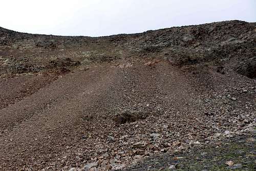
The social trail into Vestal Basin is very steep. Be careful of two areas where the trail threads apart. You generally want to stay to the left and aim for constant elevation gain. About two-thirds up to Vestal Basin there is an area where the trail makes a direct climb up a scree slope. It is tedious and eroded, but there is no way around it. Once past this spot, the trail will even out and contour high above the creek into Vestal Basin. Next, the trail starts to descend a little bit before encountering a small boulder area. (Point of interest see below.) Follow the cairns through the boulders and then continue on a modest grade uphill. Not far from this point the basin opens up and you will be able to find several good camping spots. After the beaver ponds at the Colorado Trail, there are no suitable camp areas along the social trail until you reach Vestal Basin.
Point of interest: On the way back down from the camping area, you cross the small boulder field and come back to this point- now a surprising rise in the trail when you would expect it to keep losing elevation quickly. Remember to stay right on the way down the trail. Immediately past the cairned boulders, the correct trail heads upbruptly right and uphill at the same point where the lower threaded trail takes off to the left and downhill. The lower trail should be barricaded with branches, but it is easy to miss this because it is well tracked out. You know if you are on the lower trail if you continue to go down through a slab couloir that is filled with trees, quickly re-approaching Vestal Creek. While you could probably follow this route past the cliff area to the creek bottom, the good trail stays right with a short gain and remains high above the creek until returning to the scree pitch described above.
From the east:
Your objective is to enter Vallecito Creek (pronounced "Vai-eh-ceeto".)
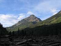
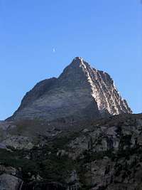
If you head north up Vallecito Creek, the Guardian watches over your approach the whole time. The way up the creek is a 14 mile backpack, with off-trail sections that follow Leviathan Creek or Trinity Creek. The trail up is a long, though pleasant grade for a backpacking trip. There are several fine places for camping in the lower sections of this trail, but I remember an upper section near Rock Creek that was confined with steep slopes and marshes. After this spot there are many good campsites on either side of the confluence with Rock Creek.

If you come down Vallecito Creek from Hunchback Pass, the best campsite in the area is immediately below the Mt. Nebo (CDT) trail junction. Below this campsite the trail pitch is steep and good camping does not come up for at least another mile until the Rock Creek area.

There have been trip reports of a social trail that extends up Leviathan Creek, but I have not been able to spot it. There is a faint trail in parts of Trinity Creek, but locating it from inside Vallecito Creek is not easy. This side of the Grenadiers is true wilderness and I would rely more on using game trails or traveling off-trail entirely.
A trip to the Mt. Oso group would be a good reason to focus on the Weminuche's more remote eastern approaches. Why is this worth mentioning in the Grenadiers page? Mt. Oso is part of the Uncompahgre Formation. A.k.a. this is the same solid, maroon quartzite and uplift process that formed the Grenadiers...and which circles the underlying Eolian Grante of the Needle Mountains. In many senses, the Mt. Oso group is a natural spur of the Grenadiers heading southeast from upper Vallecito Creek. It is part of a long trend of faults and the same quartzite can be found in the Brazos Cliffs area of New Mexico.
Once inside the range
You have many alternatives from the campsites in Vestal Basin.
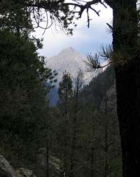
From this area most people aim to climb either one of the Trinity Peaks, Vestal Peak, or Arrow Peak. Vestal Peak is probably the most popular because of its...unreal...Wham Ridge. Electric Peak is probably the least climbed in this area because it is relatively lower, and it also involves some backtracking and re-descent to the west.
A crowd in this area means that there are one or two other groups camped nearby. If for some reason you need more space, or if you are looking for a base camp that is closer to the Trinity Peaks, continue east on the Vestal social trail past the first group of campsites. You will quickly enter a treed area and the trail starts to wind up through some modest cliff areas and rock outcrops. There are additional campsites about half way up through the rock outcrop, and another at the banks of the creek in the next hanging valley.
There is a spur trail from the first camp area that heads immediately toward Vestal Peak. It's a beeline approach to the mountain, but it ends up going straight for some of the steepest sections of quartzite and the worst patches of brush. I downclimbed this route and I thought it was very tedious. To access the peaks from the first camp area, I recommend heading east instead, staying on the trail through the second camp areas described above. Once you reach the next hanging valley, move right (south) of the creek and aim for the next series of quartzite ledges. These ledges are better contoured, and I think, easier than negotiating the marsh on the north side of the middle hanging valley. Once gained, these ledges help you avoid the worst of the brush and deliver you onto the east flank of Vestal's Wham Ridge. From there you can easily contour west to Arrow, east to the Trinities, or straight ahead for Vestal.
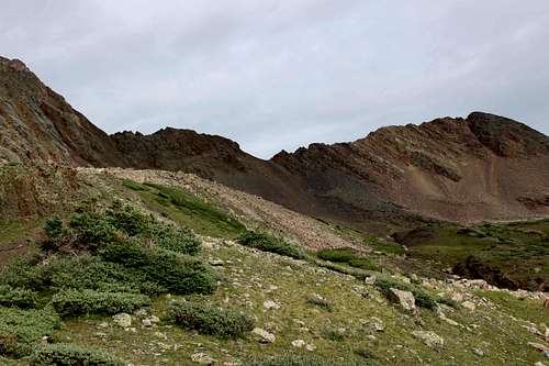
Once at the eastern base of Wham Ridge, take a look at the topography and you will see that there are two options for continuing through this mountain range. First, look northeast past the Trinities. Vestal Basin tapers out and there is a pass leading to Trinity Creek and Stormy Gulch below. (Unnamed East Trinity Pass #1.) Next, look south to the pass between Vestal and West Trinity Peak (Unnamed West Trinity Pass #2.) You will want to take this pass for standard routes up Mt. Silex or the Guardian, or if you wanted to turn south toward Jagged Peak and the Needles.
If you have come in from Vallecito Creek then your goal is to locate either Leviathan Creek or Trinity Creek. Continue reading in the next section for these areas.
The Passes
Unnamed "East Trinity Pass #1":
Vestal Basin to Trinity Creek and Stormy Gulch
This route will take you between Vestal Basin and upper Trinity Creek.
From the eastern base of Wham Ridge (or however you chose to climb up from the marsh) continue east below the foot of the Trinities. The valley tapers out, and a long ridge wraps around the basin between East Trinity Peak and Peak 3. At the lowest saddle on the far right (south) is an obvious pass: a scree march and climber's access to East Trinity Peak. It's another beeline approach that doesn't make the best sense for all occasions. If you intend to make the traverse to Trinity Creek and not to summit East Trinity Peak, look straight ahead to a class 3 area between the scree gulley and the cliffed areas farther left, below Peak 3. Although you gain a little more elevation on this route than when using the scree gulley, it is probably much easier with a pack because the material is much more stable.
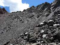
Work around the lower talus piles by first staying right, and then contour left and upward around the base of the most solid rock. If necessary, travel up the more solid areas of talus flow (darker) and avoid crossing the scree (lighter color.) The material consolidates into a fairly stable class 3 pitch, and then you can work your way up through a ledge system to the next highest saddle between the scree gulley and Peak 3. Now you have two options. Either downclimb eastward on loose talus, or follow the ridge north to Peak 3 and then descend eastward from that mountain. The east slopes of Peak 3 have some rather stable talus and boulder fields, and this may be a preferable descent to the broken talus immediately below the middle saddle.
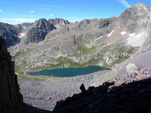
When you descend from either the middle saddle or the east slopes of Peak 3, angle southeast and downward to approach Trinity Lake. Immediately north of the lake, a social trail forms and leads down to the two smaller ponds. The trail disappears here. Now move in an east-by-north-east direction, away from the two ponds. While descending, cross to the northeast side of Trinity Creek through a series of easy gulleys. Make sure to cross north of the creek and its tributary gullies early, because the creek becomes incised on its way down to the hanging valley below. You should come down through the trees into the next hanging valley with Trinity Creek on your right. Cross the long meadow and aim directly for a campsite that lies on its most eastern end. The creek draws near to this campsite and begins to drop out of the hanging valley. From the campsite, cross to the south side of the creek and find the faint trail that continues downward. You can now use this trail, such as it exists, to go down to Vallecito Creek. Continue reading the next paragraph for information about the lower part of this trail.
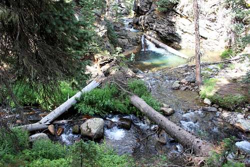
From Vallecito Creek it will take a little effort to find Trinity Creek. Heading down from Hunchback pass, continue past the Mt. Nebo trail and down the steep series of switchbacks to Vallecito Creek. Near the bottom you will hear a waterfall area. The very last switchback provides an excellent view of the waterfall. Pay very close attention to this area, because the confluence of Trinity Creek and Vallecito Creek is just below this waterfall. Continue south on the trail until you find the first open meadow on the west side of the trail. Now turn a complete 180 and look behind you to see how Stormy Gulch enters Vallecito Creek. If you are coming up Vallecito Creek, you find that this is the last meadow before the first switchback on the way up to the waterfall.
Leave the Vallecito Creek trail at this meadow and walk northeast to a camp area on its far side. Turn left to cross Vallecito Creek, and once on the other side, be sure to turn right again and keep walking northeast. You are now in the trees and your landmarks are hidden. Slowly gain some elevation while keeping Vallecito Creek on your right. Suddenly you come to a high point with Vallecito Creek on your right, Trinity Creek ahead (and below you) and a view of the waterfall that was described at the last switchback on the way down Nebo Creek. Now turn left and follow the high banks of Trinity Creek east and upward. Be sure to keep Trinity Creek on your right (and not accidentally return to Vallecito Creek.) You will also find that the ledges above Trinity Creek lead you away from the water a little bit, but the creek stays within earshot. Soon enough a faint trail should appear. Use this trail where it can be followed, contour the south side of Trinity Creek all the way to the hanging valley described two paragraphs above.
Unnamed "West Trinity Pass #2": Vestal Basin to upper Noname Creek.
Look south from the east flank of Wham Ridge and you will see a large valley filled with talus. In the distance there is a long ridge stretching between Vestal and West Trinity Peak. This ridge offers a pass leading to upper Tenmile Creek, and farther, Leviathan Creek.
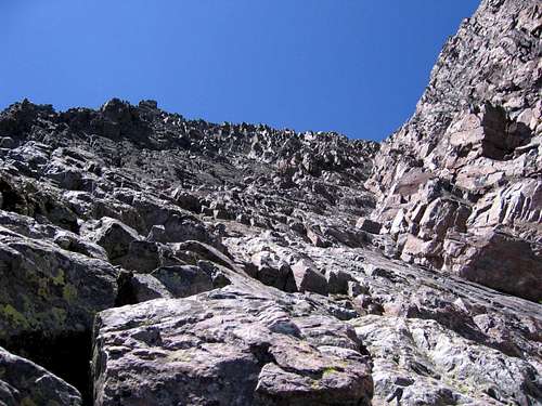
To approach this pass, travel southeast across the boulder valley from Wham Ridge until you reach base of West Trinity Peak. You will immediately find that it is a 3rd class scramble (and a full pack certainly doesn't make it all that appealing.) There are truck-sized boulders strewn around loose talus and rotten scree. Each time I have been to this pass I have done my best to find stable material--only to end up on scree and cursing each time. Do your best to gain the ridge while contouring left toward the saddle.
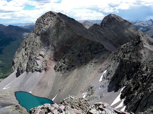
Once on the ridge, there are two possibilities. First, you can descend to Balsam Lake, where there are fabled routes over to Noname Creek and the Needle Mountains. But if your goal is to access the remote peaks of the Grenadiers, gently descend south from West Trinity Pass and begin to contour in an easterly direction. After a few minutes you will come around the mountainside and be rewarded with one of the most stunning landscapes in all of Colorado.
The last time I was here there was a network of cairns to help guide your traverse east, and below the southern flanks of the Trinity Peaks. Your goal is to contour 1 mile east into a high valley where two small ponds lie at 12,200'. This is immediately west of Storm King Peak. From West Trinity Pass, descend and contour across the talus until you begin to approach some thin sections of trees. At this point you will also see that there are a series of rock faces below Middle and East Trinity that block a direct traverse into the high valley.
Although sparse, the tree sections are tricky. When you reach the first one, you will be tempted to stay high so as to traverse above the trees and the rock faces all together. Do not do this because as you near the high valley, you will be pinched out by some cliffs. Instead as you approach the trees, set your eyes on the lowest and farthest section of the rock faces, below the two ponds in the distance. Imagine a straight traverse over and down to the very bottom of the last rock face. Each time you head into the tree gulleys be careful of slick tundra on steep pitches. However there is some stable talus in the gullies between the trees that will help you quickly loose elevation.
In this sense you should be able to contour down and through each section of trees, and then loose your elevation by downclimbing through the small rock gullies. Each time you come out of the trees, locate the last and lowest section of rock face. You should come right down to the bottom of the last rock face. From here you only need to regain about 100 feet of elevation as you continue your traverse into the high valley below Storm King Peak. There are suitable campsites on a rocky knoll between the two small ponds. From this campsite you can access Peaks 7, 8, and 9, as well as Storm King Peak, Mount Silex, and the Guardian. It is also possible to reach this area and one of these peaks as a day hike from the Vestal camps, but when I tried that one year to access Storm King Peak, it easily became a 12 hour day with very little time for rest or photography.
Unnamed "Storm King Pass" and Lake Silex Basin
Two guidebooks on the area advise gaining the pass at the saddle between Storm King Peak and Peak 9, above Lake Silex, in order to climb Mount Silex and the Guardian. One says to contour high above Lake Silex, while the other recommends to drop down to the lake. In either case you would ultimately finish at the second pass below the southwest ridge of Mount Silex.
It is definitely worthwhile to hike up to the "Storm King Pass" from the two small ponds. This is the best approach to summit Storm King Peak, and the view from this pass is beyond description. But practically speaking, I have attempted the high traverse across the Lake Silex Basin on two separate trips, and both times I simply did not like it. As you first descend east from the pass below Storm King Peak, the normally purple quartzite becomes a beautiful dark maroon. A stable descent on large boulders seems easy at first, but the terrain quickly spills into masses of scree that have been wasting away the millennia below the north face of Peak 9. In my mind this area is sketchy, and at best, it is a fully unpleasant and torturous route.
Unnamed "Leviathan Creek Pass"
Returning to the campsite at the two small ponds, a far better route is to continue in a southerly direction and gain the pass below Peaks 7 and 8 to a tributary stream of Leviathan Creek. Pass the small pond at the summit and descend southeast below Peak 7 to the larger lake below Peak 9. Take note of the unusual geologic fault in this area, but be careful not to fall into it! Once at the large lake, do not continue a descent along its outlet stream. Instead, cross the stream at the lake outlet and head due east over the hills and tundra into a second small drainage that runs along the base of Peak 9. Follow this small drainage southeast, along the point where gentle grassy slopes meet the talus piles at the bottom of the mountain. Peak 9 can be accessed from this area. The south face of Peak 9 is not the most dramatic, but there are some excellent class 3 and 4 routefinding possibilities here that will lead you to the summit.
Southern route to Mount Silex, the Guardian, and exit through Leviathan Creek
As you gently descend along the base of Peak 9, what looks like a ramp on the topo map suddenly sharpens its drop into Leviathan Creek. At this point leave the tundra and start contouring across the talus to access Mount Silex and the Guardian. You may find a faint trail and a few cairns in this area, which probably mark a route up the long southeast ridge of Peak 9. But if you are heading to Mount Silex and the Guardian, do not take these routes because you will get pinched out by significant exposure on the east side of the ridge.
Instead, continue a gentle descent southeast though the talus and come around below the long ridge of Peak 9. You will come into an unnamed basin that forms a south-facing saddle between Mount Silex and the Guardian. From here there are straightforward class 3 scrambles up to each peak. You can also backtrack to gain the southwest ridge of Mount Silex for a more challenging ascent to that summit.
From the low point in this basin, you can either retrace your paths back to the Animas River, or you can look for the elusive Leviathan Creek social trail and exit the Grenadier Range. From treeline at the bottom of this basin, it is 1.5 miles and a 1,800' descent to the Vallecito Creek Trail. I elected to return through Vestal Basin.
Options:
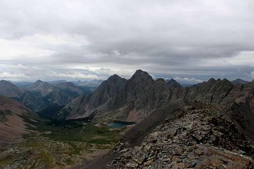
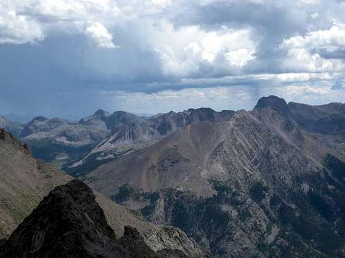
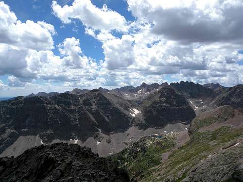
The Guardian offers a rare opportunity to survey large expanses within the central San Juans. If you make it across the Grenadiers to the summit of this mountain, take note of the backcountry possibilities leading into the Needle Mountains, and also to the Mount Oso group east of Vallecito Creek.
Red Tape
The entire range is located within the Weminuche Wilderness. There are particular rules to traveling in a wilderness area, and some apply to specific areas such as nearby Chicago Basin or Emerald Lake. Namely you should be careful that group sizes are strictly limited. It is a good idea to call up the San Juan Public Lands Center in Durango to inquire about current conditions and pertinent rules before you begin your trip.
Rocks and geology
For some, one of the best things about mountaineering is to look at the rock types and to think about the geologic processes that formed the current landscape. The San Juans are not a dull place to think about geology.
It is well understood that the current shape of the Grenadiers was created about 30 million years ago by Tertiary volcanic activity occurring in the greater San Juan region. However the rock type of the Grenadiers is of a much older origin than the heat sources that created the San Juans.
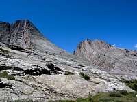
The Grenadiers are "composed of hard quartzites of the Uncompahgre Formation. Vestal, Arrow, and Garfield Peaks were hewn from these quartzites, perhaps the hardest of all naturally occurring rocks." This quartzite was present long before the intrusion of the Eolus granite which composes the Needle Mountains. As the magma that formed the Eolus granite pushed upward, it heated the overlying layers to near melting point, and then forged them through a metamorphic process that created the beautiful "ramps" we see in the range today. (See Origin of the Landscapes, below.)
These "overlying rocks mark the beginning of vigorous uplift in the central and eastern San Juans that culminated in some of the most violent volcanic activity ever recorded on the planet."
With a sharp eye you can bring up Google Earth, and you will see how super-heated material rose upward to spread open the preexisting rock. These quartzite formations, with their melted, warped characteristics, surround the intrusive Needle Mountains in at least three directions. Evidence of this process can be seen by looking inward to the heat source from the Snowdon Peak area, from along the entire length of the Grenadiers, and even southeastward through the Mount Oso group. If you have the chance to use Google Earth, it is also worthwhile to check out the Silverton and La Garita calderas.
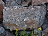

There is a lesser-known metamorphic layer underneath the quartzite, and which is equally beautiful but more puzzling. It can be found in the eastern Grenadiers and also I have found it in areas far below Snowdon Peak. I can only imagine that this particular rock type was actually liquified, but not quite recycled back to igneous rock. I would be happy if someone from the SP community could help me identify it!
Finally, glaciation removed entire mountains of material and has brought us to what we see today. In the lower Pine River valley you will find beautifully rounded and polished riverstones that are the exact same rock type as what you see up on Vestal Peak. In the Animas River valley there are massive boulders lodged high above the valley in moraines and terraces, and which are basically the detritus that has come down from the areas of Eolus granite.
External links
San Juan National Forest
San Juan Public Lands Center
Origin of the landscape