
-
 35763 Hits
-
 92.85% Score
-
 40 Votes
|
|
List |
|---|---|
|
|
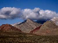
Summits of Red Rocks, Nevada
This list includes peaks made out of Aztec sandstone which Red Rocks area is famous for. The only exception being Turtlehead Peak which is in limestone and located close to and easily accessible from the Sandstone Quarry.
Clicking on a mountain name will take you to its page on SP if such exists.
| Rank | Name of the Peak | Photo of the peak | Elevation in Feet | Location |
|---|---|---|---|---|
| 1. |

|
7,070
|
It lies between First Creek and Oak Creek Canyons
|
|
| 2. |
|

|
7,047
|
It lies between Icebox Canyon and Rocky Gap Road
|
| 3. |

|
6,995
|
It lies between Pine Creek and Icebox Canyons
|
|
| 4. |

|
6,924
|
It’s the Northeast face of Rainbow Mountain
|
|
| 5. |
Mount Wilson South Summit
|
 |
6,820
|
It’s a subpeak on Mount Wilson
|
| 6. |
|

|
6,800
|
It lies between Oak Creek and Juniper Canyons
|
| 7. |
|

|
6,670
|
It lies between North Fork of Pine Creek and Icebox Canyon
|
| 8. |
Lost Creek Peak
|
 |
6,664
|
It lies at the back of Lost Creek Canyon
|
| 9. |
NO PHOTO YET
|
6,650
|
It lies in the back of North fork of Pine Creek
|
|
| 10. |
White Rock Hills Peak (aka White Rock Mountain)
|
 |
6,462
|
It lies between Willow Springs picnic area and White Rock Springs
|
| 11. |
Bridge Vista Peak
|
 |
6,381
|
It’s a subpeak on Bridge Mountain
|
| 12. |
Goodman Peak
|
|
6,373
|
It’s a subpeak on North Peak
|
| 13. |
|
|
6,323
|
It lies north of the Sandstone Quarry
|
| 14. |
|

|
6,300
|
It’s a subpeak on Mount Wilson
|
| 15. |
Hidden Peak
|

|
6,280
|
It lies Southwest of the Monument
|
| 16. |
The Monument (East, Center and West)
|

|
6,252-western summit
|
It lies between Black Velvet and Sandstone Mountains
|
| 17. |
Terrace Canyon Peak
|
NO PHOTO YET
|
6,250
|
It lies at the back of Terrace Canyon (a subfork of South fork of Pine Creek)
|
| 18. |
Pine Creek Peak
|

|
6,240
|
It lies at the back of South Fork of Pine Creek
|
| 19. |
|

|
6,234
|
It lies on the South side of Black Velvet Canyon
|
| 20. |
|

|
6,200
|
It’s the highpoint of Brownstone Wall at the back of Juniper Canyon
|
| 21. |
|

|
6,200
|
It stands between Hollow Rock Peak and Black Velvet Peak
|
| 22. |
|

|
6,167
|
It lies on the South side of Icebox Canyon
|
| 23. |
|
NO PHOTO YET
|
6,120
|
It lies behind Indecision Peak
|
| 24. |
|

|
6,109
|
It lies between Juniper Canyon and the South fork of Pine Creek
|
| 25. |
Tunnel Vision Peak
|
NO PHOTO YET
|
6,100
|
It’s a subpeak on White Rock (Hills) Mountain
|
| 26. |

|
6,033
|
It lies at the back of Oak Creek Canyon
|
|
| 27. |
|

|
6,000
|
It’s a subpeak on Rainbow Mountain
|
| 28. |
White Rock Springs Peak
|

|
6,000
|
It lies Northwest of White Rock Springs
|
| 29. |
First Creek Peak
|

|
5,990
|
It lies at the back of First Creek Canyon
|
| 30. |
Hollow Rock Peak
|

|
5,950
|
It lies between South Peak and Windy Peak
|
| 31. |
Spring Mountain Peak
|

|
5,943
|
It lies between Sandstone Mountain and Indecision Peak
|
| 32. |
Global Peak
|
NO PHOTO YET
|
5,900
|
It’s a subpeak on Windy Peak
|
| 33. |
Beer and Ice Peak
|
NO PHOTO YET
|
5,800
|
It’s a subpeak on Bridge Point
|
| 34. |
Sandstone Mountain
|

|
5,796
|
It lies on the South side of Sandstone Canyon behind Spring Mountain Ranch
|
| 35. |
South Peak
|

|
5,700
|
It’s the most southernmost peak of Red Rocks located North of Highway 160
|
| 36. |
|

|
5,660
|
It lies between Sandstone and First Creek Canyons
|
| 37. |
Dead Horse Point
|
NO PHOTO YET
|
5,600
|
It’s a subpeak on Mount Wilson
|
| 38. |
Burlap Buttress
|

|
5,598
|
It lies between Black Velvet Peak and the Monument
|
| 39. |
|

|
5,500
|
It’s a subpeak on Mount Wilson
|
| 40. |
|

|
5,440
|
It lies in the center of Pine Creek Canyon
|
| 41. |
Magic Mountain
|

|
5,350
|
It lies on the South side at the front of South fork of Pine Creek
|
| 42. |
Ramp Peak (aka Crabby Appleton)
|
|
5,300
|
It lies behind Magic Mountain
|
| 43. |
East Peak
|

|
5,280
|
It’s a subpeak on the Monument
|
| 44. |
|

|
5,220
|
It lies on the South side of Magic Mountain
|
| 45. |
Whiskey Peak |
|
5,160
|
It’s a subpeak on Black Velvet Peak
|
| 46. |
Turtlehead Junior (aka Red Cap) |

|
5,142
|
It’s the highpoint of Calico Hills
|
| 47. |
Kraft Mountain |
NO PHOTO YET
|
4,217
|
It lies North of Calico Basin
|
Links to my Slideshows
Adventure Scrambles in Red Rocks of Nevada
Enjoy!
Anya Jingle - Jun 3, 2008 4:10 pm - Hasn't voted
Re: Bridge Mt Elevation; La MadreI decided to pass on La Madre. It's very anticlimactic to have a limestone peak as the high point of RED rocks. This was not meant to be a list of RRNCA area peaks. It's a list of sandstone peaks. I was considering passing on Turtle Head as well, but then I thought I'll be nice to those who are not into route finding and still would like to have at least one summit experience in Red Rocks. A list of all of the limestone peaks of the Spring Mountains (not just Mt Charleston Wilderness) would be awesome as well, but I'm not up for this task. You have more knowledge about all these peaks "behind" Red Rocks than I do. Cheers!
MoapaPk - Jun 3, 2008 4:48 pm - Voted 10/10
Re: Bridge Mt Elevation; La MadreUnderstood. The gray rocks don't look red... but La Madre is way nicer than Turtlehead. ;^) Actually, maybe we should say "light tan rocks peaks". Note the comment on White Rock Springs Peak, which I added at the same time as you were answering my other comments!
Anya Jingle - Jun 3, 2008 4:58 pm - Hasn't voted
Re: Bridge Mt Elevation; La MadreThanks for the comment on White Rock Springs Peak. It's going to take me a bit longer to move things around in a table. BTW, the elevation of Cloud Tower is only tentative. I could not find the exact one on any map.
MoapaPk - Jun 3, 2008 5:25 pm - Voted 10/10
Re: Bridge Mt Elevation; La MadreYou are close enough for Cloud Tower. It has very little prominence, and I'm not sure what it corresponds to in the 40'-contour-interval USGS map. On the USGS map, there is one lump on that side of the main mass of Rainbow Peak; that lump has ~40' prominence, and its elevation is over 5920' (the last closed contour line). However, I don't know if that point on the map is really what they call "Cloud Tower". Maybe RPC would have a guess? I've attached a map to images on the main page, maybe someone can comment.