
-
 7505 Hits
-
 79.78% Score
-
 11 Votes
|
|
Mountain/Rock |
|---|---|
|
|
44.02541°N / 10.70532°E |
|
|
Hiking, Scrambling |
|
|
Spring, Summer, Fall |
|
|
3858 ft / 1176 m |
|
|
Overview
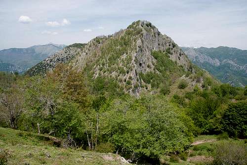 Penna di Luchio as seen from the south Penna di Luchio as seen from the south |
In the backcountry of Pescia, in an area called Svizzera Pesciatana (everything that is beautiful can be called Swiss ;-)) you can find several limestone mountains of moderate height but still imposing aspect. The area belongs to the lower reaches of the Appennino, Italy's backbone mountain range, the main ridge of which rises about 30km to the north-east. Limestone being rare in this part of the Appennino, Svizzera Pesciatana, might also be regarded as a separate range, though a rather small one. The mountains rather resemble the karst features of the southern Alpi Apuane to the north-west across the Lima and Serchio Rivers than the sandstone buttes typical of the Appenino.
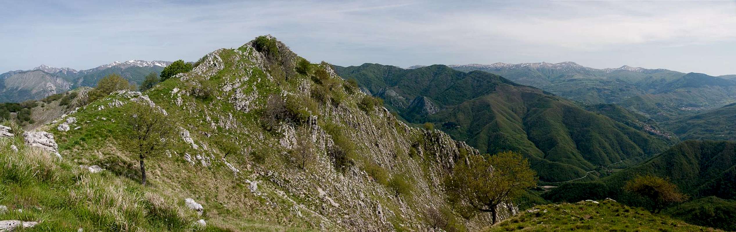
Among these mountains Penna di Lucchio takes a special place. It is an easily accessible mountain, the east face of which rises for more than 700m out of the Lima River valley. Named after the village of Lucchio, perched on a shoulder beneath the east face the Penna (= quill) is a very popular mountain, even though the regular routes cannot be called exactly easy. The normal route takes the north ridge of the mountain and is very steep and moderattely exposed. The shorter southern route, however, is a balancing act above the abyss of the east face, following the south ridge of the mountain. In addition to its steepness it is very exposed in its central section. Thanks to the blocky nature of the ridge, difficulties don't exceed UIAA II, however.
 |  |  |
Penna di Lucchio is the central and highest part of a ridge which is formed by the hill-like Monte Granaio (1043m), wood covered Monte Lischeta (1077m) and Monte Memoriante (1151m). All four are popular summits, especially during the weekends, when locals use them as panoramic picnic summits. The Penna is characteristic as its faces document the folding mechanism which created the range in the first place. The east face displays numerous near vertical layers documenting the origin but also the low quality of the limestone rock. Though the faces are very steep, the top of the mountain is relatively flat with a big sloped mountain meadow. Penna di Lucchio has three summits, the highest and central of which reaches 1176m. The north summit is covered by oak trees up to its top while the steep south summit only carries bushwork. Usually the mountain is climbed by the south route and descended by the normal route, combining both in a loop hike.
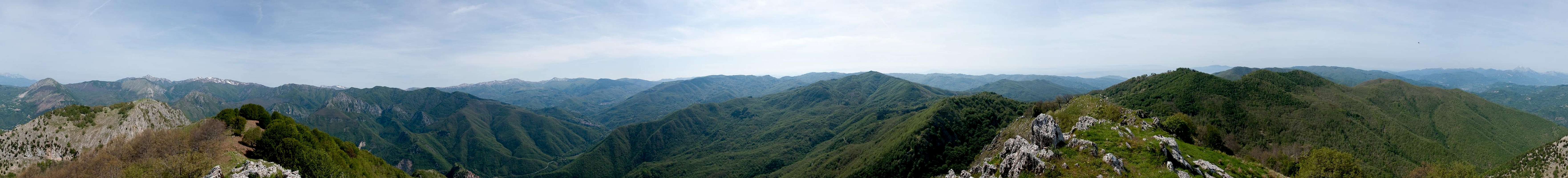
360° Summit Panorama
  |
Getting There
 The village of Lucchio above the Lima Valley
There are two possible trailheads, one at Lucchio in the north and one at Pontito in the south of the mountain. Both villages are connected by a potholed road, which is no fun to drive without a high clearance vehicle. From the two international airports of Pisa and Firenze (Florence)the itineraries are as follows:
- From Firenze
- Lucchio trailhead
- Take motorway A11 direction Pisa
- At the exit Pistoia switch to SS66 to San Marcello Pistoiese
- At La Lima switch to SS12 direction Bagni di Lucca
- After 5km follow the sign to Lucchio
- Pass the village and park your car at the entrance to the hamlet of Zato
- Pontito trailhead
- Take motorway A11 direction Pisa
- Take the exit Monsummano / Monte Catini
- Follow SS435 to Pescia
- Take SP3 to Pietrabuona
- Switch to SP34 to Lanciole il Poggetto
- Follow the signs to Pontito and there follow the signs to Croce al Veglia.
- After a few km you reach the chapel Madonna delle Grazie, where you can start the ascent
- Lucchio trailhead
- From Pisa
- Lucchio trailhead
- Take motorway A11 direction Firenze
- At the exit Lucca switch to SS12, direction Abbetone
- Drive through Bagni di Lucca and after 17km follow the (hidden) sign to Lucchio
- Pass the village and park your car at the entrance to the hamlet of Zato
- Pontito trailhead
- Take motorway A11 direction Firenze
- Take the exit Chiesina Uzzanese
- Follow SP13 to Pescia
- Take SP3 to Pietrabuona
- Switch to SP34 to Lanciole il Poggetto
- Follow the signs to Pontito and there follow the signs to Croce al Veglia.
- After a few km you reach the chapel Madonna delle Grazie, where you can start the ascent
- Lucchio trailhead
Red Tape
 Anguis fragilis
There is no red tape here. However, can find orchids on the slopes and ridges of the mountain. These flowers are protected all over Europe so leave them in their place. Also, the east face of Penna di Lucchio is nesting ground for peregrine falcons. Make sure not to disturb these rare birds, especially in the nesting season in spring.
Part of the access roads run through private property so stay on track.
Accommodation
 |
Either stay in hotels in the big towns (Pisa, Lucca, Firenze) or make use of agriturismo, the offer of rooms and apartments by local farmers. You''ll find signs along the roads and the bigger establishments can be booked by internet. The quality of the lodging differs greatly but prices are reasonable.
Weather Conditons
Maps & Books
Maps
I have not been able to find detailed maps of this area so the following one is a road map, scaled 1:150000
- Tuscanny - Florence
Freytag & Berndt
1:150000
ISBN: 978-3-7079-0281-5
Maps Online
Books
- Tuscany North / Toskana Nord
Wolfgang Heitzmann / Renate Gabriel (translation: Gill Round)
Rother Verlag
ISBN: 978-3-7633-4812-1 (English)
ISBN: 978-3-7633-4115-3 (German)