
-
 23027 Hits
-
 89.01% Score
-
 28 Votes
|
|
Area/Range |
|---|---|
|
|
44.12624°N / 10.64740°E |
|
|
Hiking, Skiing |
|
|
Spring, Summer, Fall, Winter |
|
|
7103 ft / 2165 m |
|
|
1 - Overview
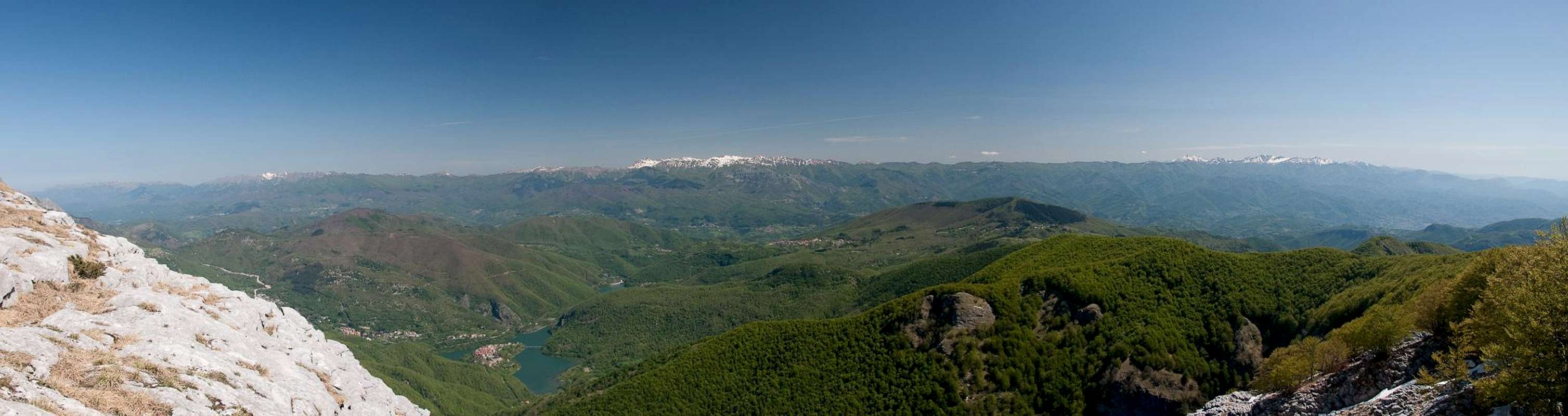
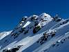
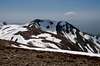
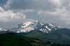
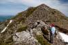
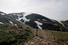
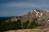
 The Corno alle Scale and Libro Aperto Groups as seen from Monte Cimone The Corno alle Scale and Libro Aperto Groups as seen from Monte Cimone |
The Appennini (Apennines or Apennine Mountains) with a total length of 1200km are among the longest mountain chains in Europe. Separated into several subranges they stretch drom Liguria in the north along the whole Italian peninsula to the Strait of Messina in the south. In fact, they even jump across the strait and form three additional subranges on Sicily before running out in the west of the island. On the mainland, the Appennini are divided in three parts,
- Appennino Settentrionale (northern Appennine)
- Appennino Centrale (central Appennine)
- Appennino Meridionale (southern Appennine),
with the highest mountains of the Gran Sasso Range belonging to Appennino Centrale. The northern Appennine again is divided in two parts, the Appenninno Ligure and the Appennino Tosco-Emiliano. The latter is the topic of this page.
|

The Appennino Tosco-Emiliano separates the Italian regions of Toscana (Tuscany) in the west and Emilia-Romagna in the east. Strictly speaking, due to the division of Emilia-Romagna, there is a distinction between Appennino Tosco-Emiliano and Appennino Tosco-Romagnolo, the latter forming the southern part (see following map). However, the northern part contains all the high mountains of the range, sometimes reaching across the 2000m line, while the Romagnolo part on the average reaches only about 1000m, with Monte Falterona (1655m) being a notable exception to the rule.
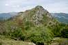
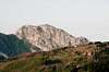
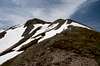
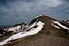
The centre of the range is made up from grey sandstone, a material, which has been quarried in the last 2000 years. However, during the ice ages, when the range was covered in glaciers, it didn’t put up many obstacles and got ground away in most of the places. Thus, with the notable exceptions like Corno alle Scale, Libro Aperto or Monte Cusna, today the ridgeline is a long chain of rolling hilltops, which stretches for about 300km between Passo della Cisa and Passo di Viamaggio. Only on the outskirts – to both the east and the west of the main ridge – will you find more impressive mountains, formed by different kinds of rocks. There the rock of choice is limestone and offers good climbing potential. Pietra di Bismantova might be an example on the eastern side of the main ridge, while the whole Range of the Alpi Apuane is a impressive one in the west. The Alpi Apuane often are counted among the Appennino Tosco-Emiliano, but thanks to their geographical and geological sepratation won’t be considered here. Instead, rather visit the Alpi Apuane page.
  |
Passes are the main separators between the various groups or sections of the range and most of them have been used by the ancients already. Often history claims that one or the other pass was used by Hannibal, when the Cartages invaded the Roman Republic and surely all of the passes were used for transmigration. Today, the most important passes carry roads, often important highways or motorways, which connect the towns of Tuscany with those of Emilia-Romagna.
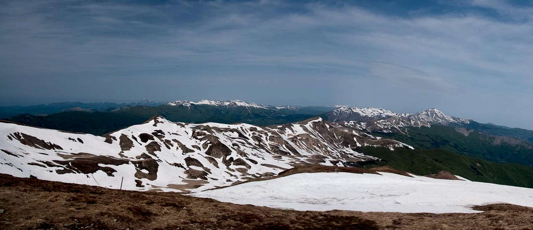
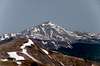
In the northern part the Appennino Tosco-Emiliano reaches elevations which hover between 1800m and 2000m. The most important, i.e. highest mountains are
- Monte Cimone (2165m)
- Monte Cusna (2121m)
- Monte Prado (2054m)
- Alpe di Succiso (2017m)
- Monte Giovo (1991m)
- Corno alle Scale (1941m)
Among these mountains there are a number of ski areas, among them the largest Italian one south of the Alps, at Abetone Pass. There also are a lot of national, natural and regional parks, all established to protect the environment of the area. See the Red Tape section for a listing.
Beyond Passo della Futa the southern Appennino Tosco-Romagnolo starts – and elevations drop. Moreover, the border between the two regions moves away from the “main ridge”, which in long stretches is not more than a series of plateau-like meadows. Only at the very end - east of Passo dei Mandroli – you can find a handful of mountains which reach across the 1500m mark with Monte Falterona and its side summit Monte Falco being the highest ones at 1655m and 1658m. Consequently this area has also been protected by a national park.
2 – Appennino Tosco Emiliano e Tosco-Romagnolo on SP
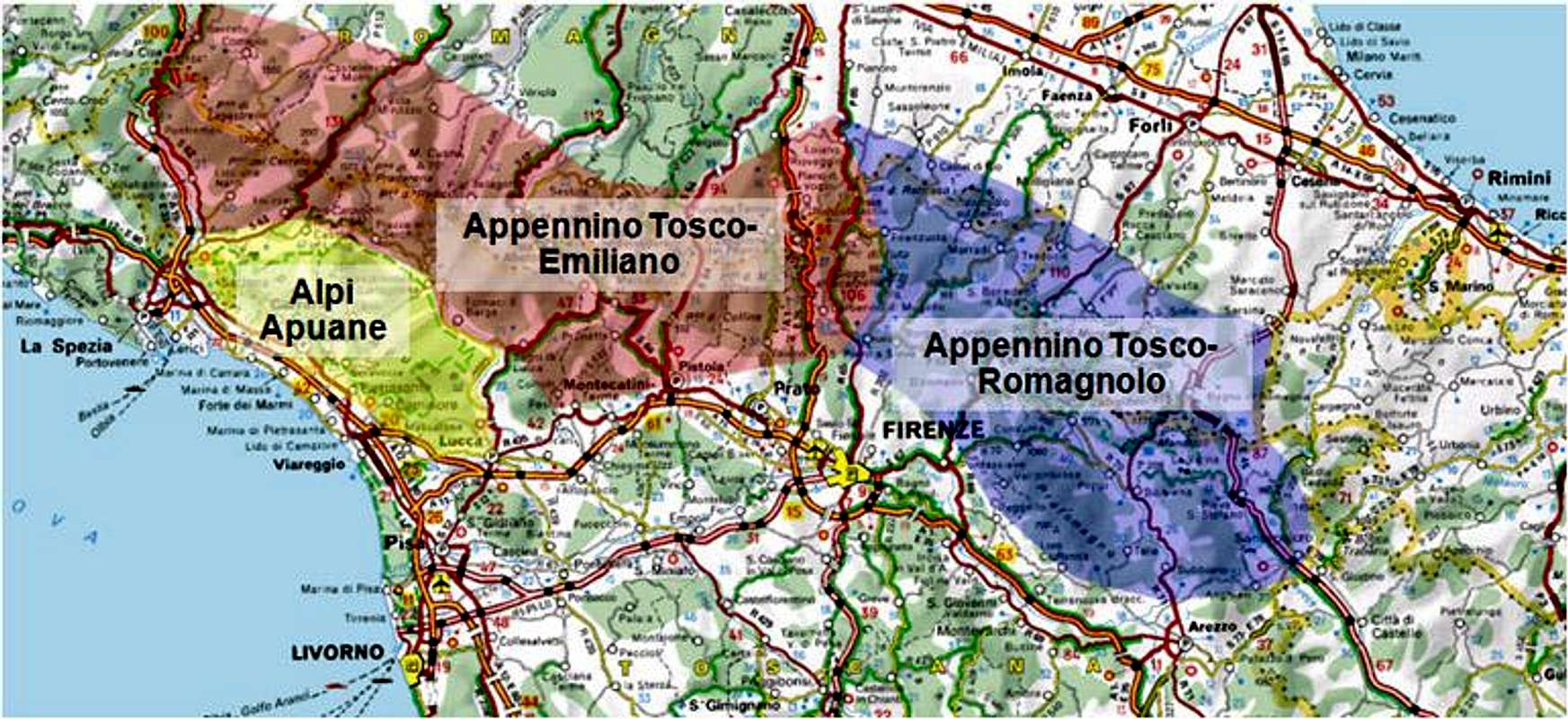 Schematic map of the greater area |
- Appennino Tosco-Emiliano
- Monte Orsaro
- Monte Scala
- Monte Marmagna
- Roccabiasca
- Monte Matto
- Monte Sillara
- Rocca Pianaccia
- Pumacioletto
- Torricella
- Alpe di Succiso
- Monte Prado
- Monte Vecchio
- Monte Cella
- Pania di Corfino
- Monte Cimone
- Monte la Piazza
- Monte Lagoni
- Libro Aperto
- Penna di Lucchio
- Monte Memoriante
- Monte Spigolino
- Il Cupolino
- Monte Cornaccio
- Corno alle Scale
- Monte Gennaio
- Appennino Tosco-Romagnolo
3 – Appennino Tosco Emiliano
3.1 – Passo Passo della Cisa – Passo di Cirone
Monte Vallora (1228m)
Monte Formigare (1212m)
Monte Conca (1183m)
Monte Tesa (1143m)
Groppo del Vescovo (1243m)
Ronconcello (1010m)
Monte Prato del Cavallo (1174m)
Monte Fontanini (1400m)
Monte Beccara (1377m)
Monte Borgognone (1401m)
3.2 - Passo di Cirone – Passo del Lagastrello (Appennino Parmese Orientale
Monte Corno (1241m)
Monte Tavola (1504m)
Monte Orsaro (1831m)
 |
Monte Braiola (1818m)
Monte Sterpara (1610m)
Monte Stellone (1221m)
Monte Casseri (1214m)
Monte Logarghena (1279m)
Monte Marmagna (1852m)
 |
Roccabiasca (1730m)
 |
Monte Brusa (1794m)
Monte Scala (1717m)
Monte Matto (1886m)
 |
Monte Naguto (1789m)
Monte Maltagliato (1510m)
Monte Cornela (1324m)
Rocca Pumaciolo (1714m)
Monte Paitino (1817m)
Monte Sillara (1861m)
 |
Rocca Pianaccia (1784)
 |
Pumacioletto (1690m)
 |
Monte Losanna (1856m)
Tecchio dei Merli (1644m)
Monte Santa Maria (1603m)
Cima la Barca (1516m)
Monte Bragalata (1784m)
Monte Torricella (1723m)
 |
Monte Bocco (1771m)
Monte Malpasso (1715m)
3.3 - Passo del Lagastrello – Passo del Cerreto
Monte Acuto (1758m)
Monte Palera (1426m)
Monte Fiascone (1162m)
Punta Buefanaro (1892m)
Monte Alto (1904m)
 |
La Rocca (1865m)
Alpe di Succiso (2016m)
 |
Il Torrione (1806m)
Monte Ramiseto (1688m)
Monte Casarola (1979m)
3.4 - Passo del Cerreto – Passo della Pradarena
Il Forame (1688m)
Monte la Nuda (1893m)
 |
Scalocchio (1726m)
La Tesa (1671m)
Cima Belfiore (1811m)
Monte Tondo (1782m)
Monte Posola (1736m)
Monte Scalocchi (1728m)
Monte Ischia (1732m)
Il Puntone (1646m)
3.5 - Passo della Pradarena – Passo delle Radici
Monte Asinara (1731m)
Monte Sillano (1876m)
Il Monte (1783m)
Monte di Soraggio (1832m)
Le Porraie (1833m)
Monte Belfiore (1760m)
Monte Ravaianda (1761m)
Monte Castellino (1949m)
Monte Brucina (1749m)
Monte Prado (2054m)
 |
Sprone di Monte Prado (1956m)
 |
Monte la Piella (2078m)
Sasso del Morto (2079m)
Monte Cusna (2121m)
 |
Monte Bagioletto (1760m)
Monte Vecchio (1982m)
 |
Monte Bocca di Scala (1846m)
 |
Pania di Corfino (1603m)
 |
Monte Cella (1942m)
 |
Le Forbici (1617m)
Monte Alto (1636m)
Monte Giovarello (1760m)
Cima la Nuda (1708m)
3.6 - Passo delle Radici – Passo dell'Abetone
 |
Monte Spicchio (1556m)
Monte Albano (1676m)
Monte Saltello (1682m)
Monte Romecchio (1688m)
Cime di Romecchio (1736m, 1764m)
Cima dell'Omo (1860m)
Monte Giovo (1994m)
 |
Grotta Rosa (1953m)
Monte Rondinaio (1829m)
 |
Cima di Salaiola (1756m)
Monte Uccelliera (1710m)
Monte Rondinaio Lombardo (1625m)
Monte Gomito (1895m)
Penna di Lucchio (1176m)
 |
Monte Memoriante (1154m)
 |
3.7 - Passo dell'Abetone – Passo della Porretta
 |
Monte Maiore (1561m)
Libro Aperto (1937m)
 |
Monte Lagoni (1962m)
 |
Monte la Piazza (1872m)
 |
Monte Cimoncino (2118m)
Monte Cimone (2165m)
 |
Monte Lancino (1702m)
Cima Tauffi (1799m)
I Balzoni (1752m)
Monte Spigolino (1827m)
 |
Il Cimonico (1671m)
 |
Il Cupolino (1853m)
Monte Cornaccio (1881m)
 |
Corno alle Scale (1941m Punta Giorgina, 1937m Punta Sofia)
 |
La Nuda (1827m)
Monte Gennaio (1814m)
 |
Poggio dei Malandrini (1662m)
Monte di Orsigna (1555m)
3.8 - Passo della Poretta – Passo della Futa
Monte la Tose (1138m)
Monte Ucellaia (1160m)
Monte Calvi (1283m)
Monte delle Seglette (1186m)
Monte della Scoperta (1278m)
Monte Casciaio (1194m)
4 – Appennino Tosco-Romagnolo
4.1 – Passo della Futa – Passo del Muraglione
Monte Gazzaro (1125m)
Sasso di Castro (1276m)
Monte Bastione (1190m)
Monte Oggioli (1290m)
Monte Beru (1263m)
Monte la Fine (993m)
Monte Faggiola (1031m)
Poggio Roncaccio (1044m)
Monte Pratone (1081m)
Poggio Cavalmagra (911m)
Monte Stelleto (1002m)
Monte Peschiena (1198m)
Monte Lavane (1241m)
Monte Pollaio (1212m)
Monte di Gamogna (1013m)
Monte Bruno (1089m)
4.2 Passo del Muraglione – Passo dei Mandrioli
Monte Campaccio (1018m)
Monte Massicaia (1365m)
Monte Falterona (1654m)
Monte Falco (1658m)
Poggio Scali (1520m)
Poggio allo Spillo (1449m)
4.3 Passo dei Mandrioli – Passo di Viamaggio
Poggio Baralla (1205m)
Monte Castelsavino (1245m)
Poggio Maggiovanna (1211m)
Monte Zuccherodante (1231m)
Punta dell'Alpuccia (1277m)
Montalto (1302m)
Poggio dei Tre Vescovi (1127m)
Monte della Zucca (1263m)
Poggio Bastione (1194m)
Monte Nero (1232m)
Poggio dell'Aquila (1037m)
Monte dei Frati (1454m)
Monte Carpegna (1415m)
 |
5 – Getting There
5.1 - Airports
The closest airport is at Firenze / Florence but there are also airports at Bologna, Pisa and Rimini, which are at a reasonable distance. For long distance travellers, obviously Rome is the best choice.
5.2 – Motorways
As can be seen from the schematic map above, the Appennino Tosco-Emiliano e Tosco-Romagnolo is surrounded by motorways.
- In the south-west: A12 (E80), the coastal motorway from Livorno to La Spezia
- In the west: A15 (E31) between La Spezia and Parma
- In the north-east: A14 (E46) between Rimini and Bologna and A1 (E35) between Bologna and Parma
- In the east: SS3bis (E45) between Perugia and Ravenna
- In the centre: A1 between Firenze and Bologna
6 – Red Tape
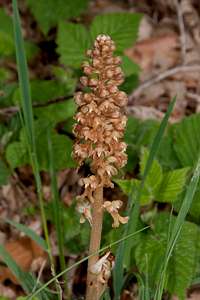 Neottia nidus-avis Neottia nidus-avis |  Orchis tridentata Orchis tridentata | 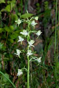 Plantanthera chlorantha Plantanthera chlorantha |
As noted in the overview section, basically the whole Appennino Tosco-Emiliano has been protected by a multitude of parks. The usual restrictions resp. flora and fauna apply. If interested, follow the links to the websites of the park. They generally contain a lot of useful information.
- Parco Regionale dell’ Alta Val Parma e Cedra (Parco dei Cento Laghi)
- Parco Nazionale dell’ Appennino Tosco-Emiliano
- Parco Regionale dell’ Appennino Modenese
- Parco Regionale di Corno alle Scale
- Parco Regionale di Laghi di Suviana e Brasimone
- Parco Nazionale delle Foreste Casentinesi Monte Falterone Campigna
7 – Accommodation
Naturally there won’t be a problem to obtain hotel rooms in any of the bigger cities or towns of the area. However, you might find yourself a bit far from your chosen destination. The ski areas also offer ample accommodation but outside the season you will be able to rent a room only in the summer month of August.Therefore, the best choice is to go for agriturismo, i.e. holiday farms which offer everything from food to lodging. Either look for signs on the roads or if you want to plan in advance have a look at the park sites, posted in the Red Tape section. Most of those sites offer accommodation lists.
- Lodging inParco Regionale dell’ Alta Val Parma e Cedra (Parco dei Cento Laghi)
- Lodging in Parco Nazionale dell’ Appennino Tosco-Emiliano
- Lodging in Parco Regionale dell’ Appennino Modenese
- Lodging in Parco Regionale di Corno alle Scale
- Lodging in Parco Regionale di Laghi di Suviana e Brasimone
- Lodging in Parco Nazionale delle Foreste Casentinesi Monte Falterone Campigna
8 – Weather Conditions
9 – Maps & Books
Let me know if you know more books or better maps. This is the set I used.Maps
I have not been able to find detailed maps of this area so the following one is a road map, scaled 1:150000
- Tuscanny - Florence
Freytag & Berndt
1:150000
ISBN: 978-3-7079-0281-5
Maps Online
Books
- Tuscany North / Toskana Nord
Wolfgang Heitzmann / Renate Gabriel (translation: Gill Round)
Rother Verlag
ISBN: 978-3-7633-4812-1 (English)
ISBN: 978-3-7633-4115-3 (German)
- Toskana Süd
Rolf Götz
Rother Verlag
ISBN: 978-3-7633-4169-6 (German)
visentin - Jan 5, 2012 6:39 am - Voted 10/10
ever thoughtof adopting the Appenino Centrale ? I'm studying the mountains in order to identify them on the pictures of my last album (Ryanair flight). Have you ever been on Vettore and Sibille ?
Gangolf Haub - Jan 5, 2012 3:27 pm - Hasn't voted
Re: ever thoughtNever been there. Just went to Tuscanny three years ago ...