
-
 5954 Hits
-
 78.27% Score
-
 9 Votes
|
|
Mountain/Rock |
|---|---|
|
|
42.84923°N / 0.20076°W |
|
|
Hiking, Mountaineering |
|
|
Summer, Fall |
|
|
9137 ft / 2785 m |
|
|
Overview
 Pic Arrouy and the ascent slope as seen from below Lay du Pourtet
Pic Arrouy is one of the many summits around Vallée de Marcadau and is - as I learned by climbing it - a marvellous viewpoint for the Pyrenée - Bigorre mountains and the adjacent ranges.
Located between the famous summits of Balaitous in the west and Vignemale in the east and standing north of the main range, Pic Arrouy offers an interesting and beautiful hike which can be combined with a round trip, the so called lakes loop (Circuit des Lacs).
Pic Arrouy is in its upper parts an off trail adventure. The lakes loop trail, a good foot trail, leads up to Lac du Pourtet, the highest point of this route. Pic Arrouy stands north of Lac du Pourtet and the last 350 meters are a very steep rock and meadow slope. There is a route marked with cairns leading smoothly through the rock parts of this slope and up the steep and exposed meadows to the summit arete.
Again: breathtaking views are waiting for you.
Getting There
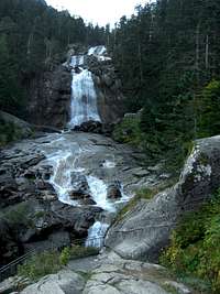 Waterfalls at Pont d´Espagne
There are three main trailheads for Pic Arrouy:
Cauterets - Pont d´Espagne
Follow D 920 from Argelès-Gazost to Cauterets and D 920 to Pont d´Espagne with the huge parking area (fee required).
This is the usual trailhead for a days hike.
Réfuge Wallon - Marcadau
French alpine club hut in the uppermost Vallée de Marcadau
From Pont d´Espagne hike up the forest road to the waterfalls (a must) and the Chalet Réfuge du Clot in the lower Vallée de Marcadau. Use the forest road on the southeast side of the valley or the trail on the northwest side up to Pont de Cayan. Ascend to the upper Vallée de Marcadau on a good foot trail until you reach the huge hut.
 Vallée de Marcadau
Réfuge d´Ilhéou
Private mountain hut at the shores of the beautiful Ilhéou lake.
Easy acces from Cauterets, parking area at the ski station du Lys and the GR 10.
Longer access from the Estaing valley, road D 103 from Arrens-Marsous via Estaing until the paring area of Lac d´Estaing. Follow GR 10 via Col d´Ilhéou.
Red Tape
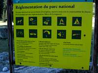 National Park regulations
Pic Arrouy and its routes are within the “Parc National des Pyrénées”. This huge national park covers about 2060 km²and has many restrictions as you can see on the picture.
Camping is generally forbidden in the national park and in a zone half an hour from outside the park borders. Near the mountain club huts special zones are reserved for overnight camping.
There are no fees to enter the park. The parking area at Pont d´Espagne requires a fee.
Main Routes Overview
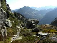
 Summit Routes Overview
All routes meet at the Lac du Pourtet. You reach this beautiful mountain lake as follows:
Pont d´Espagne
Follow the forest road through the cableway valley station up to the waterfalls of Pont d`Espagne. You can use a trail on the right hand of the road, too, it shows better the steep canyon below the waterfalls.
Pass the inn at the waterfalls at its right hand side and follow this road to the Chalet Réfuge du Clot. Now you have two possibilities: go on the forest road which leads into the Vallée de Marcadau on its left (southeastern) side or a trail which branches off the road at the Réfuge du Clot and leads into the Vallée on its right (northwestern) side. Both routes meet at the Pont de Cayan.
At Pont de Cayan follow the signposts “Circuit des Lacs”. A good foot trail ascends the south slopes of Vallée de Marcadau (Coste de Castet Abarca), zigzags up to the valley of the Lacs d´Embarrat and passes by those lakes. After another steep ascent the trail reaches Lac de Pourtet at its outlet.
 Vallée de Marcadau Vallée de Marcadau |  Lac du Pourtet Lac du Pourtet |  Aiguilles d´Arrouy and Balaitous Aiguilles d´Arrouy and Balaitous |
Réfuge Wallon
Follow the trail in the direction to Col de Cambalès and the neighbouring Réfuge Ledormeur – Balaitous. At Pé – dét – Malh, a beautiful meadow, take the right hand trail which ascends the valley between La Cardinquère in the east and Pic de Bernat-Barrau and Tuc de Bassia to the west. The trail arrives at marvellous Lac Nère and ascends to the north up to Lac du Pourtet and its outlet.
 Vignemale Vignemale |  Summit ridge Summit ridge |  Summit view with Lac du Pourtet Summit view with Lac du Pourtet |
Réfuge d´Ilhéou
Follow the trail on the east side of Ilhéou lake to the south. The trail climbs up to Col de la Haugade and traverses the east slopes of Pic de Courounalas and Aiguilles de Castet Abarca high above Vallée de Marcadau. Above the Lacs de l´Embarrat there is the trail junction with the trail from Pont du Cayan. Follow this trail up to Lac du Pourtet.
Summit route
Leave the trail at the outlet of Lac de Pourtet and follow the ridge which dams the lake in northern direction. A short meadow slope leads up to the rocks of the south ridge of Pic Arrouy. You soon will find the first cairns leading up this meadow slope and leading you through the rocks. The rocks are UIAA grade I and easier but the steep slope is quite exposed.
Above the rocks simply follow the cairn up the steep slope.
After the first half of the ascent it is easier to traverse to the ridge crest on the right hand where steep cliffs and rock faces build the limitation of the valley of the Lacs d´Embarrat. Follow the ridge crest up to the summit block, traverse then to the left ridge where the rocks of the summit block end.
 Ascent below Lac du Pourtet Ascent below Lac du Pourtet |  One of the Lacs d´Embarrat and Pic Arrouy One of the Lacs d´Embarrat and Pic Arrouy |  Summit view to the west Summit view to the west |
Follow this ridge crest over some rocks then step into the north side below the ridge and bypass on this side a more difficult part of the ridge. A short rock chute brings you back onto the ridge crest and after some more steps you arrive at the huge summit cairn.
I hope you will have this beautiful, beautiful view I had (see the panorama below).
 Summit panorama of Pic Arrouy
Accomodations
 Soaring vulture
You find all kinds of accomodations in the surrounding villages:
Nearby villages are:
The following adjacent mountain hut provide food and lodging:
Gear & Mountain Condition
 Soum de Bassia, the neighbour of Pic Arrouy and a winter ski aim
Mountain Conditions, Gear
Pic Arrouy is a late spring to mid autumn (depending on the weather and amount of snow) hike which is in its lower parts an easy hike, in its upper parts a steep and exposed off trail climb with rocks up to UIAA grade I. Nothing for wet weather because the summit has very steep meadow slopes with 350 m of altitude difference. The summit ridge, too, is quite exposed. This is what you should master.
Lac de Pourtet is a winter ski hike, too. The winter summit is not Pic Arrouy but its neighbouring summit Soum de Bassia.
Full hiking gear for a long day hike and good boots are sufficient.
Maps
The following maps can be recommended:
Carte de Randonnées, 1 : 50.000,
Pyrénées, Carte No. 3, Béarn
Institut Géographique National, Rando éditions
IGN Carte 1 : 25.000
Number 1647 OT, Vignemale, Ossau - Arrens - Cauterets
(very good topo map)